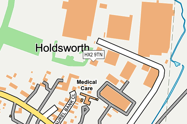
HX2 9TN lies on Holmfield Industrial Estate in Holmfield, Halifax. HX2 9TN is located in the Illingworth and Mixenden electoral ward, within the metropolitan district of Calderdale and the English Parliamentary constituency of Halifax. The Sub Integrated Care Board (ICB) Location is NHS West Yorkshire ICB - 02T and the police force is West Yorkshire. This postcode has been in use since January 1980.


GetTheData
Source: OS OpenMap – Local (Ordnance Survey)
Source: OS VectorMap District (Ordnance Survey)
Licence: Open Government Licence (requires attribution)
| Easting | 408417 |
| Northing | 429137 |
| Latitude | 53.758540 |
| Longitude | -1.873817 |
GetTheData
Source: Open Postcode Geo
Licence: Open Government Licence
| Street | Holmfield Industrial Estate |
| Locality | Holmfield |
| Town/City | Halifax |
| Country | England |
| Postcode District | HX2 |
➜ See where HX2 is on a map ➜ Where is Halifax? | |
GetTheData
Source: Land Registry Price Paid Data
Licence: Open Government Licence
Elevation or altitude of HX2 9TN as distance above sea level:
| Metres | Feet | |
|---|---|---|
| Elevation | 240m | 787ft |
Elevation is measured from the approximate centre of the postcode, to the nearest point on an OS contour line from OS Terrain 50, which has contour spacing of ten vertical metres.
➜ How high above sea level am I? Find the elevation of your current position using your device's GPS.
GetTheData
Source: Open Postcode Elevation
Licence: Open Government Licence
| Ward | Illingworth And Mixenden |
| Constituency | Halifax |
GetTheData
Source: ONS Postcode Database
Licence: Open Government Licence
UNIT 3, HOLMFIELD INDUSTRIAL ESTATE, HOLMFIELD, HALIFAX, HX2 9TN 2003 31 OCT £249,995 |
GetTheData
Source: HM Land Registry Price Paid Data
Licence: Contains HM Land Registry data © Crown copyright and database right 2025. This data is licensed under the Open Government Licence v3.0.
| Holdsworth Rd Laurel Bank Close (Holdsworth Road) | Illingworth | 240m |
| Holdsworth Rd Laurel Bank Close (Holdsworth Road) | Holmfield | 258m |
| St Catherines School (Holdworth Road) | Illingworth | 258m |
| St Catherines School (Holdsworth Road) | Illingworth | 278m |
| St Catherines School (Holdsworth Road) | Illingworth | 281m |
| Halifax Station | 4.4km |
GetTheData
Source: NaPTAN
Licence: Open Government Licence
GetTheData
Source: ONS Postcode Database
Licence: Open Government Licence


➜ Get more ratings from the Food Standards Agency
GetTheData
Source: Food Standards Agency
Licence: FSA terms & conditions
| Last Collection | |||
|---|---|---|---|
| Location | Mon-Fri | Sat | Distance |
| 2 Park Lane Queensbury | 17:45 | 12:00 | 2,840m |
| 115 Haley Hill | 17:30 | 11:45 | 3,104m |
| King Cross P.o. Box | 17:30 | 12:00 | 3,567m |
GetTheData
Source: Dracos
Licence: Creative Commons Attribution-ShareAlike
The below table lists the International Territorial Level (ITL) codes (formerly Nomenclature of Territorial Units for Statistics (NUTS) codes) and Local Administrative Units (LAU) codes for HX2 9TN:
| ITL 1 Code | Name |
|---|---|
| TLE | Yorkshire and The Humber |
| ITL 2 Code | Name |
| TLE4 | West Yorkshire |
| ITL 3 Code | Name |
| TLE44 | Calderdale and Kirklees |
| LAU 1 Code | Name |
| E08000033 | Calderdale |
GetTheData
Source: ONS Postcode Directory
Licence: Open Government Licence
The below table lists the Census Output Area (OA), Lower Layer Super Output Area (LSOA), and Middle Layer Super Output Area (MSOA) for HX2 9TN:
| Code | Name | |
|---|---|---|
| OA | E00055002 | |
| LSOA | E01010915 | Calderdale 001D |
| MSOA | E02002244 | Calderdale 001 |
GetTheData
Source: ONS Postcode Directory
Licence: Open Government Licence
| HX2 9TW | Laurel Bank Close | 144m |
| HX2 9TJ | Holdsworth Road | 168m |
| HX2 9TF | 180m | |
| HX2 9TE | 215m | |
| HX2 9TX | Holdsworth Road | 244m |
| HX2 9TH | Holdsworth Road | 281m |
| HX2 9TB | Holdsworth Road | 284m |
| HX2 9SZ | Holdsworth Road | 299m |
| HX2 9SL | Mountain View | 350m |
| HX2 9PU | Riley Lane | 367m |
GetTheData
Source: Open Postcode Geo; Land Registry Price Paid Data
Licence: Open Government Licence