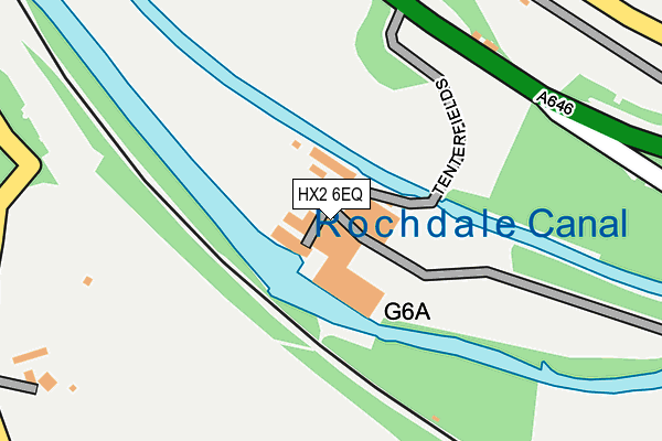
HX2 6EQ is located in the Luddendenfoot electoral ward, within the metropolitan district of Calderdale and the English Parliamentary constituency of Calder Valley. The Sub Integrated Care Board (ICB) Location is NHS West Yorkshire ICB - 02T and the police force is West Yorkshire. This postcode has been in use since April 1987.


GetTheData
Source: OS OpenMap – Local (Ordnance Survey)
Source: OS VectorMap District (Ordnance Survey)
Licence: Open Government Licence (requires attribution)
| Easting | 404179 |
| Northing | 424074 |
| Latitude | 53.713084 |
| Longitude | -1.938162 |
GetTheData
Source: Open Postcode Geo
Licence: Open Government Licence
| Country | England |
| Postcode District | HX2 |
➜ See where HX2 is on a map | |
GetTheData
Source: Land Registry Price Paid Data
Licence: Open Government Licence
Elevation or altitude of HX2 6EQ as distance above sea level:
| Metres | Feet | |
|---|---|---|
| Elevation | 80m | 262ft |
Elevation is measured from the approximate centre of the postcode, to the nearest point on an OS contour line from OS Terrain 50, which has contour spacing of ten vertical metres.
➜ How high above sea level am I? Find the elevation of your current position using your device's GPS.
GetTheData
Source: Open Postcode Elevation
Licence: Open Government Licence
| Ward | Luddendenfoot |
| Constituency | Calder Valley |
GetTheData
Source: ONS Postcode Database
Licence: Open Government Licence
| Burnley Road Rose Grove Ln (Burnley Road) | Luddenden Foot | 211m |
| Burnley Road Rose Grove Ln (Burnley Road) | Luddenden Foot | 243m |
| Burnley Road Rose Place (Burnley Road) | Luddenden Foot | 284m |
| Burnley Road Rose Place (Burnley Road) | Luddenden Foot | 289m |
| Burnley Road Cooperfields (Burnley Road) | Luddenden Foot | 411m |
| Sowerby Bridge Station | 2.1km |
| Mytholmroyd Station | 3.4km |
| Hebden Bridge Station | 5.4km |
GetTheData
Source: NaPTAN
Licence: Open Government Licence
| Median download speed | 40.0Mbps |
| Average download speed | 36.8Mbps |
| Maximum download speed | 77.72Mbps |
| Median upload speed | 7.1Mbps |
| Average upload speed | 7.7Mbps |
| Maximum upload speed | 19.31Mbps |
GetTheData
Source: Ofcom
Licence: Ofcom Terms of Use (requires attribution)
GetTheData
Source: ONS Postcode Database
Licence: Open Government Licence


➜ Get more ratings from the Food Standards Agency
GetTheData
Source: Food Standards Agency
Licence: FSA terms & conditions
| Last Collection | |||
|---|---|---|---|
| Location | Mon-Fri | Sat | Distance |
| Luddenden | 16:45 | 10:30 | 1,061m |
| Flower Bank | 17:00 | 12:00 | 1,172m |
| 31 Quarry Hill | 17:30 | 11:45 | 1,578m |
GetTheData
Source: Dracos
Licence: Creative Commons Attribution-ShareAlike
| Risk of HX2 6EQ flooding from rivers and sea | High |
| ➜ HX2 6EQ flood map | |
GetTheData
Source: Open Flood Risk by Postcode
Licence: Open Government Licence
The below table lists the International Territorial Level (ITL) codes (formerly Nomenclature of Territorial Units for Statistics (NUTS) codes) and Local Administrative Units (LAU) codes for HX2 6EQ:
| ITL 1 Code | Name |
|---|---|
| TLE | Yorkshire and The Humber |
| ITL 2 Code | Name |
| TLE4 | West Yorkshire |
| ITL 3 Code | Name |
| TLE44 | Calderdale and Kirklees |
| LAU 1 Code | Name |
| E08000033 | Calderdale |
GetTheData
Source: ONS Postcode Directory
Licence: Open Government Licence
The below table lists the Census Output Area (OA), Lower Layer Super Output Area (LSOA), and Middle Layer Super Output Area (MSOA) for HX2 6EQ:
| Code | Name | |
|---|---|---|
| OA | E00055040 | |
| LSOA | E01010922 | Calderdale 020A |
| MSOA | E02002263 | Calderdale 020 |
GetTheData
Source: ONS Postcode Directory
Licence: Open Government Licence
| HX2 6BB | Belmont Terrace | 261m |
| HX2 6DG | Stonecroft Fold | 266m |
| HX2 6BA | Beulah Place | 273m |
| HX2 6AZ | Rose Place | 319m |
| HX2 6BU | John Naylor Lane | 346m |
| HX2 6BT | Victoria Place | 348m |
| HX2 6AY | Victoria Terrace | 360m |
| HX2 6BP | Winter Neb | 363m |
| HX2 6AU | Burnley Road | 372m |
| HX6 1NG | Finkle Street | 385m |
GetTheData
Source: Open Postcode Geo; Land Registry Price Paid Data
Licence: Open Government Licence