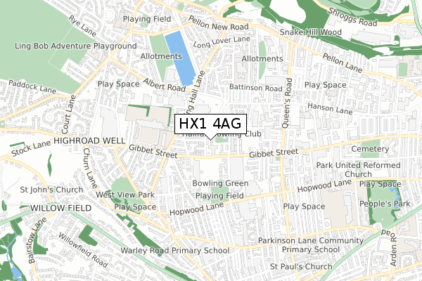
HX1 4AG is located in the Warley electoral ward, within the metropolitan district of Calderdale and the English Parliamentary constituency of Halifax. The Sub Integrated Care Board (ICB) Location is NHS West Yorkshire ICB - 02T and the police force is West Yorkshire. This postcode has been in use since October 2019.


GetTheData
Source: OS Open Zoomstack (Ordnance Survey)
Licence: Open Government Licence (requires attribution)
Attribution: Contains OS data © Crown copyright and database right 2025
Source: Open Postcode Geo
Licence: Open Government Licence (requires attribution)
Attribution: Contains OS data © Crown copyright and database right 2025; Contains Royal Mail data © Royal Mail copyright and database right 2025; Source: Office for National Statistics licensed under the Open Government Licence v.3.0
| Easting | 407482 |
| Northing | 425216 |
| Latitude | 53.723312 |
| Longitude | -1.888091 |
GetTheData
Source: Open Postcode Geo
Licence: Open Government Licence
| Country | England |
| Postcode District | HX1 |
➜ See where HX1 is on a map ➜ Where is Halifax? | |
GetTheData
Source: Land Registry Price Paid Data
Licence: Open Government Licence
| Ward | Warley |
| Constituency | Halifax |
GetTheData
Source: ONS Postcode Database
Licence: Open Government Licence
2024 11 MAR £425,000 |
2020 25 MAR £307,000 |
3, BOWLING GREEN PLACE, HALIFAX, HX1 4AG 2020 31 JAN £328,000 |
1 BOWLING GREEN PLACE, THRUM HALL LANE, HALIFAX, HX1 4AG 2019 18 DEC £295,000 |
GetTheData
Source: HM Land Registry Price Paid Data
Licence: Contains HM Land Registry data © Crown copyright and database right 2025. This data is licensed under the Open Government Licence v3.0.
| Gibbet St Newstead Terrace (Gibbet Street) | King Cross | 94m |
| Gibbet Street Westholme Rd (Gibbet Street) | King Cross | 126m |
| Gibbet Street | King Cross | 135m |
| Gibbet Street Thrum Hall Ln (Gibbet Street) | King Cross | 154m |
| Spring Hall Lane Spring Grove (Spring Hall Lane) | Pellon | 199m |
| Sowerby Bridge Station | 2.1km |
| Halifax Station | 2.3km |
GetTheData
Source: NaPTAN
Licence: Open Government Licence
GetTheData
Source: ONS Postcode Database
Licence: Open Government Licence


➜ Get more ratings from the Food Standards Agency
GetTheData
Source: Food Standards Agency
Licence: FSA terms & conditions
| Last Collection | |||
|---|---|---|---|
| Location | Mon-Fri | Sat | Distance |
| Scar Bottom P.o. Box | 17:30 | 11:45 | 1,120m |
| Scarr Bottom Road | 17:15 | 11:45 | 1,279m |
| King Cross P.o. Box | 17:30 | 12:00 | 1,308m |
GetTheData
Source: Dracos
Licence: Creative Commons Attribution-ShareAlike
The below table lists the International Territorial Level (ITL) codes (formerly Nomenclature of Territorial Units for Statistics (NUTS) codes) and Local Administrative Units (LAU) codes for HX1 4AG:
| ITL 1 Code | Name |
|---|---|
| TLE | Yorkshire and The Humber |
| ITL 2 Code | Name |
| TLE4 | West Yorkshire |
| ITL 3 Code | Name |
| TLE44 | Calderdale and Kirklees |
| LAU 1 Code | Name |
| E08000033 | Calderdale |
GetTheData
Source: ONS Postcode Directory
Licence: Open Government Licence
The below table lists the Census Output Area (OA), Lower Layer Super Output Area (LSOA), and Middle Layer Super Output Area (MSOA) for HX1 4AG:
| Code | Name | |
|---|---|---|
| OA | E00055430 | |
| LSOA | E01011000 | Calderdale 010D |
| MSOA | E02002253 | Calderdale 010 |
GetTheData
Source: ONS Postcode Directory
Licence: Open Government Licence
| HX1 4TA | Newstead Terrace | 29m |
| HX1 4TB | Newstead Gardens | 83m |
| HX1 4TD | Newstead Grove | 101m |
| HX1 4TQ | Newstead Place | 112m |
| HX1 4TH | Glenholme Heath | 125m |
| HX1 4JT | Thrum Hall Lane | 126m |
| HX1 4TE | Newstead Avenue | 138m |
| HX1 4TJ | Newstead Heath | 140m |
| HX1 4JW | Gibbet Street | 142m |
| HX1 4JU | Ashbourne Grove | 147m |
GetTheData
Source: Open Postcode Geo; Land Registry Price Paid Data
Licence: Open Government Licence