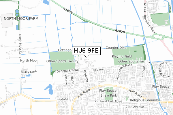
HU6 9FE is located in the Cottingham North electoral ward, within the unitary authority of East Riding of Yorkshire and the English Parliamentary constituency of Haltemprice and Howden. The Sub Integrated Care Board (ICB) Location is NHS Humber and North Yorkshire ICB - 02Y and the police force is Humberside. This postcode has been in use since April 2019.


GetTheData
Source: OS Open Zoomstack (Ordnance Survey)
Licence: Open Government Licence (requires attribution)
Attribution: Contains OS data © Crown copyright and database right 2024
Source: Open Postcode Geo
Licence: Open Government Licence (requires attribution)
Attribution: Contains OS data © Crown copyright and database right 2024; Contains Royal Mail data © Royal Mail copyright and database right 2024; Source: Office for National Statistics licensed under the Open Government Licence v.3.0
| Easting | 506697 |
| Northing | 434175 |
| Latitude | 53.792978 |
| Longitude | -0.381766 |
GetTheData
Source: Open Postcode Geo
Licence: Open Government Licence
| Country | England |
| Postcode District | HU6 |
➜ See where HU6 is on a map ➜ Where is Kingston upon Hull? | |
GetTheData
Source: Land Registry Price Paid Data
Licence: Open Government Licence
| Ward | Cottingham North |
| Constituency | Haltemprice And Howden |
GetTheData
Source: ONS Postcode Database
Licence: Open Government Licence
4, HARDY CROFT, HULL, HU6 9FE 2023 31 AUG £189,995 |
➜ Kingston upon Hull house prices
GetTheData
Source: HM Land Registry Price Paid Data
Licence: Contains HM Land Registry data © Crown copyright and database right 2024. This data is licensed under the Open Government Licence v3.0.
| Hall Road | North Hull Estate | 425m |
| Hall Road | North Hull Estate | 460m |
| The Rampant Horse Ph (Hall Road) | North Hull Estate | 641m |
| The Pint And Pot Ph (Hall Road) | North Hull Estate | 647m |
| Cladshaw (Orchard Park Road) | North Hull Estate | 650m |
| Cottingham Station | 2.1km |
GetTheData
Source: NaPTAN
Licence: Open Government Licence
GetTheData
Source: ONS Postcode Database
Licence: Open Government Licence


➜ Get more ratings from the Food Standards Agency
GetTheData
Source: Food Standards Agency
Licence: FSA terms & conditions
| Last Collection | |||
|---|---|---|---|
| Location | Mon-Fri | Sat | Distance |
| Orchard Park Post Office | 17:00 | 11:30 | 654m |
| Downfield Avenue Hull | 17:15 | 10:30 | 1,056m |
| Tudor Drive Hull | 17:00 | 10:30 | 1,119m |
GetTheData
Source: Dracos
Licence: Creative Commons Attribution-ShareAlike
| Risk of HU6 9FE flooding from rivers and sea | Medium |
| ➜ HU6 9FE flood map | |
GetTheData
Source: Open Flood Risk by Postcode
Licence: Open Government Licence
The below table lists the International Territorial Level (ITL) codes (formerly Nomenclature of Territorial Units for Statistics (NUTS) codes) and Local Administrative Units (LAU) codes for HU6 9FE:
| ITL 1 Code | Name |
|---|---|
| TLE | Yorkshire and The Humber |
| ITL 2 Code | Name |
| TLE1 | East Yorkshire and Northern Lincolnshire |
| ITL 3 Code | Name |
| TLE12 | East Riding of Yorkshire |
| LAU 1 Code | Name |
| E06000011 | East Riding of Yorkshire |
GetTheData
Source: ONS Postcode Directory
Licence: Open Government Licence
The below table lists the Census Output Area (OA), Lower Layer Super Output Area (LSOA), and Middle Layer Super Output Area (MSOA) for HU6 9FE:
| Code | Name | |
|---|---|---|
| OA | E00065346 | |
| LSOA | E01012953 | East Riding of Yorkshire 023A |
| MSOA | E02002706 | East Riding of Yorkshire 023 |
GetTheData
Source: ONS Postcode Directory
Licence: Open Government Licence
| HU6 9EE | Jipdane | 174m |
| HU6 9ED | Jipdane | 222m |
| HU6 9EB | Kerdane | 291m |
| HU6 9HE | Clanthorpe | 295m |
| HU6 9AF | Dane Park Road | 326m |
| HU6 9HG | Blythorpe | 350m |
| HU6 9DZ | Isledane | 353m |
| HU6 9EA | Limedane | 379m |
| HU6 9BD | 400m | |
| HU6 9BG | Hardane | 408m |
GetTheData
Source: Open Postcode Geo; Land Registry Price Paid Data
Licence: Open Government Licence