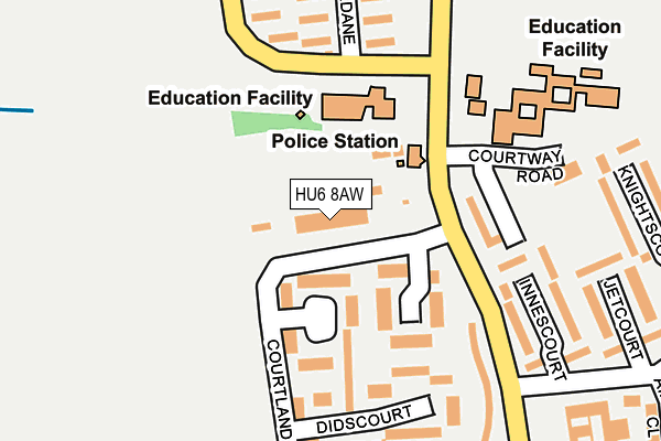
HU6 8AW is located in the Orchard Park electoral ward, within the unitary authority of Kingston upon Hull, City of and the English Parliamentary constituency of Kingston upon Hull North. The Sub Integrated Care Board (ICB) Location is NHS Humber and North Yorkshire ICB - 03F and the police force is Humberside. This postcode has been in use since April 2017.


GetTheData
Source: OS OpenMap – Local (Ordnance Survey)
Source: OS VectorMap District (Ordnance Survey)
Licence: Open Government Licence (requires attribution)
| Easting | 506207 |
| Northing | 433112 |
| Latitude | 53.783528 |
| Longitude | -0.389567 |
GetTheData
Source: Open Postcode Geo
Licence: Open Government Licence
| Country | England |
| Postcode District | HU6 |
➜ See where HU6 is on a map ➜ Where is Kingston upon Hull? | |
GetTheData
Source: Land Registry Price Paid Data
Licence: Open Government Licence
| Ward | Orchard Park |
| Constituency | Kingston Upon Hull North |
GetTheData
Source: ONS Postcode Database
Licence: Open Government Licence
| Highcourt (Hall Road) | Orchard Park | 126m |
| Courtland Road (Hall Road) | Orchard Park | 129m |
| Danepark Road (Hall Road) | Orchard Park | 199m |
| Glencourt (Hall Road) | Orchard Park | 264m |
| Saxcourt (Hall Road) | Orchard Park | 267m |
| Cottingham Station | 1.1km |
| Hull Station | 5.2km |
GetTheData
Source: NaPTAN
Licence: Open Government Licence
GetTheData
Source: ONS Postcode Database
Licence: Open Government Licence


➜ Get more ratings from the Food Standards Agency
GetTheData
Source: Food Standards Agency
Licence: FSA terms & conditions
| Last Collection | |||
|---|---|---|---|
| Location | Mon-Fri | Sat | Distance |
| Courtland Road Hull | 16:45 | 11:30 | 121m |
| Greenwood Avenue Hull | 16:45 | 11:45 | 496m |
| Lytham Drive | 17:30 | 10:45 | 834m |
GetTheData
Source: Dracos
Licence: Creative Commons Attribution-ShareAlike
| Risk of HU6 8AW flooding from rivers and sea | Low |
| ➜ HU6 8AW flood map | |
GetTheData
Source: Open Flood Risk by Postcode
Licence: Open Government Licence
The below table lists the International Territorial Level (ITL) codes (formerly Nomenclature of Territorial Units for Statistics (NUTS) codes) and Local Administrative Units (LAU) codes for HU6 8AW:
| ITL 1 Code | Name |
|---|---|
| TLE | Yorkshire and The Humber |
| ITL 2 Code | Name |
| TLE1 | East Yorkshire and Northern Lincolnshire |
| ITL 3 Code | Name |
| TLE11 | Kingston upon Hull, City of |
| LAU 1 Code | Name |
| E06000010 | Kingston upon Hull, City of |
GetTheData
Source: ONS Postcode Directory
Licence: Open Government Licence
The below table lists the Census Output Area (OA), Lower Layer Super Output Area (LSOA), and Middle Layer Super Output Area (MSOA) for HU6 8AW:
| Code | Name | |
|---|---|---|
| OA | E00064950 | |
| LSOA | E01012874 | Kingston upon Hull 008B |
| MSOA | E02002659 | Kingston upon Hull 008 |
GetTheData
Source: ONS Postcode Directory
Licence: Open Government Licence
| HU6 8BG | Faircourt | 89m |
| HU6 8BD | Earlescourt | 102m |
| HU6 8BB | Didscourt | 198m |
| HU6 9AE | Axdane | 205m |
| HU6 9SS | Innescourt | 225m |
| HU6 8BA | Chadcourt | 243m |
| HU6 9AB | Axdane | 247m |
| HU6 9AD | Axdane | 277m |
| HU6 9SR | Jetcourt | 291m |
| HU6 9TP | Saxcourt | 298m |
GetTheData
Source: Open Postcode Geo; Land Registry Price Paid Data
Licence: Open Government Licence