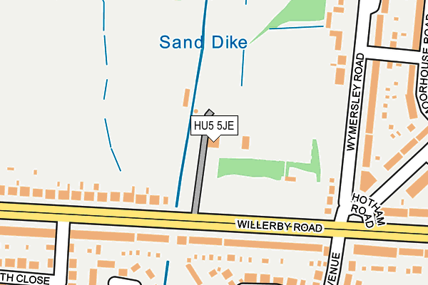
HU5 5JE is located in the Derringham electoral ward, within the unitary authority of Kingston upon Hull, City of and the English Parliamentary constituency of Kingston upon Hull West and Hessle. The Sub Integrated Care Board (ICB) Location is NHS Humber and North Yorkshire ICB - 03F and the police force is Humberside. This postcode has been in use since January 1980.


GetTheData
Source: OS OpenMap – Local (Ordnance Survey)
Source: OS VectorMap District (Ordnance Survey)
Licence: Open Government Licence (requires attribution)
| Easting | 504276 |
| Northing | 429800 |
| Latitude | 53.754140 |
| Longitude | -0.419973 |
GetTheData
Source: Open Postcode Geo
Licence: Open Government Licence
| Country | England |
| Postcode District | HU5 |
➜ See where HU5 is on a map ➜ Where is Kingston upon Hull? | |
GetTheData
Source: Land Registry Price Paid Data
Licence: Open Government Licence
Elevation or altitude of HU5 5JE as distance above sea level:
| Metres | Feet | |
|---|---|---|
| Elevation | 10m | 33ft |
Elevation is measured from the approximate centre of the postcode, to the nearest point on an OS contour line from OS Terrain 50, which has contour spacing of ten vertical metres.
➜ How high above sea level am I? Find the elevation of your current position using your device's GPS.
GetTheData
Source: Open Postcode Elevation
Licence: Open Government Licence
| Ward | Derringham |
| Constituency | Kingston Upon Hull West And Hessle |
GetTheData
Source: ONS Postcode Database
Licence: Open Government Licence
| Willerby Kingston Road (Kingston Road) | Willerby | 128m |
| Willerby Kingston Road (Kingston Road) | Willerby | 158m |
| Wymersley Road (The Highway Ph ) (Wymersley Road) | Derringham | 180m |
| The Highway Ph (Wymersley Road) | Derringham | 201m |
| Hotham Road South (Willerby Road) | Derringham | 273m |
| Cottingham Station | 3.2km |
| Hessle Station | 4.3km |
| Hull Station | 5km |
GetTheData
Source: NaPTAN
Licence: Open Government Licence
GetTheData
Source: ONS Postcode Database
Licence: Open Government Licence


➜ Get more ratings from the Food Standards Agency
GetTheData
Source: Food Standards Agency
Licence: FSA terms & conditions
| Last Collection | |||
|---|---|---|---|
| Location | Mon-Fri | Sat | Distance |
| Wymersley Road Hull | 17:00 | 11:00 | 256m |
| Wolfreton Lane Willerby | 17:00 | 12:30 | 486m |
| Sandicroft Close Hull | 17:15 | 11:00 | 630m |
GetTheData
Source: Dracos
Licence: Creative Commons Attribution-ShareAlike
The below table lists the International Territorial Level (ITL) codes (formerly Nomenclature of Territorial Units for Statistics (NUTS) codes) and Local Administrative Units (LAU) codes for HU5 5JE:
| ITL 1 Code | Name |
|---|---|
| TLE | Yorkshire and The Humber |
| ITL 2 Code | Name |
| TLE1 | East Yorkshire and Northern Lincolnshire |
| ITL 3 Code | Name |
| TLE11 | Kingston upon Hull, City of |
| LAU 1 Code | Name |
| E06000010 | Kingston upon Hull, City of |
GetTheData
Source: ONS Postcode Directory
Licence: Open Government Licence
The below table lists the Census Output Area (OA), Lower Layer Super Output Area (LSOA), and Middle Layer Super Output Area (MSOA) for HU5 5JE:
| Code | Name | |
|---|---|---|
| OA | E00064554 | |
| LSOA | E01012800 | Kingston upon Hull 023C |
| MSOA | E02002674 | Kingston upon Hull 023 |
GetTheData
Source: ONS Postcode Directory
Licence: Open Government Licence
| HU5 5JD | Willerby Road | 152m |
| HU5 5LQ | Wymersley Road | 179m |
| HU10 6NG | Kingston Road | 186m |
| HU10 6PY | Kingston Road | 189m |
| HU5 5LJ | Wymersley Road | 225m |
| HU5 5HW | The Ridings | 230m |
| HU10 6NP | Fulford Crescent | 264m |
| HU5 5LG | Hotham Road South | 268m |
| HU5 5LP | Wymersley Road | 270m |
| HU5 5PW | Moorhouse Road | 285m |
GetTheData
Source: Open Postcode Geo; Land Registry Price Paid Data
Licence: Open Government Licence