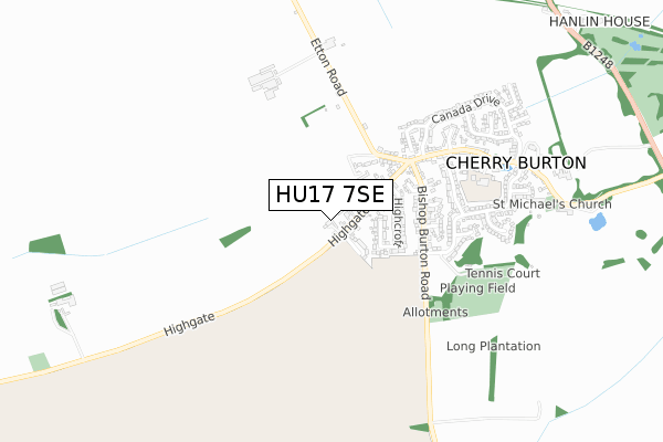
HU17 7SE is located in the Beverley Rural electoral ward, within the unitary authority of East Riding of Yorkshire and the English Parliamentary constituency of Beverley and Holderness. The Sub Integrated Care Board (ICB) Location is NHS Humber and North Yorkshire ICB - 02Y and the police force is Humberside. This postcode has been in use since February 2018.


GetTheData
Source: OS Open Zoomstack (Ordnance Survey)
Licence: Open Government Licence (requires attribution)
Attribution: Contains OS data © Crown copyright and database right 2025
Source: Open Postcode Geo
Licence: Open Government Licence (requires attribution)
Attribution: Contains OS data © Crown copyright and database right 2025; Contains Royal Mail data © Royal Mail copyright and database right 2025; Source: Office for National Statistics licensed under the Open Government Licence v.3.0
| Easting | 498466 |
| Northing | 441894 |
| Latitude | 53.863951 |
| Longitude | -0.504202 |
GetTheData
Source: Open Postcode Geo
Licence: Open Government Licence
| Country | England |
| Postcode District | HU17 |
➜ See where HU17 is on a map ➜ Where is Cherry Burton? | |
GetTheData
Source: Land Registry Price Paid Data
Licence: Open Government Licence
| Ward | Beverley Rural |
| Constituency | Beverley And Holderness |
GetTheData
Source: ONS Postcode Database
Licence: Open Government Licence
4, BURTON RISE, CHERRY BURTON, BEVERLEY, HU17 7SE 2019 15 OCT £125,000 |
3, BURTON RISE, CHERRY BURTON, BEVERLEY, HU17 7SE 2018 15 MAR £525,000 |
GetTheData
Source: HM Land Registry Price Paid Data
Licence: Contains HM Land Registry data © Crown copyright and database right 2025. This data is licensed under the Open Government Licence v3.0.
| Cherry Burton Main Street (Main Street) | Cherry Burton | 393m |
| Cherry Burton Etton Road (Etton Road) | Cherry Burton | 485m |
| Cherry Burton Etton Road (Etton Road) | Cherry Burton | 502m |
| Cherry Burton Main Street (Canada Drive) | Cherry Burton | 704m |
| Cherry Burton Main Street (Main Street) | Cherry Burton | 742m |
GetTheData
Source: NaPTAN
Licence: Open Government Licence
| Percentage of properties with Next Generation Access | 100.0% |
| Percentage of properties with Superfast Broadband | 100.0% |
| Percentage of properties with Ultrafast Broadband | 100.0% |
| Percentage of properties with Full Fibre Broadband | 100.0% |
Superfast Broadband is between 30Mbps and 300Mbps
Ultrafast Broadband is > 300Mbps
| Percentage of properties unable to receive 2Mbps | 0.0% |
| Percentage of properties unable to receive 5Mbps | 0.0% |
| Percentage of properties unable to receive 10Mbps | 0.0% |
| Percentage of properties unable to receive 30Mbps | 0.0% |
GetTheData
Source: Ofcom
Licence: Ofcom Terms of Use (requires attribution)
GetTheData
Source: ONS Postcode Database
Licence: Open Government Licence


➜ Get more ratings from the Food Standards Agency
GetTheData
Source: Food Standards Agency
Licence: FSA terms & conditions
| Last Collection | |||
|---|---|---|---|
| Location | Mon-Fri | Sat | Distance |
| Old Road | 16:30 | 11:00 | 3,236m |
| Leconfield Post Office | 16:30 | 11:00 | 3,417m |
| Woodhall Way Post Office | 17:15 | 11:15 | 4,532m |
GetTheData
Source: Dracos
Licence: Creative Commons Attribution-ShareAlike
The below table lists the International Territorial Level (ITL) codes (formerly Nomenclature of Territorial Units for Statistics (NUTS) codes) and Local Administrative Units (LAU) codes for HU17 7SE:
| ITL 1 Code | Name |
|---|---|
| TLE | Yorkshire and The Humber |
| ITL 2 Code | Name |
| TLE1 | East Yorkshire and Northern Lincolnshire |
| ITL 3 Code | Name |
| TLE12 | East Riding of Yorkshire |
| LAU 1 Code | Name |
| E06000011 | East Riding of Yorkshire |
GetTheData
Source: ONS Postcode Directory
Licence: Open Government Licence
The below table lists the Census Output Area (OA), Lower Layer Super Output Area (LSOA), and Middle Layer Super Output Area (MSOA) for HU17 7SE:
| Code | Name | |
|---|---|---|
| OA | E00065172 | |
| LSOA | E01012925 | East Riding of Yorkshire 013C |
| MSOA | E02002696 | East Riding of Yorkshire 013 |
GetTheData
Source: ONS Postcode Directory
Licence: Open Government Licence
| HU17 7RS | The Drive | 135m |
| HU17 7RR | Highgate | 162m |
| HU17 7QU | Etton Road | 196m |
| HU17 7SG | Highcroft | 227m |
| HU17 7RW | Bishop Burton Road | 317m |
| HU17 7RP | Etton Road | 327m |
| HU17 7SH | Two Riggs | 404m |
| HU17 7SJ | Thornleys | 406m |
| HU17 7SD | The Meadows | 452m |
| HU17 7SB | Canada Drive | 483m |
GetTheData
Source: Open Postcode Geo; Land Registry Price Paid Data
Licence: Open Government Licence