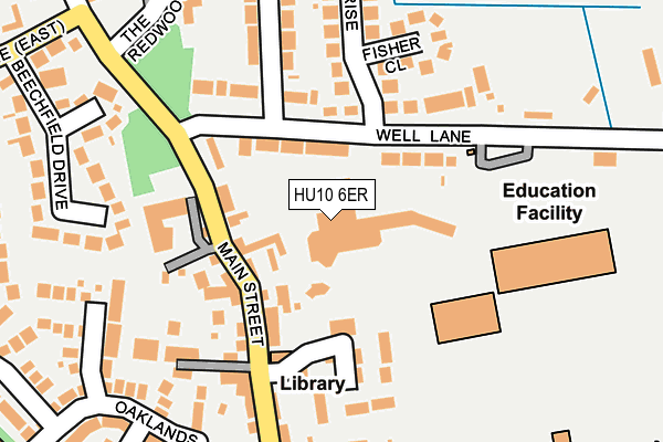
HU10 6ER is located in the Willerby and Kirk Ella electoral ward, within the unitary authority of East Riding of Yorkshire and the English Parliamentary constituency of Haltemprice and Howden. The Sub Integrated Care Board (ICB) Location is NHS Humber and North Yorkshire ICB - 02Y and the police force is Humberside. This postcode has been in use since January 1980.


GetTheData
Source: OS OpenMap – Local (Ordnance Survey)
Source: OS VectorMap District (Ordnance Survey)
Licence: Open Government Licence (requires attribution)
| Easting | 502539 |
| Northing | 430489 |
| Latitude | 53.760675 |
| Longitude | -0.446079 |
GetTheData
Source: Open Postcode Geo
Licence: Open Government Licence
| Country | England |
| Postcode District | HU10 |
➜ See where HU10 is on a map ➜ Where is Willerby? | |
GetTheData
Source: Land Registry Price Paid Data
Licence: Open Government Licence
Elevation or altitude of HU10 6ER as distance above sea level:
| Metres | Feet | |
|---|---|---|
| Elevation | 20m | 66ft |
Elevation is measured from the approximate centre of the postcode, to the nearest point on an OS contour line from OS Terrain 50, which has contour spacing of ten vertical metres.
➜ How high above sea level am I? Find the elevation of your current position using your device's GPS.
GetTheData
Source: Open Postcode Elevation
Licence: Open Government Licence
| Ward | Willerby And Kirk Ella |
| Constituency | Haltemprice And Howden |
GetTheData
Source: ONS Postcode Database
Licence: Open Government Licence
| Willerby Well Lane (Well Lane) | Willerby | 107m |
| Willerby Well Lane (Well Lane) | Willerby | 115m |
| Willerby Well Lane (Well Lane) | Willerby | 141m |
| Willerby Well Lane (Well Lane) | Willerby | 146m |
| Willerby Main Street (Main Street) | Willerby | 159m |
| Cottingham Station | 3.5km |
| Hessle Station | 4.8km |
| Ferriby Station | 6.3km |
GetTheData
Source: NaPTAN
Licence: Open Government Licence
GetTheData
Source: ONS Postcode Database
Licence: Open Government Licence


➜ Get more ratings from the Food Standards Agency
GetTheData
Source: Food Standards Agency
Licence: FSA terms & conditions
| Last Collection | |||
|---|---|---|---|
| Location | Mon-Fri | Sat | Distance |
| Well Lane Willerby | 17:30 | 12:00 | 186m |
| Willerby Square Post Office | 17:00 | 12:15 | 369m |
| Southella | 17:15 | 11:00 | 377m |
GetTheData
Source: Dracos
Licence: Creative Commons Attribution-ShareAlike
The below table lists the International Territorial Level (ITL) codes (formerly Nomenclature of Territorial Units for Statistics (NUTS) codes) and Local Administrative Units (LAU) codes for HU10 6ER:
| ITL 1 Code | Name |
|---|---|
| TLE | Yorkshire and The Humber |
| ITL 2 Code | Name |
| TLE1 | East Yorkshire and Northern Lincolnshire |
| ITL 3 Code | Name |
| TLE12 | East Riding of Yorkshire |
| LAU 1 Code | Name |
| E06000011 | East Riding of Yorkshire |
GetTheData
Source: ONS Postcode Directory
Licence: Open Government Licence
The below table lists the Census Output Area (OA), Lower Layer Super Output Area (LSOA), and Middle Layer Super Output Area (MSOA) for HU10 6ER:
| Code | Name | |
|---|---|---|
| OA | E00066169 | |
| LSOA | E01013113 | East Riding of Yorkshire 028B |
| MSOA | E02002711 | East Riding of Yorkshire 028 |
GetTheData
Source: ONS Postcode Directory
Licence: Open Government Licence
| HU10 6EP | Well Lane | 83m |
| HU10 6BZ | Main Street | 86m |
| HU10 6BY | Main Street | 117m |
| HU10 6XZ | John Gray Court | 145m |
| HU10 6HB | Well Lane | 169m |
| HU10 6HA | Fisher Close | 193m |
| HU10 6BU | Main Street | 223m |
| HU10 6EX | Ellerker Rise | 227m |
| HU10 6DF | Beechfield Drive | 234m |
| HU10 6ES | Derrymore Road | 235m |
GetTheData
Source: Open Postcode Geo; Land Registry Price Paid Data
Licence: Open Government Licence