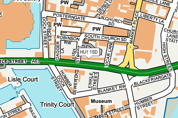
HU1 1SD is located in the St Andrew's & Docklands electoral ward, within the unitary authority of Kingston upon Hull, City of and the English Parliamentary constituency of Kingston upon Hull West and Hessle. The Sub Integrated Care Board (ICB) Location is NHS Humber and North Yorkshire ICB - 03F and the police force is Humberside. This postcode has been in use since September 1991.


GetTheData
Source: OS OpenMap – Local (Ordnance Survey)
Source: OS VectorMap District (Ordnance Survey)
Licence: Open Government Licence (requires attribution)
| Easting | 509869 |
| Northing | 428459 |
| Latitude | 53.740945 |
| Longitude | -0.335662 |
GetTheData
Source: Open Postcode Geo
Licence: Open Government Licence
| Country | England |
| Postcode District | HU1 |
➜ See where HU1 is on a map ➜ Where is Kingston upon Hull? | |
GetTheData
Source: Land Registry Price Paid Data
Licence: Open Government Licence
Elevation or altitude of HU1 1SD as distance above sea level:
| Metres | Feet | |
|---|---|---|
| Elevation | 0m | 0ft |
Elevation is measured from the approximate centre of the postcode, to the nearest point on an OS contour line from OS Terrain 50, which has contour spacing of ten vertical metres.
➜ How high above sea level am I? Find the elevation of your current position using your device's GPS.
GetTheData
Source: Open Postcode Elevation
Licence: Open Government Licence
| Ward | St Andrew's & Docklands |
| Constituency | Kingston Upon Hull West And Hessle |
GetTheData
Source: ONS Postcode Database
Licence: Open Government Licence
| Holy Trinity Church (Market Place) | Hull | 139m |
| King William House (Market Place) | Hull | 168m |
| Humber Street (High Street) | Hull | 255m |
| Wellington Street (Humber Dock Street) | Hull | 269m |
| Liberty Lane (High Street) | Hull | 270m |
| Hull Station | 0.8km |
| New Holland Station | 4.6km |
| Barrow Haven Station | 6.1km |
GetTheData
Source: NaPTAN
Licence: Open Government Licence
GetTheData
Source: ONS Postcode Database
Licence: Open Government Licence

➜ Get more ratings from the Food Standards Agency
GetTheData
Source: Food Standards Agency
Licence: FSA terms & conditions
| Last Collection | |||
|---|---|---|---|
| Location | Mon-Fri | Sat | Distance |
| Queen Street Hull | 18:30 | 12:00 | 158m |
| Whitefriargate | 18:30 | 11:45 | 249m |
| Lowgate Post Office | 18:30 | 11:30 | 382m |
GetTheData
Source: Dracos
Licence: Creative Commons Attribution-ShareAlike
| Risk of HU1 1SD flooding from rivers and sea | Medium |
| ➜ HU1 1SD flood map | |
GetTheData
Source: Open Flood Risk by Postcode
Licence: Open Government Licence
The below table lists the International Territorial Level (ITL) codes (formerly Nomenclature of Territorial Units for Statistics (NUTS) codes) and Local Administrative Units (LAU) codes for HU1 1SD:
| ITL 1 Code | Name |
|---|---|
| TLE | Yorkshire and The Humber |
| ITL 2 Code | Name |
| TLE1 | East Yorkshire and Northern Lincolnshire |
| ITL 3 Code | Name |
| TLE11 | Kingston upon Hull, City of |
| LAU 1 Code | Name |
| E06000010 | Kingston upon Hull, City of |
GetTheData
Source: ONS Postcode Directory
Licence: Open Government Licence
The below table lists the Census Output Area (OA), Lower Layer Super Output Area (LSOA), and Middle Layer Super Output Area (MSOA) for HU1 1SD:
| Code | Name | |
|---|---|---|
| OA | E00064824 | |
| LSOA | E01033104 | Kingston upon Hull 029E |
| MSOA | E02002680 | Kingston upon Hull 029 |
GetTheData
Source: ONS Postcode Directory
Licence: Open Government Licence
| HU1 1SE | Grammar School Yard | 28m |
| HU1 2NB | Fish Street | 58m |
| HU1 2LY | Castle Street | 74m |
| HU1 2NA | Robinson Row | 91m |
| HU1 2QX | Robinson Row | 98m |
| HU1 2JJ | King Street | 102m |
| HU1 2LZ | Dagger Lane | 104m |
| HU1 2JP | Posterngate | 123m |
| HU1 2LU | Dagger Lane | 127m |
| HU1 2LJ | Prince Street | 129m |
GetTheData
Source: Open Postcode Geo; Land Registry Price Paid Data
Licence: Open Government Licence