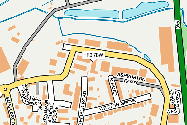
HR9 7BW is in Ashburton Industrial Estate, Ross-on-wye. HR9 7BW is located in the Ross East electoral ward, within the unitary authority of Herefordshire, County of and the English Parliamentary constituency of Hereford and South Herefordshire. The Sub Integrated Care Board (ICB) Location is NHS Herefordshire and Worcestershire ICB - 18C and the police force is West Mercia. This postcode has been in use since April 1985.


GetTheData
Source: OS OpenMap – Local (Ordnance Survey)
Source: OS VectorMap District (Ordnance Survey)
Licence: Open Government Licence (requires attribution)
| Easting | 360597 |
| Northing | 224369 |
| Latitude | 51.916445 |
| Longitude | -2.574292 |
GetTheData
Source: Open Postcode Geo
Licence: Open Government Licence
| Locality | Ashburton Industrial Estate |
| Town/City | Ross-on-wye |
| Country | England |
| Postcode District | HR9 |
➜ See where HR9 is on a map ➜ Where is Ross-on-Wye? | |
GetTheData
Source: Land Registry Price Paid Data
Licence: Open Government Licence
Elevation or altitude of HR9 7BW as distance above sea level:
| Metres | Feet | |
|---|---|---|
| Elevation | 40m | 131ft |
Elevation is measured from the approximate centre of the postcode, to the nearest point on an OS contour line from OS Terrain 50, which has contour spacing of ten vertical metres.
➜ How high above sea level am I? Find the elevation of your current position using your device's GPS.
GetTheData
Source: Open Postcode Elevation
Licence: Open Government Licence
| Ward | Ross East |
| Constituency | Hereford And South Herefordshire |
GetTheData
Source: ONS Postcode Database
Licence: Open Government Licence
UNIT 8, ASHBURTON INDUSTRIAL ESTATE, ROSS-ON-WYE, HR9 7BW 2006 1 AUG £420,000 |
GetTheData
Source: HM Land Registry Price Paid Data
Licence: Contains HM Land Registry data © Crown copyright and database right 2025. This data is licensed under the Open Government Licence v3.0.
| Camp Road (Gloucester Road) | Ross-on-wye | 257m |
| Camp Road (Gloucester Road) | Ross-on-wye | 262m |
| Wolf Business Park (Alton Road) | Ross-on-wye | 332m |
| Station Street | Ross-on-wye | 350m |
| Station Street | Ross-on-wye | 353m |
GetTheData
Source: NaPTAN
Licence: Open Government Licence
| Median download speed | 15.3Mbps |
| Average download speed | 23.4Mbps |
| Maximum download speed | 79.98Mbps |
| Median upload speed | 1.1Mbps |
| Average upload speed | 3.4Mbps |
| Maximum upload speed | 20.00Mbps |
GetTheData
Source: Ofcom
Licence: Ofcom Terms of Use (requires attribution)
Estimated total energy consumption in HR9 7BW by fuel type, 2015.
| Consumption (kWh) | 415,644 |
|---|---|
| Meter count | 22 |
| Mean (kWh/meter) | 18,893 |
| Median (kWh/meter) | 10,790 |
GetTheData
Source: Postcode level gas estimates: 2015 (experimental)
Source: Postcode level electricity estimates: 2015 (experimental)
Licence: Open Government Licence
GetTheData
Source: ONS Postcode Database
Licence: Open Government Licence


➜ Get more ratings from the Food Standards Agency
GetTheData
Source: Food Standards Agency
Licence: FSA terms & conditions
| Last Collection | |||
|---|---|---|---|
| Location | Mon-Fri | Sat | Distance |
| Smallbrook Road | 17:00 | 11:00 | 404m |
| Ross On Wye Sorting Office | 18:00 | 11:45 | 465m |
| The Maltings | 18:00 | 13:00 | 564m |
GetTheData
Source: Dracos
Licence: Creative Commons Attribution-ShareAlike
The below table lists the International Territorial Level (ITL) codes (formerly Nomenclature of Territorial Units for Statistics (NUTS) codes) and Local Administrative Units (LAU) codes for HR9 7BW:
| ITL 1 Code | Name |
|---|---|
| TLG | West Midlands (England) |
| ITL 2 Code | Name |
| TLG1 | Herefordshire, Worcestershire and Warwickshire |
| ITL 3 Code | Name |
| TLG11 | Herefordshire, County of |
| LAU 1 Code | Name |
| E06000019 | Herefordshire, County of |
GetTheData
Source: ONS Postcode Directory
Licence: Open Government Licence
The below table lists the Census Output Area (OA), Lower Layer Super Output Area (LSOA), and Middle Layer Super Output Area (MSOA) for HR9 7BW:
| Code | Name | |
|---|---|---|
| OA | E00071002 | |
| LSOA | E01014062 | Herefordshire 022B |
| MSOA | E02002926 | Herefordshire 022 |
GetTheData
Source: ONS Postcode Directory
Licence: Open Government Licence
| HR9 5DD | Ryefield Road | 54m |
| HR9 5LZ | North Road | 107m |
| HR9 5LS | Ryefield Road | 130m |
| HR9 5LU | Weston Grove | 146m |
| HR9 5LX | Penyard Villas | 170m |
| HR9 5LY | Mablethorpe Place | 179m |
| HR9 7QD | Grammar School Close | 216m |
| HR9 7AQ | Station Street | 228m |
| HR9 5PW | Gloucester Road | 231m |
| HR9 7QE | Beechwood | 234m |
GetTheData
Source: Open Postcode Geo; Land Registry Price Paid Data
Licence: Open Government Licence