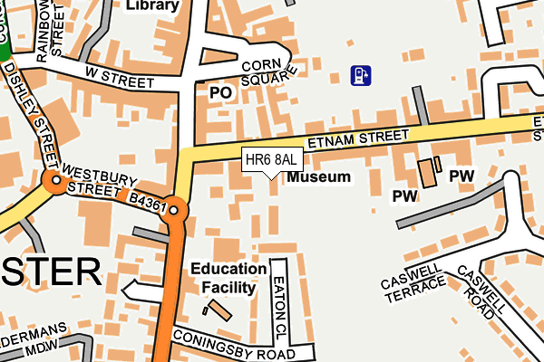
HR6 8AL is located in the Leominster East electoral ward, within the unitary authority of Herefordshire, County of and the English Parliamentary constituency of North Herefordshire. The Sub Integrated Care Board (ICB) Location is NHS Herefordshire and Worcestershire ICB - 18C and the police force is West Mercia. This postcode has been in use since January 1980.


GetTheData
Source: OS OpenMap – Local (Ordnance Survey)
Source: OS VectorMap District (Ordnance Survey)
Licence: Open Government Licence (requires attribution)
| Easting | 349716 |
| Northing | 258877 |
| Latitude | 52.225788 |
| Longitude | -2.737575 |
GetTheData
Source: Open Postcode Geo
Licence: Open Government Licence
| Country | England |
| Postcode District | HR6 |
➜ See where HR6 is on a map ➜ Where is Leominster? | |
GetTheData
Source: Land Registry Price Paid Data
Licence: Open Government Licence
Elevation or altitude of HR6 8AL as distance above sea level:
| Metres | Feet | |
|---|---|---|
| Elevation | 80m | 262ft |
Elevation is measured from the approximate centre of the postcode, to the nearest point on an OS contour line from OS Terrain 50, which has contour spacing of ten vertical metres.
➜ How high above sea level am I? Find the elevation of your current position using your device's GPS.
GetTheData
Source: Open Postcode Elevation
Licence: Open Government Licence
| Ward | Leominster East |
| Constituency | North Herefordshire |
GetTheData
Source: ONS Postcode Database
Licence: Open Government Licence
| Westbury Street | Leominster | 157m |
| Community Hospital (South Street) | Leominster | 236m |
| Community Hospital (South Street. Leominster) | Leominster | 298m |
| New Street | Leominster | 359m |
| Brook Hall (Broad Street) | Leominster | 383m |
| Leominster Station | 0.5km |
GetTheData
Source: NaPTAN
Licence: Open Government Licence
GetTheData
Source: ONS Postcode Database
Licence: Open Government Licence


➜ Get more ratings from the Food Standards Agency
GetTheData
Source: Food Standards Agency
Licence: FSA terms & conditions
| Last Collection | |||
|---|---|---|---|
| Location | Mon-Fri | Sat | Distance |
| Pinsley Road | 16:45 | 11:00 | 373m |
| Castlefields | 16:00 | 11:00 | 451m |
| The Mallards | 15:00 | 08:00 | 967m |
GetTheData
Source: Dracos
Licence: Creative Commons Attribution-ShareAlike
The below table lists the International Territorial Level (ITL) codes (formerly Nomenclature of Territorial Units for Statistics (NUTS) codes) and Local Administrative Units (LAU) codes for HR6 8AL:
| ITL 1 Code | Name |
|---|---|
| TLG | West Midlands (England) |
| ITL 2 Code | Name |
| TLG1 | Herefordshire, Worcestershire and Warwickshire |
| ITL 3 Code | Name |
| TLG11 | Herefordshire, County of |
| LAU 1 Code | Name |
| E06000019 | Herefordshire, County of |
GetTheData
Source: ONS Postcode Directory
Licence: Open Government Licence
The below table lists the Census Output Area (OA), Lower Layer Super Output Area (LSOA), and Middle Layer Super Output Area (MSOA) for HR6 8AL:
| Code | Name | |
|---|---|---|
| OA | E00070917 | |
| LSOA | E01014048 | Herefordshire 003D |
| MSOA | E02002907 | Herefordshire 003 |
GetTheData
Source: ONS Postcode Directory
Licence: Open Government Licence
| HR6 8AA | School Lane | 78m |
| HR6 8AQ | Etnam Street | 99m |
| HR6 8AB | Corn Square | 108m |
| HR6 8JA | South Street | 113m |
| HR6 8JB | Library Mews | 114m |
| HR6 8LX | Corn Street | 125m |
| HR6 8NR | The Nook | 136m |
| HR6 8JQ | South Street | 143m |
| HR6 8AE | Etnam Street | 145m |
| HR6 8LT | Corn Square | 150m |
GetTheData
Source: Open Postcode Geo; Land Registry Price Paid Data
Licence: Open Government Licence