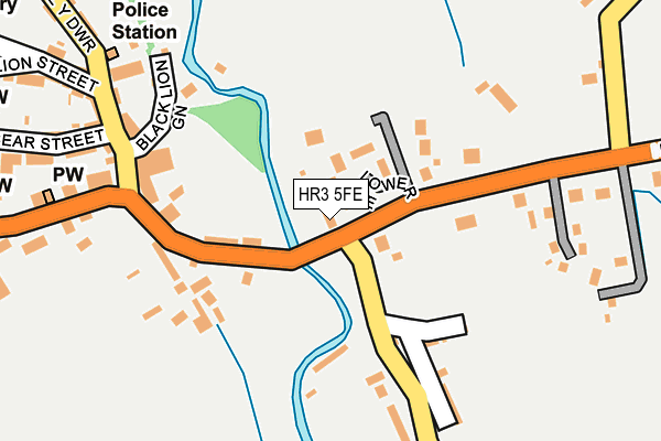
HR3 5FE is located in the Golden Valley North electoral ward, within the unitary authority of Herefordshire, County of and the English Parliamentary constituency of Hereford and South Herefordshire. The Sub Integrated Care Board (ICB) Location is NHS Herefordshire and Worcestershire ICB - 18C and the police force is West Mercia. This postcode has been in use since May 2013.


GetTheData
Source: OS OpenMap – Local (Ordnance Survey)
Source: OS VectorMap District (Ordnance Survey)
Licence: Open Government Licence (requires attribution)
| Easting | 323345 |
| Northing | 242280 |
| Latitude | 52.073565 |
| Longitude | -3.119835 |
GetTheData
Source: Open Postcode Geo
Licence: Open Government Licence
| Country | England |
| Postcode District | HR3 |
➜ See where HR3 is on a map ➜ Where is Hay-on-Wye? | |
GetTheData
Source: Land Registry Price Paid Data
Licence: Open Government Licence
Elevation or altitude of HR3 5FE as distance above sea level:
| Metres | Feet | |
|---|---|---|
| Elevation | 90m | 295ft |
Elevation is measured from the approximate centre of the postcode, to the nearest point on an OS contour line from OS Terrain 50, which has contour spacing of ten vertical metres.
➜ How high above sea level am I? Find the elevation of your current position using your device's GPS.
GetTheData
Source: Open Postcode Elevation
Licence: Open Government Licence
| Ward | Golden Valley North |
| Constituency | Hereford And South Herefordshire |
GetTheData
Source: ONS Postcode Database
Licence: Open Government Licence
| Lower Mead (B4348) | Cusop | 39m |
| Lower Mead (B4348) | Cusop | 51m |
| Nantyglasdwr Lane (B4348) | Cusop | 258m |
| Nantyglasdwr Lane (B4348) | Cusop | 261m |
| Hay Castle (Oxford Road) | Hay-on-wye | 376m |
GetTheData
Source: NaPTAN
Licence: Open Government Licence
GetTheData
Source: ONS Postcode Database
Licence: Open Government Licence


➜ Get more ratings from the Food Standards Agency
GetTheData
Source: Food Standards Agency
Licence: FSA terms & conditions
| Last Collection | |||
|---|---|---|---|
| Location | Mon-Fri | Sat | Distance |
| Church Street | 17:00 | 11:15 | 569m |
| Hay-on-wye Station | 17:15 | 11:15 | 572m |
| Aberllynfi | 10:00 | 10:00 | 2,733m |
GetTheData
Source: Dracos
Licence: Creative Commons Attribution-ShareAlike
The below table lists the International Territorial Level (ITL) codes (formerly Nomenclature of Territorial Units for Statistics (NUTS) codes) and Local Administrative Units (LAU) codes for HR3 5FE:
| ITL 1 Code | Name |
|---|---|
| TLG | West Midlands (England) |
| ITL 2 Code | Name |
| TLG1 | Herefordshire, Worcestershire and Warwickshire |
| ITL 3 Code | Name |
| TLG11 | Herefordshire, County of |
| LAU 1 Code | Name |
| E06000019 | Herefordshire, County of |
GetTheData
Source: ONS Postcode Directory
Licence: Open Government Licence
The below table lists the Census Output Area (OA), Lower Layer Super Output Area (LSOA), and Middle Layer Super Output Area (MSOA) for HR3 5FE:
| Code | Name | |
|---|---|---|
| OA | E00070771 | |
| LSOA | E01014018 | Herefordshire 020A |
| MSOA | E02002924 | Herefordshire 020 |
GetTheData
Source: ONS Postcode Directory
Licence: Open Government Licence
| HR3 5RW | Lower Mead | 70m |
| HR3 5AP | Albion Terrace | 99m |
| HR3 5QZ | The Crescent | 144m |
| HR3 5AW | Garribaldi Terrace | 150m |
| HR3 5RA | Grove Cottages | 159m |
| HR3 5AD | Lion Street | 180m |
| HR3 5AR | 193m | |
| HR3 5RB | Victoria Terrace | 198m |
| HR3 5QX | 199m | |
| HR3 5BW | Oxford Villas | 209m |
GetTheData
Source: Open Postcode Geo; Land Registry Price Paid Data
Licence: Open Government Licence