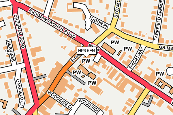
HP6 5EN lies on Sycamore Road in Amersham. HP6 5EN is located in the Amersham and Chesham Bois electoral ward, within the unitary authority of Buckinghamshire and the English Parliamentary constituency of Chesham and Amersham. The Sub Integrated Care Board (ICB) Location is NHS Buckinghamshire, Oxfordshire and Berkshire West ICB - 14Y and the police force is Thames Valley. This postcode has been in use since January 1980.


GetTheData
Source: OS OpenMap – Local (Ordnance Survey)
Source: OS VectorMap District (Ordnance Survey)
Licence: Open Government Licence (requires attribution)
| Easting | 496550 |
| Northing | 198656 |
| Latitude | 51.678381 |
| Longitude | -0.604995 |
GetTheData
Source: Open Postcode Geo
Licence: Open Government Licence
| Street | Sycamore Road |
| Town/City | Amersham |
| Country | England |
| Postcode District | HP6 |
➜ See where HP6 is on a map ➜ Where is Amersham? | |
GetTheData
Source: Land Registry Price Paid Data
Licence: Open Government Licence
Elevation or altitude of HP6 5EN as distance above sea level:
| Metres | Feet | |
|---|---|---|
| Elevation | 160m | 525ft |
Elevation is measured from the approximate centre of the postcode, to the nearest point on an OS contour line from OS Terrain 50, which has contour spacing of ten vertical metres.
➜ How high above sea level am I? Find the elevation of your current position using your device's GPS.
GetTheData
Source: Open Postcode Elevation
Licence: Open Government Licence
| Ward | Amersham And Chesham Bois |
| Constituency | Chesham And Amersham |
GetTheData
Source: ONS Postcode Database
Licence: Open Government Licence
| Sycamore Road | Amersham | 63m |
| Sycamore Road | Amersham | 70m |
| Rickmansworth Road | Amersham | 73m |
| Rickmansworth Road | Amersham | 82m |
| Leisure Centre (Chiltern Avenue) | Amersham | 247m |
| Amersham Underground Station | Amersham | 509m |
| Amersham Station | 0.5km |
| Chalfont & Latimer Station | 3.3km |
GetTheData
Source: NaPTAN
Licence: Open Government Licence
GetTheData
Source: ONS Postcode Database
Licence: Open Government Licence


➜ Get more ratings from the Food Standards Agency
GetTheData
Source: Food Standards Agency
Licence: FSA terms & conditions
| Last Collection | |||
|---|---|---|---|
| Location | Mon-Fri | Sat | Distance |
| Sycomore Road | 17:45 | 12:30 | 29m |
| Boot And Slipper | 18:10 | 11:45 | 339m |
| Amersham Delivery Office | 18:15 | 12:30 | 373m |
GetTheData
Source: Dracos
Licence: Creative Commons Attribution-ShareAlike
The below table lists the International Territorial Level (ITL) codes (formerly Nomenclature of Territorial Units for Statistics (NUTS) codes) and Local Administrative Units (LAU) codes for HP6 5EN:
| ITL 1 Code | Name |
|---|---|
| TLJ | South East (England) |
| ITL 2 Code | Name |
| TLJ1 | Berkshire, Buckinghamshire and Oxfordshire |
| ITL 3 Code | Name |
| TLJ13 | Buckinghamshire |
| LAU 1 Code | Name |
| E06000060 | Buckinghamshire |
GetTheData
Source: ONS Postcode Directory
Licence: Open Government Licence
The below table lists the Census Output Area (OA), Lower Layer Super Output Area (LSOA), and Middle Layer Super Output Area (MSOA) for HP6 5EN:
| Code | Name | |
|---|---|---|
| OA | E00089521 | |
| LSOA | E01017742 | Chiltern 006B |
| MSOA | E02003681 | Chiltern 006 |
GetTheData
Source: ONS Postcode Directory
Licence: Open Government Licence
| HP6 5EJ | Sycamore Road | 49m |
| HP6 6AG | Woodside Road | 71m |
| HP6 5JW | Rickmansworth Road | 101m |
| HP6 5HQ | The Burren | 105m |
| HP6 5EL | Grimsdells Corner | 115m |
| HP6 5HP | Chiltern Parade | 123m |
| HP6 5DR | Sycamore Road | 128m |
| HP6 6AA | Woodside Road | 128m |
| HP6 6AD | Woodside Road | 138m |
| HP6 6HE | Grimsdells Lane | 144m |
GetTheData
Source: Open Postcode Geo; Land Registry Price Paid Data
Licence: Open Government Licence