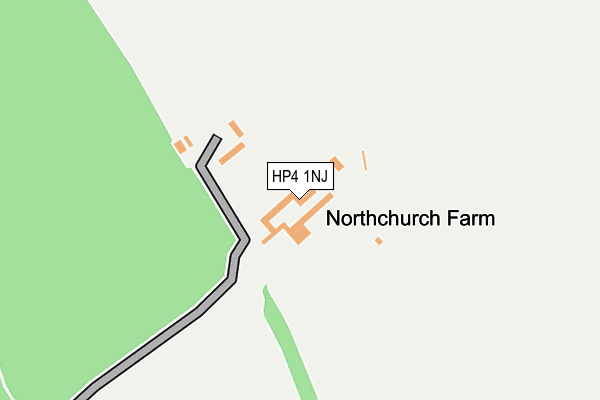
HP4 1NJ is located in the Northchurch electoral ward, within the local authority district of Dacorum and the English Parliamentary constituency of South West Hertfordshire. The Sub Integrated Care Board (ICB) Location is NHS Hertfordshire and West Essex ICB - 06N and the police force is Hertfordshire. This postcode has been in use since July 1990.


GetTheData
Source: OS OpenMap – Local (Ordnance Survey)
Source: OS VectorMap District (Ordnance Survey)
Licence: Open Government Licence (requires attribution)
| Easting | 497493 |
| Northing | 209347 |
| Latitude | 51.774321 |
| Longitude | -0.588347 |
GetTheData
Source: Open Postcode Geo
Licence: Open Government Licence
| Country | England |
| Postcode District | HP4 |
➜ See where HP4 is on a map | |
GetTheData
Source: Land Registry Price Paid Data
Licence: Open Government Licence
Elevation or altitude of HP4 1NJ as distance above sea level:
| Metres | Feet | |
|---|---|---|
| Elevation | 170m | 558ft |
Elevation is measured from the approximate centre of the postcode, to the nearest point on an OS contour line from OS Terrain 50, which has contour spacing of ten vertical metres.
➜ How high above sea level am I? Find the elevation of your current position using your device's GPS.
GetTheData
Source: Open Postcode Elevation
Licence: Open Government Licence
| Ward | Northchurch |
| Constituency | South West Hertfordshire |
GetTheData
Source: ONS Postcode Database
Licence: Open Government Licence
| Alyngton (Mandelyns) | Northchurch | 237m |
| Woodside Cottage (New Road) | Northchurch | 365m |
| Woodside Cottage (New Road) | Northchurch | 371m |
| Emperor Close (Spring Field Road) | Berkhamsted | 459m |
| Darr's Lane (High Street) | Northchurch | 469m |
| Berkhamsted Station | 2.2km |
| Tring Station | 3.8km |
GetTheData
Source: NaPTAN
Licence: Open Government Licence
GetTheData
Source: ONS Postcode Database
Licence: Open Government Licence


➜ Get more ratings from the Food Standards Agency
GetTheData
Source: Food Standards Agency
Licence: FSA terms & conditions
| Last Collection | |||
|---|---|---|---|
| Location | Mon-Fri | Sat | Distance |
| Springwood | 17:15 | 11:30 | 264m |
| Springfield Road | 17:15 | 11:30 | 416m |
| Northchurch P.o. | 17:15 | 11:30 | 502m |
GetTheData
Source: Dracos
Licence: Creative Commons Attribution-ShareAlike
The below table lists the International Territorial Level (ITL) codes (formerly Nomenclature of Territorial Units for Statistics (NUTS) codes) and Local Administrative Units (LAU) codes for HP4 1NJ:
| ITL 1 Code | Name |
|---|---|
| TLH | East |
| ITL 2 Code | Name |
| TLH2 | Bedfordshire and Hertfordshire |
| ITL 3 Code | Name |
| TLH23 | Hertfordshire CC |
| LAU 1 Code | Name |
| E07000096 | Dacorum |
GetTheData
Source: ONS Postcode Directory
Licence: Open Government Licence
The below table lists the Census Output Area (OA), Lower Layer Super Output Area (LSOA), and Middle Layer Super Output Area (MSOA) for HP4 1NJ:
| Code | Name | |
|---|---|---|
| OA | E00118951 | |
| LSOA | E01023416 | Dacorum 006C |
| MSOA | E02004861 | Dacorum 006 |
GetTheData
Source: ONS Postcode Directory
Licence: Open Government Licence
| HP4 3XL | Emerton Court | 184m |
| HP4 3XH | Mandelyns | 227m |
| HP4 3XJ | Emerton Garth | 243m |
| HP4 3XP | Alyngton | 276m |
| HP4 3XN | Brakynbery | 294m |
| HP4 1LN | New Road | 300m |
| HP4 1LP | New Road | 305m |
| HP4 1FN | Cowslip Meadow | 306m |
| HP4 1LW | Bridgewater Hill | 329m |
| HP4 3XE | Friars Field | 349m |
GetTheData
Source: Open Postcode Geo; Land Registry Price Paid Data
Licence: Open Government Licence