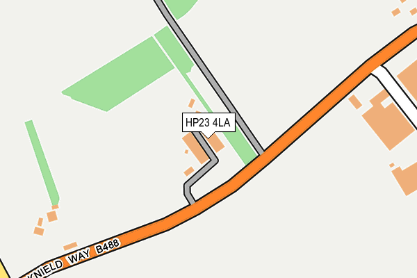
HP23 4LA lies on Icknield Way in Tring. HP23 4LA is located in the Aston Clinton and Bierton electoral ward, within the unitary authority of Buckinghamshire and the English Parliamentary constituency of Aylesbury. The Sub Integrated Care Board (ICB) Location is NHS Buckinghamshire, Oxfordshire and Berkshire West ICB - 14Y and the police force is Thames Valley. This postcode has been in use since January 1980.


GetTheData
Source: OS OpenMap – Local (Ordnance Survey)
Source: OS VectorMap District (Ordnance Survey)
Licence: Open Government Licence (requires attribution)
| Easting | 490904 |
| Northing | 211498 |
| Latitude | 51.794763 |
| Longitude | -0.683253 |
GetTheData
Source: Open Postcode Geo
Licence: Open Government Licence
| Street | Icknield Way |
| Town/City | Tring |
| Country | England |
| Postcode District | HP23 |
➜ See where HP23 is on a map ➜ Where is Tring? | |
GetTheData
Source: Land Registry Price Paid Data
Licence: Open Government Licence
Elevation or altitude of HP23 4LA as distance above sea level:
| Metres | Feet | |
|---|---|---|
| Elevation | 160m | 525ft |
Elevation is measured from the approximate centre of the postcode, to the nearest point on an OS contour line from OS Terrain 50, which has contour spacing of ten vertical metres.
➜ How high above sea level am I? Find the elevation of your current position using your device's GPS.
GetTheData
Source: Open Postcode Elevation
Licence: Open Government Licence
| Ward | Aston Clinton And Bierton |
| Constituency | Aylesbury |
GetTheData
Source: ONS Postcode Database
Licence: Open Government Licence
| Drayton Manor Lodge (Aylesbury Road) | Tring | 442m |
| Drayton Manor Lodge (Aylesbury Road) | Tring | 451m |
| Highfield Road (Miswell Lane) | Tring | 697m |
| Highfield Road (Miswell Lane) | Tring | 700m |
| Longfield Road (Aylesbury Road) | Tring | 723m |
| Tring Station | 4.2km |
| Wendover Station | 5.7km |
GetTheData
Source: NaPTAN
Licence: Open Government Licence
| Percentage of properties with Next Generation Access | 100.0% |
| Percentage of properties with Superfast Broadband | 0.0% |
| Percentage of properties with Ultrafast Broadband | 0.0% |
| Percentage of properties with Full Fibre Broadband | 0.0% |
Superfast Broadband is between 30Mbps and 300Mbps
Ultrafast Broadband is > 300Mbps
| Percentage of properties unable to receive 2Mbps | 0.0% |
| Percentage of properties unable to receive 5Mbps | 0.0% |
| Percentage of properties unable to receive 10Mbps | 0.0% |
| Percentage of properties unable to receive 30Mbps | 100.0% |
GetTheData
Source: Ofcom
Licence: Ofcom Terms of Use (requires attribution)
GetTheData
Source: ONS Postcode Database
Licence: Open Government Licence


➜ Get more ratings from the Food Standards Agency
GetTheData
Source: Food Standards Agency
Licence: FSA terms & conditions
| Last Collection | |||
|---|---|---|---|
| Location | Mon-Fri | Sat | Distance |
| Beaconsfield Road | 17:15 | 11:00 | 428m |
| Tring Hill | 15:30 | 07:00 | 595m |
| Buckingham Road | 17:30 | 11:00 | 645m |
GetTheData
Source: Dracos
Licence: Creative Commons Attribution-ShareAlike
The below table lists the International Territorial Level (ITL) codes (formerly Nomenclature of Territorial Units for Statistics (NUTS) codes) and Local Administrative Units (LAU) codes for HP23 4LA:
| ITL 1 Code | Name |
|---|---|
| TLJ | South East (England) |
| ITL 2 Code | Name |
| TLJ1 | Berkshire, Buckinghamshire and Oxfordshire |
| ITL 3 Code | Name |
| TLJ13 | Buckinghamshire |
| LAU 1 Code | Name |
| E06000060 | Buckinghamshire |
GetTheData
Source: ONS Postcode Directory
Licence: Open Government Licence
The below table lists the Census Output Area (OA), Lower Layer Super Output Area (LSOA), and Middle Layer Super Output Area (MSOA) for HP23 4LA:
| Code | Name | |
|---|---|---|
| OA | E00088988 | |
| LSOA | E01017629 | Aylesbury Vale 021C |
| MSOA | E02003672 | Aylesbury Vale 021 |
GetTheData
Source: ONS Postcode Directory
Licence: Open Government Licence
| HP23 4JY | Icknield Way Industrial Estate | 237m |
| HP23 4HD | Okeley Lane | 342m |
| HP23 4LB | Icknield Way | 355m |
| HP23 4HB | Okeley Lane | 371m |
| HP23 4HF | Buckingham Road | 402m |
| HP23 4HE | Okeley Lane | 421m |
| HP23 4DT | Fairthorn Close | 445m |
| HP23 4HA | Anns Close | 454m |
| HP23 4DU | Acacia Walk | 496m |
| HP23 4DS | Highfield Road | 509m |
GetTheData
Source: Open Postcode Geo; Land Registry Price Paid Data
Licence: Open Government Licence