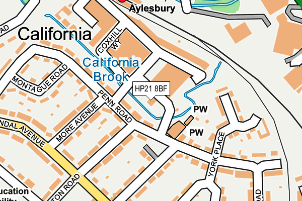
HP21 8BF is located in the Aylesbury South West electoral ward, within the unitary authority of Buckinghamshire and the English Parliamentary constituency of Aylesbury. The Sub Integrated Care Board (ICB) Location is NHS Buckinghamshire, Oxfordshire and Berkshire West ICB - 14Y and the police force is Thames Valley. This postcode has been in use since July 2017.


GetTheData
Source: OS OpenMap – Local (Ordnance Survey)
Source: OS VectorMap District (Ordnance Survey)
Licence: Open Government Licence (requires attribution)
| Easting | 481856 |
| Northing | 213240 |
| Latitude | 51.811817 |
| Longitude | -0.814011 |
GetTheData
Source: Open Postcode Geo
Licence: Open Government Licence
| Country | England |
| Postcode District | HP21 |
➜ See where HP21 is on a map ➜ Where is Aylesbury? | |
GetTheData
Source: Land Registry Price Paid Data
Licence: Open Government Licence
| Ward | Aylesbury South West |
| Constituency | Aylesbury |
GetTheData
Source: ONS Postcode Database
Licence: Open Government Licence
| Hampden Road (Prebendal Avenue) | Southcourt | 228m |
| Hampden Road (Prebendal Avenue) | Southcourt | 232m |
| Railway Station (Station Forecourt) | Aylesbury | 251m |
| Railway Station (Station Way) | Aylesbury | 284m |
| Penn Road (Prebendal Avenue) | Southcourt | 313m |
| Aylesbury Station | 0.2km |
| Stoke Mandeville Station | 3.4km |
| Aylesbury Vale Parkway Station | 3.8km |
GetTheData
Source: NaPTAN
Licence: Open Government Licence
GetTheData
Source: ONS Postcode Database
Licence: Open Government Licence


➜ Get more ratings from the Food Standards Agency
GetTheData
Source: Food Standards Agency
Licence: FSA terms & conditions
| Last Collection | |||
|---|---|---|---|
| Location | Mon-Fri | Sat | Distance |
| Southcourt P.o. | 17:15 | 12:00 | 91m |
| Station | 17:30 | 12:00 | 241m |
| Prebendal Ave | 17:00 | 12:00 | 359m |
GetTheData
Source: Dracos
Licence: Creative Commons Attribution-ShareAlike
| Risk of HP21 8BF flooding from rivers and sea | Very Low |
| ➜ HP21 8BF flood map | |
GetTheData
Source: Open Flood Risk by Postcode
Licence: Open Government Licence
The below table lists the International Territorial Level (ITL) codes (formerly Nomenclature of Territorial Units for Statistics (NUTS) codes) and Local Administrative Units (LAU) codes for HP21 8BF:
| ITL 1 Code | Name |
|---|---|
| TLJ | South East (England) |
| ITL 2 Code | Name |
| TLJ1 | Berkshire, Buckinghamshire and Oxfordshire |
| ITL 3 Code | Name |
| TLJ13 | Buckinghamshire |
| LAU 1 Code | Name |
| E06000060 | Buckinghamshire |
GetTheData
Source: ONS Postcode Directory
Licence: Open Government Licence
The below table lists the Census Output Area (OA), Lower Layer Super Output Area (LSOA), and Middle Layer Super Output Area (MSOA) for HP21 8BF:
| Code | Name | |
|---|---|---|
| OA | E00169109 | |
| LSOA | E01017712 | Aylesbury Vale 018D |
| MSOA | E02003669 | Aylesbury Vale 018 |
GetTheData
Source: ONS Postcode Directory
Licence: Open Government Licence
| HP21 8HN | Penn Road | 40m |
| HP21 8FH | Coxhill Way | 74m |
| HP21 8FJ | Coxhill Way | 87m |
| HP21 8JZ | Penn Road | 90m |
| HP21 8FW | Coxhill Way | 112m |
| HP21 8FL | Coxhill Way | 130m |
| HP21 8FQ | Coxhill Way | 134m |
| HP21 8LA | Eaton Road | 138m |
| HP21 8GZ | York Place | 141m |
| HP21 8JJ | Hampden Road | 142m |
GetTheData
Source: Open Postcode Geo; Land Registry Price Paid Data
Licence: Open Government Licence