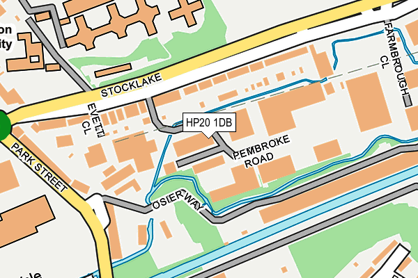
HP20 1DB is located in the Aylesbury East electoral ward, within the unitary authority of Buckinghamshire and the English Parliamentary constituency of Aylesbury. The Sub Integrated Care Board (ICB) Location is NHS Buckinghamshire, Oxfordshire and Berkshire West ICB - 14Y and the police force is Thames Valley. This postcode has been in use since January 1980.


GetTheData
Source: OS OpenMap – Local (Ordnance Survey)
Source: OS VectorMap District (Ordnance Survey)
Licence: Open Government Licence (requires attribution)
| Easting | 482841 |
| Northing | 214024 |
| Latitude | 51.818720 |
| Longitude | -0.799538 |
GetTheData
Source: Open Postcode Geo
Licence: Open Government Licence
| Country | England |
| Postcode District | HP20 |
➜ See where HP20 is on a map ➜ Where is Aylesbury? | |
GetTheData
Source: Land Registry Price Paid Data
Licence: Open Government Licence
Elevation or altitude of HP20 1DB as distance above sea level:
| Metres | Feet | |
|---|---|---|
| Elevation | 80m | 262ft |
Elevation is measured from the approximate centre of the postcode, to the nearest point on an OS contour line from OS Terrain 50, which has contour spacing of ten vertical metres.
➜ How high above sea level am I? Find the elevation of your current position using your device's GPS.
GetTheData
Source: Open Postcode Elevation
Licence: Open Government Licence
| Ward | Aylesbury East |
| Constituency | Aylesbury |
GetTheData
Source: ONS Postcode Database
Licence: Open Government Licence
| Tring Road Tesco (Tring Road) | Aylesbury | 352m |
| Tring Road Tesco (Tring Road) | Aylesbury | 399m |
| Tring Road Tesco (High Street) | Aylesbury | 424m |
| Tring Road Cemetery (Tring Road) | Aylesbury | 424m |
| Tring Road Cemetery (Tring Road) | Aylesbury | 433m |
| Aylesbury Station | 1.2km |
| Stoke Mandeville Station | 3.6km |
| Aylesbury Vale Parkway Station | 4.4km |
GetTheData
Source: NaPTAN
Licence: Open Government Licence
Estimated total energy consumption in HP20 1DB by fuel type, 2015.
| Consumption (kWh) | 30,454 |
|---|---|
| Meter count | 7 |
| Mean (kWh/meter) | 4,351 |
| Median (kWh/meter) | 9 |
GetTheData
Source: Postcode level gas estimates: 2015 (experimental)
Source: Postcode level electricity estimates: 2015 (experimental)
Licence: Open Government Licence
GetTheData
Source: ONS Postcode Database
Licence: Open Government Licence


➜ Get more ratings from the Food Standards Agency
GetTheData
Source: Food Standards Agency
Licence: FSA terms & conditions
| Last Collection | |||
|---|---|---|---|
| Location | Mon-Fri | Sat | Distance |
| Park Street | 17:00 | 12:00 | 325m |
| Printing Works | 17:00 | 12:00 | 402m |
| Hm Prison | 17:15 | 12:00 | 458m |
GetTheData
Source: Dracos
Licence: Creative Commons Attribution-ShareAlike
| Risk of HP20 1DB flooding from rivers and sea | Low |
| ➜ HP20 1DB flood map | |
GetTheData
Source: Open Flood Risk by Postcode
Licence: Open Government Licence
The below table lists the International Territorial Level (ITL) codes (formerly Nomenclature of Territorial Units for Statistics (NUTS) codes) and Local Administrative Units (LAU) codes for HP20 1DB:
| ITL 1 Code | Name |
|---|---|
| TLJ | South East (England) |
| ITL 2 Code | Name |
| TLJ1 | Berkshire, Buckinghamshire and Oxfordshire |
| ITL 3 Code | Name |
| TLJ13 | Buckinghamshire |
| LAU 1 Code | Name |
| E06000060 | Buckinghamshire |
GetTheData
Source: ONS Postcode Directory
Licence: Open Government Licence
The below table lists the Census Output Area (OA), Lower Layer Super Output Area (LSOA), and Middle Layer Super Output Area (MSOA) for HP20 1DB:
| Code | Name | |
|---|---|---|
| OA | E00169122 | |
| LSOA | E01017699 | Aylesbury Vale 014C |
| MSOA | E02003665 | Aylesbury Vale 014 |
GetTheData
Source: ONS Postcode Directory
Licence: Open Government Licence
| HP20 1DA | Stocklake | 82m |
| HP20 1EB | Park Street Industrial Estate | 205m |
| HP20 1AT | Stocklake | 206m |
| HP20 1DN | Stocklake | 217m |
| HP20 1DX | Park Street | 230m |
| HP20 1DU | Park Street | 278m |
| HP20 1LZ | Victoria Street | 286m |
| HP20 1NA | Victoria Street | 315m |
| HP20 1RY | Florey Gardens | 334m |
| HP20 1LY | Albert Street | 355m |
GetTheData
Source: Open Postcode Geo; Land Registry Price Paid Data
Licence: Open Government Licence