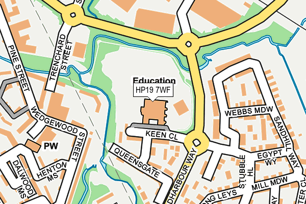
HP19 7WF is located in the Aylesbury West electoral ward, within the unitary authority of Buckinghamshire and the English Parliamentary constituency of Aylesbury. The Sub Integrated Care Board (ICB) Location is NHS Buckinghamshire, Oxfordshire and Berkshire West ICB - 14Y and the police force is Thames Valley. This postcode has been in use since December 2000.


GetTheData
Source: OS OpenMap – Local (Ordnance Survey)
Source: OS VectorMap District (Ordnance Survey)
Licence: Open Government Licence (requires attribution)
| Easting | 480289 |
| Northing | 213852 |
| Latitude | 51.817545 |
| Longitude | -0.836595 |
GetTheData
Source: Open Postcode Geo
Licence: Open Government Licence
| Country | England |
| Postcode District | HP19 |
➜ See where HP19 is on a map ➜ Where is Aylesbury? | |
GetTheData
Source: Land Registry Price Paid Data
Licence: Open Government Licence
Elevation or altitude of HP19 7WF as distance above sea level:
| Metres | Feet | |
|---|---|---|
| Elevation | 70m | 230ft |
Elevation is measured from the approximate centre of the postcode, to the nearest point on an OS contour line from OS Terrain 50, which has contour spacing of ten vertical metres.
➜ How high above sea level am I? Find the elevation of your current position using your device's GPS.
GetTheData
Source: Open Postcode Elevation
Licence: Open Government Licence
| Ward | Aylesbury West |
| Constituency | Aylesbury |
GetTheData
Source: ONS Postcode Database
Licence: Open Government Licence
| Griffin Lane Roundabout (Coldharbour Way) | Fairford Leys | 90m |
| Griffin Lane Roundabout (Coldharbour Way) | Fairford Leys | 101m |
| St Mary's School (Coldharbour Way) | Fairford Leys | 140m |
| St Mary's School (Coldharbour Way) | Fairford Leys | 154m |
| Hampden Square (Wedgewood Street) | Fairford Leys | 188m |
| Aylesbury Station | 1.5km |
| Aylesbury Vale Parkway Station | 2.2km |
| Stoke Mandeville Station | 4.9km |
GetTheData
Source: NaPTAN
Licence: Open Government Licence
GetTheData
Source: ONS Postcode Database
Licence: Open Government Licence


➜ Get more ratings from the Food Standards Agency
GetTheData
Source: Food Standards Agency
Licence: FSA terms & conditions
| Last Collection | |||
|---|---|---|---|
| Location | Mon-Fri | Sat | Distance |
| Keen Close | 16:00 | 12:00 | 63m |
| Hampden Square | 17:00 | 12:00 | 206m |
| Pottery Close | 17:00 | 12:00 | 444m |
GetTheData
Source: Dracos
Licence: Creative Commons Attribution-ShareAlike
| Risk of HP19 7WF flooding from rivers and sea | Medium |
| ➜ HP19 7WF flood map | |
GetTheData
Source: Open Flood Risk by Postcode
Licence: Open Government Licence
The below table lists the International Territorial Level (ITL) codes (formerly Nomenclature of Territorial Units for Statistics (NUTS) codes) and Local Administrative Units (LAU) codes for HP19 7WF:
| ITL 1 Code | Name |
|---|---|
| TLJ | South East (England) |
| ITL 2 Code | Name |
| TLJ1 | Berkshire, Buckinghamshire and Oxfordshire |
| ITL 3 Code | Name |
| TLJ13 | Buckinghamshire |
| LAU 1 Code | Name |
| E06000060 | Buckinghamshire |
GetTheData
Source: ONS Postcode Directory
Licence: Open Government Licence
The below table lists the Census Output Area (OA), Lower Layer Super Output Area (LSOA), and Middle Layer Super Output Area (MSOA) for HP19 7WF:
| Code | Name | |
|---|---|---|
| OA | E00169135 | |
| LSOA | E01032957 | Aylesbury Vale 016F |
| MSOA | E02003667 | Aylesbury Vale 016 |
GetTheData
Source: ONS Postcode Directory
Licence: Open Government Licence
| HP19 7WE | Keen Close | 76m |
| HP19 7WH | Somers Lees | 90m |
| HP19 7WB | Queensgate | 119m |
| HP19 7WA | Queensgate | 171m |
| HP19 8GR | Standfield Close | 181m |
| HP19 8GU | Sandhill Way | 184m |
| HP19 7HL | Wedgewood Street | 185m |
| HP19 7WD | Astronomy Way | 187m |
| HP19 7AA | Trenchard Street | 197m |
| HP19 8GT | Webbs Meadow | 200m |
GetTheData
Source: Open Postcode Geo; Land Registry Price Paid Data
Licence: Open Government Licence