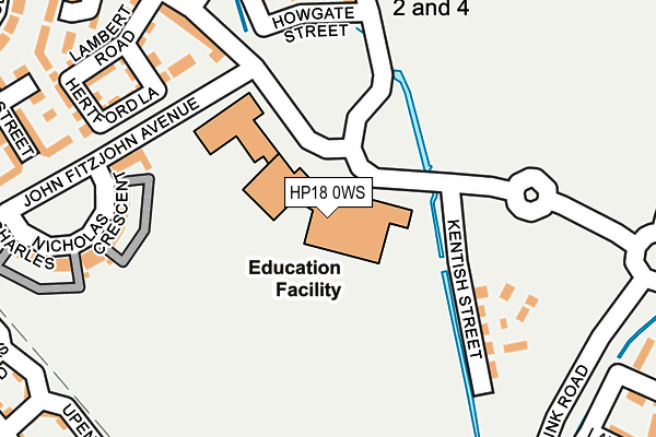
HP18 0WS is located in the Stone and Waddesdon electoral ward, within the unitary authority of Buckinghamshire and the English Parliamentary constituency of Aylesbury. The Sub Integrated Care Board (ICB) Location is NHS Buckinghamshire, Oxfordshire and Berkshire West ICB - 14Y and the police force is Thames Valley. This postcode has been in use since August 2013.


GetTheData
Source: OS OpenMap – Local (Ordnance Survey)
Source: OS VectorMap District (Ordnance Survey)
Licence: Open Government Licence (requires attribution)
| Easting | 479107 |
| Northing | 215788 |
| Latitude | 51.835110 |
| Longitude | -0.853319 |
GetTheData
Source: Open Postcode Geo
Licence: Open Government Licence
| Country | England |
| Postcode District | HP18 |
➜ See where HP18 is on a map ➜ Where is Aylesbury? | |
GetTheData
Source: Land Registry Price Paid Data
Licence: Open Government Licence
Elevation or altitude of HP18 0WS as distance above sea level:
| Metres | Feet | |
|---|---|---|
| Elevation | 80m | 262ft |
Elevation is measured from the approximate centre of the postcode, to the nearest point on an OS contour line from OS Terrain 50, which has contour spacing of ten vertical metres.
➜ How high above sea level am I? Find the elevation of your current position using your device's GPS.
GetTheData
Source: Open Postcode Elevation
Licence: Open Government Licence
| Ward | Stone And Waddesdon |
| Constituency | Aylesbury |
GetTheData
Source: ONS Postcode Database
Licence: Open Government Licence
| Vale Academy (Berryfields Lane) | Berryfields | 66m |
| Vale Academy (Berryfields Lane) | Berryfields | 96m |
| Ava Parking (Berryfields Lane) | Berryfields | 111m |
| John Fitzjohn Way | Berryfields | 245m |
| John Fitzjohn Way | Berryfields | 250m |
| Aylesbury Vale Parkway Station | 0.6km |
| Aylesbury Station | 3.5km |
GetTheData
Source: NaPTAN
Licence: Open Government Licence
GetTheData
Source: ONS Postcode Database
Licence: Open Government Licence


➜ Get more ratings from the Food Standards Agency
GetTheData
Source: Food Standards Agency
Licence: FSA terms & conditions
| Last Collection | |||
|---|---|---|---|
| Location | Mon-Fri | Sat | Distance |
| Woodford Close | 17:30 | 12:00 | 467m |
| Jackson Road | 17:15 | 12:00 | 1,062m |
| Picasso Place | 17:15 | 12:00 | 1,081m |
GetTheData
Source: Dracos
Licence: Creative Commons Attribution-ShareAlike
The below table lists the International Territorial Level (ITL) codes (formerly Nomenclature of Territorial Units for Statistics (NUTS) codes) and Local Administrative Units (LAU) codes for HP18 0WS:
| ITL 1 Code | Name |
|---|---|
| TLJ | South East (England) |
| ITL 2 Code | Name |
| TLJ1 | Berkshire, Buckinghamshire and Oxfordshire |
| ITL 3 Code | Name |
| TLJ13 | Buckinghamshire |
| LAU 1 Code | Name |
| E06000060 | Buckinghamshire |
GetTheData
Source: ONS Postcode Directory
Licence: Open Government Licence
The below table lists the Census Output Area (OA), Lower Layer Super Output Area (LSOA), and Middle Layer Super Output Area (MSOA) for HP18 0WS:
| Code | Name | |
|---|---|---|
| OA | E00089351 | |
| LSOA | E01017705 | Aylesbury Vale 012A |
| MSOA | E02003663 | Aylesbury Vale 012 |
GetTheData
Source: ONS Postcode Directory
Licence: Open Government Licence
| HP18 0PT | Quarrendon | 68m |
| HP18 0GU | Nicholas Charles Crescent | 217m |
| HP18 0WU | Lambert Road | 237m |
| HP18 0WY | Hertford Lane | 240m |
| HP18 0UP | Collington Road | 276m |
| HP18 0QR | Keswick Street | 291m |
| HP18 0FU | Alma Street | 292m |
| HP18 0HZ | Morgan Drive | 292m |
| HP18 0WT | Morello Close | 305m |
| HP18 0UW | Lawson Way | 310m |
GetTheData
Source: Open Postcode Geo; Land Registry Price Paid Data
Licence: Open Government Licence