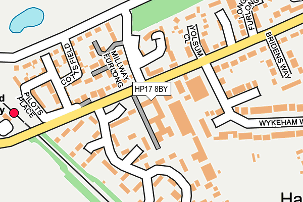
HP17 8BY lies on Thame Road in Haddenham, Aylesbury. HP17 8BY is located in the Bernwood electoral ward, within the unitary authority of Buckinghamshire and the English Parliamentary constituency of Buckingham. The Sub Integrated Care Board (ICB) Location is NHS Buckinghamshire, Oxfordshire and Berkshire West ICB - 14Y and the police force is Thames Valley. This postcode has been in use since January 1980.


GetTheData
Source: OS OpenMap – Local (Ordnance Survey)
Source: OS VectorMap District (Ordnance Survey)
Licence: Open Government Licence (requires attribution)
| Easting | 473432 |
| Northing | 208573 |
| Latitude | 51.771030 |
| Longitude | -0.937169 |
GetTheData
Source: Open Postcode Geo
Licence: Open Government Licence
| Street | Thame Road |
| Locality | Haddenham |
| Town/City | Aylesbury |
| Country | England |
| Postcode District | HP17 |
➜ See where HP17 is on a map ➜ Where is Haddenham? | |
GetTheData
Source: Land Registry Price Paid Data
Licence: Open Government Licence
Elevation or altitude of HP17 8BY as distance above sea level:
| Metres | Feet | |
|---|---|---|
| Elevation | 80m | 262ft |
Elevation is measured from the approximate centre of the postcode, to the nearest point on an OS contour line from OS Terrain 50, which has contour spacing of ten vertical metres.
➜ How high above sea level am I? Find the elevation of your current position using your device's GPS.
GetTheData
Source: Open Postcode Elevation
Licence: Open Government Licence
| Ward | Bernwood |
| Constituency | Buckingham |
GetTheData
Source: ONS Postcode Database
Licence: Open Government Licence
CHILTERN HOUSE, THAME ROAD, HADDENHAM, AYLESBURY, HP17 8BY 2003 31 JAN £580,000 |
GetTheData
Source: HM Land Registry Price Paid Data
Licence: Contains HM Land Registry data © Crown copyright and database right 2025. This data is licensed under the Open Government Licence v3.0.
| Briden's Way (Thame Road) | Haddenham | 235m |
| Station Bridge (Thame Road) | Haddenham | 263m |
| Station Bridge (Thame Road) | Haddenham | 268m |
| Briden's Way (Thame Road) | Haddenham | 276m |
| Railway Station (Station Forecourt) | Haddenham | 374m |
| Haddenham & Thame Parkway Station | 0.3km |
GetTheData
Source: NaPTAN
Licence: Open Government Licence
| Median download speed | 18.7Mbps |
| Average download speed | 38.5Mbps |
| Maximum download speed | 80.00Mbps |
| Median upload speed | 1.3Mbps |
| Average upload speed | 8.2Mbps |
| Maximum upload speed | 20.00Mbps |
GetTheData
Source: Ofcom
Licence: Ofcom Terms of Use (requires attribution)
GetTheData
Source: ONS Postcode Database
Licence: Open Government Licence


➜ Get more ratings from the Food Standards Agency
GetTheData
Source: Food Standards Agency
Licence: FSA terms & conditions
| Last Collection | |||
|---|---|---|---|
| Location | Mon-Fri | Sat | Distance |
| Townside | 16:00 | 09:00 | 431m |
| Churchway | 15:45 | 09:00 | 747m |
| Roberts Road | 15:45 | 08:30 | 1,125m |
GetTheData
Source: Dracos
Licence: Creative Commons Attribution-ShareAlike
The below table lists the International Territorial Level (ITL) codes (formerly Nomenclature of Territorial Units for Statistics (NUTS) codes) and Local Administrative Units (LAU) codes for HP17 8BY:
| ITL 1 Code | Name |
|---|---|
| TLJ | South East (England) |
| ITL 2 Code | Name |
| TLJ1 | Berkshire, Buckinghamshire and Oxfordshire |
| ITL 3 Code | Name |
| TLJ13 | Buckinghamshire |
| LAU 1 Code | Name |
| E06000060 | Buckinghamshire |
GetTheData
Source: ONS Postcode Directory
Licence: Open Government Licence
The below table lists the Census Output Area (OA), Lower Layer Super Output Area (LSOA), and Middle Layer Super Output Area (MSOA) for HP17 8BY:
| Code | Name | |
|---|---|---|
| OA | E00089229 | |
| LSOA | E01017675 | Aylesbury Vale 022A |
| MSOA | E02003673 | Aylesbury Vale 022 |
GetTheData
Source: ONS Postcode Directory
Licence: Open Government Licence
| HP17 8EZ | Sheerstock | 116m |
| HP17 8EH | Thame Road | 117m |
| HP17 8LQ | Wirethorn Furlong | 124m |
| HP17 8DG | Yolsum Close | 152m |
| HP17 8BU | Wykeham Way | 165m |
| HP17 8BX | Wykeham Way | 172m |
| HP17 8EU | Sheerstock | 185m |
| HP17 8HP | Waterslade Pens | 186m |
| HP17 8EP | Thame Road | 204m |
| HP17 8EQ | Thame Road | 218m |
GetTheData
Source: Open Postcode Geo; Land Registry Price Paid Data
Licence: Open Government Licence