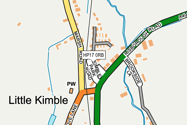
HP17 0RB lies on Kimble Park Road in Little Kimble, Aylesbury. HP17 0RB is located in the Ridgeway East electoral ward, within the unitary authority of Buckinghamshire and the English Parliamentary constituency of Buckingham. The Sub Integrated Care Board (ICB) Location is NHS Buckinghamshire, Oxfordshire and Berkshire West ICB - 14Y and the police force is Thames Valley. This postcode has been in use since December 1999.


GetTheData
Source: OS OpenMap – Local (Ordnance Survey)
Source: OS VectorMap District (Ordnance Survey)
Licence: Open Government Licence (requires attribution)
| Easting | 482334 |
| Northing | 207063 |
| Latitude | 51.756215 |
| Longitude | -0.808565 |
GetTheData
Source: Open Postcode Geo
Licence: Open Government Licence
| Street | Kimble Park Road |
| Locality | Little Kimble |
| Town/City | Aylesbury |
| Country | England |
| Postcode District | HP17 |
➜ See where HP17 is on a map ➜ Where is Little Kimble? | |
GetTheData
Source: Land Registry Price Paid Data
Licence: Open Government Licence
Elevation or altitude of HP17 0RB as distance above sea level:
| Metres | Feet | |
|---|---|---|
| Elevation | 100m | 328ft |
Elevation is measured from the approximate centre of the postcode, to the nearest point on an OS contour line from OS Terrain 50, which has contour spacing of ten vertical metres.
➜ How high above sea level am I? Find the elevation of your current position using your device's GPS.
GetTheData
Source: Open Postcode Elevation
Licence: Open Government Licence
| Ward | Ridgeway East |
| Constituency | Buckingham |
GetTheData
Source: ONS Postcode Database
Licence: Open Government Licence
SYCAMORE HOUSE, KIMBLE PARK ROAD, LITTLE KIMBLE, AYLESBURY, HP17 0RB 2004 31 MAR £199,750 |
SYCAMORE HOUSE, KIMBLE PARK ROAD, LITTLE KIMBLE, AYLESBURY, HP17 0RB 2001 31 JAN £158,625 |
GetTheData
Source: HM Land Registry Price Paid Data
Licence: Contains HM Land Registry data © Crown copyright and database right 2025. This data is licensed under the Open Government Licence v3.0.
| Brookside Lane (Aylesbury Road) | Little Kimble | 93m |
| Brookside Lane (Aylesbury Road) | Little Kimble | 116m |
| Grove Lane | Little Kimble | 278m |
| Grove Lane | Little Kimble | 282m |
| Railway Station (Aylesbury Road) | Little Kimble | 356m |
| Little Kimble Station | 0.4km |
| Monks Risborough Station | 2.7km |
| Stoke Mandeville Station | 3.9km |
GetTheData
Source: NaPTAN
Licence: Open Government Licence
GetTheData
Source: ONS Postcode Database
Licence: Open Government Licence


➜ Get more ratings from the Food Standards Agency
GetTheData
Source: Food Standards Agency
Licence: FSA terms & conditions
| Last Collection | |||
|---|---|---|---|
| Location | Mon-Fri | Sat | Distance |
| Clanking | 16:15 | 10:30 | 64m |
| Little Kimble | 16:30 | 08:15 | 706m |
| Bridge Street Po | 16:30 | 10:30 | 858m |
GetTheData
Source: Dracos
Licence: Creative Commons Attribution-ShareAlike
The below table lists the International Territorial Level (ITL) codes (formerly Nomenclature of Territorial Units for Statistics (NUTS) codes) and Local Administrative Units (LAU) codes for HP17 0RB:
| ITL 1 Code | Name |
|---|---|
| TLJ | South East (England) |
| ITL 2 Code | Name |
| TLJ1 | Berkshire, Buckinghamshire and Oxfordshire |
| ITL 3 Code | Name |
| TLJ13 | Buckinghamshire |
| LAU 1 Code | Name |
| E06000060 | Buckinghamshire |
GetTheData
Source: ONS Postcode Directory
Licence: Open Government Licence
The below table lists the Census Output Area (OA), Lower Layer Super Output Area (LSOA), and Middle Layer Super Output Area (MSOA) for HP17 0RB:
| Code | Name | |
|---|---|---|
| OA | E00090235 | |
| LSOA | E01017886 | Wycombe 002B |
| MSOA | E02003697 | Wycombe 002 |
GetTheData
Source: ONS Postcode Directory
Licence: Open Government Licence
| HP17 0RA | Old Chapel Close | 36m |
| HP22 5XR | Providence Cottages | 76m |
| HP17 0UF | Risborough Road | 128m |
| HP22 5XS | Marsh Road | 296m |
| HP17 0XN | Station Road | 389m |
| HP17 9TR | Grove Lane | 574m |
| HP17 0XL | Ellesborough Road | 643m |
| HP17 0UE | Aylesbury Road | 651m |
| HP17 0XJ | Ellesborough Road | 695m |
| HP17 0XR | Ellesborough Road | 792m |
GetTheData
Source: Open Postcode Geo; Land Registry Price Paid Data
Licence: Open Government Licence