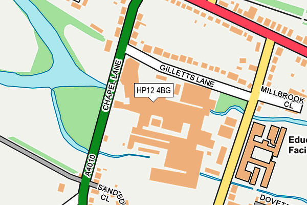
HP12 4BG is located in the West Wycombe electoral ward, within the unitary authority of Buckinghamshire and the English Parliamentary constituency of Wycombe. The Sub Integrated Care Board (ICB) Location is NHS Buckinghamshire, Oxfordshire and Berkshire West ICB - 14Y and the police force is Thames Valley. This postcode has been in use since January 1980.


GetTheData
Source: OS OpenMap – Local (Ordnance Survey)
Source: OS VectorMap District (Ordnance Survey)
Licence: Open Government Licence (requires attribution)
| Easting | 484360 |
| Northing | 193966 |
| Latitude | 51.638183 |
| Longitude | -0.782383 |
GetTheData
Source: Open Postcode Geo
Licence: Open Government Licence
| Country | England |
| Postcode District | HP12 |
➜ See where HP12 is on a map ➜ Where is High Wycombe? | |
GetTheData
Source: Land Registry Price Paid Data
Licence: Open Government Licence
Elevation or altitude of HP12 4BG as distance above sea level:
| Metres | Feet | |
|---|---|---|
| Elevation | 80m | 262ft |
Elevation is measured from the approximate centre of the postcode, to the nearest point on an OS contour line from OS Terrain 50, which has contour spacing of ten vertical metres.
➜ How high above sea level am I? Find the elevation of your current position using your device's GPS.
GetTheData
Source: Open Postcode Elevation
Licence: Open Government Licence
| Ward | West Wycombe |
| Constituency | Wycombe |
GetTheData
Source: ONS Postcode Database
Licence: Open Government Licence
| Gilletts Lane (Chapel Lane) | Sands | 85m |
| Gilletts Lane (Chapel Lane) | Sands | 130m |
| Millbrook School (Mill End Road) | High Wycombe | 187m |
| Downley Turn (West Wycombe Road) | High Wycombe | 225m |
| Mill End Road (West Wycombe Road) | High Wycombe | 283m |
| High Wycombe Station | 2.7km |
| Saunderton Station | 5.1km |
GetTheData
Source: NaPTAN
Licence: Open Government Licence
GetTheData
Source: ONS Postcode Database
Licence: Open Government Licence

➜ Get more ratings from the Food Standards Agency
GetTheData
Source: Food Standards Agency
Licence: FSA terms & conditions
| Last Collection | |||
|---|---|---|---|
| Location | Mon-Fri | Sat | Distance |
| Eaton Avenue | 18:15 | 12:00 | 291m |
| Heathfield Road | 16:45 | 12:00 | 432m |
| Southfield Road | 16:45 | 12:00 | 545m |
GetTheData
Source: Dracos
Licence: Creative Commons Attribution-ShareAlike
The below table lists the International Territorial Level (ITL) codes (formerly Nomenclature of Territorial Units for Statistics (NUTS) codes) and Local Administrative Units (LAU) codes for HP12 4BG:
| ITL 1 Code | Name |
|---|---|
| TLJ | South East (England) |
| ITL 2 Code | Name |
| TLJ1 | Berkshire, Buckinghamshire and Oxfordshire |
| ITL 3 Code | Name |
| TLJ13 | Buckinghamshire |
| LAU 1 Code | Name |
| E06000060 | Buckinghamshire |
GetTheData
Source: ONS Postcode Directory
Licence: Open Government Licence
The below table lists the Census Output Area (OA), Lower Layer Super Output Area (LSOA), and Middle Layer Super Output Area (MSOA) for HP12 4BG:
| Code | Name | |
|---|---|---|
| OA | E00090358 | |
| LSOA | E01017912 | Wycombe 012B |
| MSOA | E02003707 | Wycombe 012 |
GetTheData
Source: ONS Postcode Directory
Licence: Open Government Licence
| HP12 4BB | Gilletts Lane | 102m |
| HP12 4BD | Chapel Lane | 151m |
| HP12 4BJ | Chapel Lane | 171m |
| HP12 4AA | West Wycombe Road | 195m |
| HP12 4AX | Mill End Road | 206m |
| HP12 4FA | Sandsdown Close | 237m |
| HP12 4AB | West Wycombe Road | 245m |
| HP12 4BU | Penmoor Close | 309m |
| HP12 4JY | Mill End Road | 314m |
| HP13 5JQ | Plomer Hill | 322m |
GetTheData
Source: Open Postcode Geo; Land Registry Price Paid Data
Licence: Open Government Licence