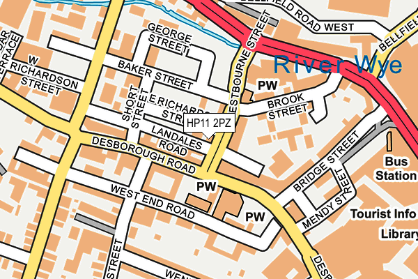
HP11 2PZ lies on Westbourne Street in High Wycombe. HP11 2PZ is located in the Abbey electoral ward, within the unitary authority of Buckinghamshire and the English Parliamentary constituency of Wycombe. The Sub Integrated Care Board (ICB) Location is NHS Buckinghamshire, Oxfordshire and Berkshire West ICB - 14Y and the police force is Thames Valley. This postcode has been in use since January 1980.


GetTheData
Source: OS OpenMap – Local (Ordnance Survey)
Source: OS VectorMap District (Ordnance Survey)
Licence: Open Government Licence (requires attribution)
| Easting | 485945 |
| Northing | 193265 |
| Latitude | 51.631642 |
| Longitude | -0.759657 |
GetTheData
Source: Open Postcode Geo
Licence: Open Government Licence
| Street | Westbourne Street |
| Town/City | High Wycombe |
| Country | England |
| Postcode District | HP11 |
➜ See where HP11 is on a map ➜ Where is High Wycombe? | |
GetTheData
Source: Land Registry Price Paid Data
Licence: Open Government Licence
Elevation or altitude of HP11 2PZ as distance above sea level:
| Metres | Feet | |
|---|---|---|
| Elevation | 70m | 230ft |
Elevation is measured from the approximate centre of the postcode, to the nearest point on an OS contour line from OS Terrain 50, which has contour spacing of ten vertical metres.
➜ How high above sea level am I? Find the elevation of your current position using your device's GPS.
GetTheData
Source: Open Postcode Elevation
Licence: Open Government Licence
| Ward | Abbey |
| Constituency | Wycombe |
GetTheData
Source: ONS Postcode Database
Licence: Open Government Licence
| St John's Church (Desborough Road) | High Wycombe | 59m |
| St John's Church (Desborough Road) | High Wycombe | 69m |
| Bridge Street | High Wycombe | 151m |
| Brook Street (West Wycombe Road) | High Wycombe | 169m |
| Riverside (West Wycombe Road) | High Wycombe | 208m |
| High Wycombe Station | 1km |
| Saunderton Station | 6.7km |
GetTheData
Source: NaPTAN
Licence: Open Government Licence
GetTheData
Source: ONS Postcode Database
Licence: Open Government Licence


➜ Get more ratings from the Food Standards Agency
GetTheData
Source: Food Standards Agency
Licence: FSA terms & conditions
| Last Collection | |||
|---|---|---|---|
| Location | Mon-Fri | Sat | Distance |
| Desborough Road P.o. | 18:30 | 12:00 | 97m |
| Desborough Avenue | 18:30 | 12:00 | 201m |
| Suffield Road | 17:00 | 12:00 | 399m |
GetTheData
Source: Dracos
Licence: Creative Commons Attribution-ShareAlike
The below table lists the International Territorial Level (ITL) codes (formerly Nomenclature of Territorial Units for Statistics (NUTS) codes) and Local Administrative Units (LAU) codes for HP11 2PZ:
| ITL 1 Code | Name |
|---|---|
| TLJ | South East (England) |
| ITL 2 Code | Name |
| TLJ1 | Berkshire, Buckinghamshire and Oxfordshire |
| ITL 3 Code | Name |
| TLJ13 | Buckinghamshire |
| LAU 1 Code | Name |
| E06000060 | Buckinghamshire |
GetTheData
Source: ONS Postcode Directory
Licence: Open Government Licence
The below table lists the Census Output Area (OA), Lower Layer Super Output Area (LSOA), and Middle Layer Super Output Area (MSOA) for HP11 2PZ:
| Code | Name | |
|---|---|---|
| OA | E00172600 | |
| LSOA | E01017837 | Wycombe 015B |
| MSOA | E02003710 | Wycombe 015 |
GetTheData
Source: ONS Postcode Directory
Licence: Open Government Licence
| HP11 2QA | Desborough Road | 56m |
| HP11 2RQ | Desborough Road | 71m |
| HP11 2PU | Desborough Road | 73m |
| HP11 2UE | West End Road | 106m |
| HP11 2EQ | Brook Street | 110m |
| HP11 2QB | West End Road | 119m |
| HP11 2QH | Short Street | 123m |
| HP11 2PQ | West End Road | 129m |
| HP11 2PW | West End Road | 133m |
| HP11 2QE | West End Street | 153m |
GetTheData
Source: Open Postcode Geo; Land Registry Price Paid Data
Licence: Open Government Licence