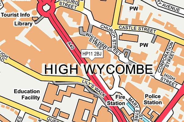
HP11 2BJ is located in the Abbey electoral ward, within the unitary authority of Buckinghamshire and the English Parliamentary constituency of Wycombe. The Sub Integrated Care Board (ICB) Location is NHS Buckinghamshire, Oxfordshire and Berkshire West ICB - 14Y and the police force is Thames Valley. This postcode has been in use since March 2008.


GetTheData
Source: OS OpenMap – Local (Ordnance Survey)
Source: OS VectorMap District (Ordnance Survey)
Licence: Open Government Licence (requires attribution)
| Easting | 486445 |
| Northing | 193007 |
| Latitude | 51.629249 |
| Longitude | -0.752479 |
GetTheData
Source: Open Postcode Geo
Licence: Open Government Licence
| Country | England |
| Postcode District | HP11 |
➜ See where HP11 is on a map ➜ Where is High Wycombe? | |
GetTheData
Source: Land Registry Price Paid Data
Licence: Open Government Licence
Elevation or altitude of HP11 2BJ as distance above sea level:
| Metres | Feet | |
|---|---|---|
| Elevation | 70m | 230ft |
Elevation is measured from the approximate centre of the postcode, to the nearest point on an OS contour line from OS Terrain 50, which has contour spacing of ten vertical metres.
➜ How high above sea level am I? Find the elevation of your current position using your device's GPS.
GetTheData
Source: Open Postcode Elevation
Licence: Open Government Licence
| Ward | Abbey |
| Constituency | Wycombe |
GetTheData
Source: ONS Postcode Database
Licence: Open Government Licence
| Oxford Street | High Wycombe | 177m |
| University Main Campus (Abbey Way) | High Wycombe | 190m |
| Oxford Street | High Wycombe | 198m |
| Wycombe General Hospital (Queen Alexandra Road) | High Wycombe | 225m |
| High Street | High Wycombe | 233m |
| High Wycombe Station | 0.5km |
GetTheData
Source: NaPTAN
Licence: Open Government Licence
GetTheData
Source: ONS Postcode Database
Licence: Open Government Licence


➜ Get more ratings from the Food Standards Agency
GetTheData
Source: Food Standards Agency
Licence: FSA terms & conditions
| Last Collection | |||
|---|---|---|---|
| Location | Mon-Fri | Sat | Distance |
| Guildhall | 18:30 | 12:00 | 83m |
| White Hart Street | 17:00 | 94m | |
| Chilterns Bo | 17:30 | 12:00 | 157m |
GetTheData
Source: Dracos
Licence: Creative Commons Attribution-ShareAlike
| Risk of HP11 2BJ flooding from rivers and sea | Low |
| ➜ HP11 2BJ flood map | |
GetTheData
Source: Open Flood Risk by Postcode
Licence: Open Government Licence
The below table lists the International Territorial Level (ITL) codes (formerly Nomenclature of Territorial Units for Statistics (NUTS) codes) and Local Administrative Units (LAU) codes for HP11 2BJ:
| ITL 1 Code | Name |
|---|---|
| TLJ | South East (England) |
| ITL 2 Code | Name |
| TLJ1 | Berkshire, Buckinghamshire and Oxfordshire |
| ITL 3 Code | Name |
| TLJ13 | Buckinghamshire |
| LAU 1 Code | Name |
| E06000060 | Buckinghamshire |
GetTheData
Source: ONS Postcode Directory
Licence: Open Government Licence
The below table lists the Census Output Area (OA), Lower Layer Super Output Area (LSOA), and Middle Layer Super Output Area (MSOA) for HP11 2BJ:
| Code | Name | |
|---|---|---|
| OA | E00172608 | |
| LSOA | E01017839 | Wycombe 015D |
| MSOA | E02003710 | Wycombe 015 |
GetTheData
Source: ONS Postcode Directory
Licence: Open Government Licence
| HP11 2HL | White Hart Street | 60m |
| HP11 2DE | Church Street | 101m |
| HP11 2DF | Queens Square | 109m |
| HP11 2HF | Crown Lane | 112m |
| HP11 2DL | Bull Lane | 122m |
| HP11 2BN | Church Square | 139m |
| HP11 2BP | Queens Square | 144m |
| HP11 2AZ | High Street | 157m |
| HP11 2DG | Oxford Street | 159m |
| HP13 6RZ | Castle Street | 169m |
GetTheData
Source: Open Postcode Geo; Land Registry Price Paid Data
Licence: Open Government Licence