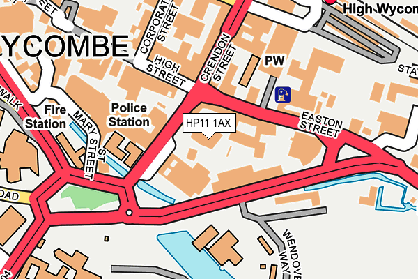
HP11 1AX is located in the Abbey electoral ward, within the unitary authority of Buckinghamshire and the English Parliamentary constituency of Wycombe. The Sub Integrated Care Board (ICB) Location is NHS Buckinghamshire, Oxfordshire and Berkshire West ICB - 14Y and the police force is Thames Valley. This postcode has been in use since May 2017.


GetTheData
Source: OS OpenMap – Local (Ordnance Survey)
Source: OS VectorMap District (Ordnance Survey)
Licence: Open Government Licence (requires attribution)
| Easting | 486762 |
| Northing | 191623 |
| Latitude | 51.616760 |
| Longitude | -0.748243 |
GetTheData
Source: Open Postcode Geo
Licence: Open Government Licence
| Country | England |
| Postcode District | HP11 |
➜ See where HP11 is on a map ➜ Where is High Wycombe? | |
GetTheData
Source: Land Registry Price Paid Data
Licence: Open Government Licence
| Ward | Abbey |
| Constituency | Wycombe |
GetTheData
Source: ONS Postcode Database
Licence: Open Government Licence
| Daws Lea (Daws Hill Lane) | High Wycombe | 176m |
| Daws Lea (Daws Hill Lane) | High Wycombe | 180m |
| St Michael's School (Daws Hill Lane) | High Wycombe | 383m |
| St Michael's School (Daws Hill Lane) | High Wycombe | 386m |
| St Michael's Campus (Daws Hill Lane) | High Wycombe | 390m |
| High Wycombe Station | 1.4km |
| Bourne End Station | 5.1km |
GetTheData
Source: NaPTAN
Licence: Open Government Licence
| Percentage of properties with Next Generation Access | 100.0% |
| Percentage of properties with Superfast Broadband | 100.0% |
| Percentage of properties with Ultrafast Broadband | 100.0% |
| Percentage of properties with Full Fibre Broadband | 100.0% |
Superfast Broadband is between 30Mbps and 300Mbps
Ultrafast Broadband is > 300Mbps
| Percentage of properties unable to receive 2Mbps | 0.0% |
| Percentage of properties unable to receive 5Mbps | 0.0% |
| Percentage of properties unable to receive 10Mbps | 0.0% |
| Percentage of properties unable to receive 30Mbps | 0.0% |
GetTheData
Source: Ofcom
Licence: Ofcom Terms of Use (requires attribution)
GetTheData
Source: ONS Postcode Database
Licence: Open Government Licence


➜ Get more ratings from the Food Standards Agency
GetTheData
Source: Food Standards Agency
Licence: FSA terms & conditions
| Last Collection | |||
|---|---|---|---|
| Location | Mon-Fri | Sat | Distance |
| Daws Hill Lane | 16:30 | 12:00 | 97m |
| School Close | 16:30 | 12:00 | 890m |
| Tennyson Road | 18:00 | 12:00 | 908m |
GetTheData
Source: Dracos
Licence: Creative Commons Attribution-ShareAlike
The below table lists the International Territorial Level (ITL) codes (formerly Nomenclature of Territorial Units for Statistics (NUTS) codes) and Local Administrative Units (LAU) codes for HP11 1AX:
| ITL 1 Code | Name |
|---|---|
| TLJ | South East (England) |
| ITL 2 Code | Name |
| TLJ1 | Berkshire, Buckinghamshire and Oxfordshire |
| ITL 3 Code | Name |
| TLJ13 | Buckinghamshire |
| LAU 1 Code | Name |
| E06000060 | Buckinghamshire |
GetTheData
Source: ONS Postcode Directory
Licence: Open Government Licence
The below table lists the Census Output Area (OA), Lower Layer Super Output Area (LSOA), and Middle Layer Super Output Area (MSOA) for HP11 1AX:
| Code | Name | |
|---|---|---|
| OA | E00089995 | |
| LSOA | E01017841 | Wycombe 015F |
| MSOA | E02003710 | Wycombe 015 |
GetTheData
Source: ONS Postcode Directory
Licence: Open Government Licence
| HP11 1BQ | Eisenhower Lower Close | 69m |
| HP11 1PU | Daws Hill Lane | 105m |
| HP11 1PX | Knights Templar Way | 171m |
| HP11 1QJ | Kew Grove | 187m |
| HP11 1QT | Sandford Gardens | 193m |
| HP11 1QR | Westminster Close | 205m |
| HP11 1QW | Kew Place | 208m |
| HP11 1QH | Bellwood Rise | 224m |
| HP11 1QF | Daws Lea | 237m |
| HP11 1PY | Knights Templar Way | 269m |
GetTheData
Source: Open Postcode Geo; Land Registry Price Paid Data
Licence: Open Government Licence