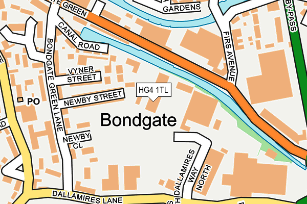
HG4 1TL is located in the Ripon Minster & Moorside electoral ward, within the unitary authority of North Yorkshire and the English Parliamentary constituency of Skipton and Ripon. The Sub Integrated Care Board (ICB) Location is NHS Humber and North Yorkshire ICB - 42D and the police force is North Yorkshire. This postcode has been in use since January 1980.


GetTheData
Source: OS OpenMap – Local (Ordnance Survey)
Source: OS VectorMap District (Ordnance Survey)
Licence: Open Government Licence (requires attribution)
| Easting | 431701 |
| Northing | 470709 |
| Latitude | 54.131259 |
| Longitude | -1.516361 |
GetTheData
Source: Open Postcode Geo
Licence: Open Government Licence
| Country | England |
| Postcode District | HG4 |
➜ See where HG4 is on a map ➜ Where is Ripon? | |
GetTheData
Source: Land Registry Price Paid Data
Licence: Open Government Licence
Elevation or altitude of HG4 1TL as distance above sea level:
| Metres | Feet | |
|---|---|---|
| Elevation | 20m | 66ft |
Elevation is measured from the approximate centre of the postcode, to the nearest point on an OS contour line from OS Terrain 50, which has contour spacing of ten vertical metres.
➜ How high above sea level am I? Find the elevation of your current position using your device's GPS.
GetTheData
Source: Open Postcode Elevation
Licence: Open Government Licence
| Ward | Ripon Minster & Moorside |
| Constituency | Skipton And Ripon |
GetTheData
Source: ONS Postcode Database
Licence: Open Government Licence
| Firs Avenue (Boroughbridge Road) | Ripon | 157m |
| Firs Avenue (Boroughbridge Road) | Ripon | 175m |
| Bowling Club (Bondgate Green) | Ripon | 250m |
| Bowling Club (Bondgate Green) | Ripon | 255m |
| Bondgate | Ripon | 284m |
GetTheData
Source: NaPTAN
Licence: Open Government Licence
GetTheData
Source: ONS Postcode Database
Licence: Open Government Licence


➜ Get more ratings from the Food Standards Agency
GetTheData
Source: Food Standards Agency
Licence: FSA terms & conditions
| Last Collection | |||
|---|---|---|---|
| Location | Mon-Fri | Sat | Distance |
| Bondgate P.o. | 18:15 | 12:00 | 262m |
| Ure Bank Terrace/Top | 17:30 | 12:30 | 1,528m |
| Lark Lane P.o. | 17:30 | 12:15 | 1,920m |
GetTheData
Source: Dracos
Licence: Creative Commons Attribution-ShareAlike
| Risk of HG4 1TL flooding from rivers and sea | Low |
| ➜ HG4 1TL flood map | |
GetTheData
Source: Open Flood Risk by Postcode
Licence: Open Government Licence
The below table lists the International Territorial Level (ITL) codes (formerly Nomenclature of Territorial Units for Statistics (NUTS) codes) and Local Administrative Units (LAU) codes for HG4 1TL:
| ITL 1 Code | Name |
|---|---|
| TLE | Yorkshire and The Humber |
| ITL 2 Code | Name |
| TLE2 | North Yorkshire |
| ITL 3 Code | Name |
| TLE22 | North Yorkshire CC |
| LAU 1 Code | Name |
| E07000165 | Harrogate |
GetTheData
Source: ONS Postcode Directory
Licence: Open Government Licence
The below table lists the Census Output Area (OA), Lower Layer Super Output Area (LSOA), and Middle Layer Super Output Area (MSOA) for HG4 1TL:
| Code | Name | |
|---|---|---|
| OA | E00141106 | |
| LSOA | E01027707 | Harrogate 004C |
| MSOA | E02005764 | Harrogate 004 |
GetTheData
Source: ONS Postcode Directory
Licence: Open Government Licence
| HG4 1QH | Newby Street | 99m |
| HG4 1QJ | Vyner Street | 140m |
| HG4 1SJ | Newby Close | 145m |
| HG4 1QN | Canal Road | 165m |
| HG4 1QQ | Bondgate Green Lane | 182m |
| HG4 1AQ | Canal Wharf | 186m |
| HG4 1NJ | Firs Avenue | 201m |
| HG4 1NH | Alma Gardens | 239m |
| HG4 1UE | Boroughbridge Road | 250m |
| HG4 1QW | Bondgate Green | 252m |
GetTheData
Source: Open Postcode Geo; Land Registry Price Paid Data
Licence: Open Government Licence