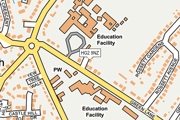
HG2 9NZ is located in the Harlow & St. Georges electoral ward, within the unitary authority of North Yorkshire and the English Parliamentary constituency of Harrogate and Knaresborough. The Sub Integrated Care Board (ICB) Location is NHS Humber and North Yorkshire ICB - 42D and the police force is North Yorkshire. This postcode has been in use since April 2017.


GetTheData
Source: OS OpenMap – Local (Ordnance Survey)
Source: OS VectorMap District (Ordnance Survey)
Licence: Open Government Licence (requires attribution)
| Easting | 429463 |
| Northing | 453273 |
| Latitude | 53.974704 |
| Longitude | -1.552301 |
GetTheData
Source: Open Postcode Geo
Licence: Open Government Licence
| Country | England |
| Postcode District | HG2 |
➜ See where HG2 is on a map ➜ Where is Harrogate? | |
GetTheData
Source: Land Registry Price Paid Data
Licence: Open Government Licence
| Ward | Harlow & St. Georges |
| Constituency | Harrogate And Knaresborough |
GetTheData
Source: ONS Postcode Database
Licence: Open Government Licence
| Rosett High Sch Grounds (Yew Tree Lane) | Pannal Ash | 81m |
| Rossett School (Yew Tree Lane) | Pannal Ash | 98m |
| Yew Tree Walk (Yew Tree Lane) | Pannal Ash | 169m |
| Ashville College (Green Lane) | Pannal Ash | 175m |
| Ashville Coll (Green Lane) | Pannal Ash | 186m |
| Hornbeam Park Station | 1.8km |
| Pannal Station | 2.2km |
| Harrogate Station | 2.3km |
GetTheData
Source: NaPTAN
Licence: Open Government Licence
| Percentage of properties with Next Generation Access | 100.0% |
| Percentage of properties with Superfast Broadband | 100.0% |
| Percentage of properties with Ultrafast Broadband | 0.0% |
| Percentage of properties with Full Fibre Broadband | 0.0% |
Superfast Broadband is between 30Mbps and 300Mbps
Ultrafast Broadband is > 300Mbps
| Median download speed | 77.8Mbps |
| Average download speed | 86.2Mbps |
| Maximum download speed | 193.06Mbps |
| Median upload speed | 19.8Mbps |
| Average upload speed | 16.0Mbps |
| Maximum upload speed | 20.00Mbps |
| Percentage of properties unable to receive 2Mbps | 0.0% |
| Percentage of properties unable to receive 5Mbps | 0.0% |
| Percentage of properties unable to receive 10Mbps | 0.0% |
| Percentage of properties unable to receive 30Mbps | 0.0% |
GetTheData
Source: Ofcom
Licence: Ofcom Terms of Use (requires attribution)
GetTheData
Source: ONS Postcode Database
Licence: Open Government Licence


➜ Get more ratings from the Food Standards Agency
GetTheData
Source: Food Standards Agency
Licence: FSA terms & conditions
| Last Collection | |||
|---|---|---|---|
| Location | Mon-Fri | Sat | Distance |
| 50 Leadhall Lane | 18:00 | 11:45 | 981m |
| Swinton Court | 17:45 | 12:30 | 1,022m |
| Norfolk Road | 18:15 | 12:00 | 1,057m |
GetTheData
Source: Dracos
Licence: Creative Commons Attribution-ShareAlike
The below table lists the International Territorial Level (ITL) codes (formerly Nomenclature of Territorial Units for Statistics (NUTS) codes) and Local Administrative Units (LAU) codes for HG2 9NZ:
| ITL 1 Code | Name |
|---|---|
| TLE | Yorkshire and The Humber |
| ITL 2 Code | Name |
| TLE2 | North Yorkshire |
| ITL 3 Code | Name |
| TLE22 | North Yorkshire CC |
| LAU 1 Code | Name |
| E07000165 | Harrogate |
GetTheData
Source: ONS Postcode Directory
Licence: Open Government Licence
The below table lists the Census Output Area (OA), Lower Layer Super Output Area (LSOA), and Middle Layer Super Output Area (MSOA) for HG2 9NZ:
| Code | Name | |
|---|---|---|
| OA | E00141155 | |
| LSOA | E01027719 | Harrogate 020G |
| MSOA | E02005780 | Harrogate 020 |
GetTheData
Source: ONS Postcode Directory
Licence: Open Government Licence
| HG2 9JP | Green Lane | 25m |
| HG2 9JS | Yew Tree Lane | 196m |
| HG2 9PP | Rossett Gardens | 198m |
| HG2 9JL | Pannal Ash Road | 211m |
| HG2 9JT | Yew Tree Walk | 225m |
| HG2 9JG | Castle Hill Glade | 254m |
| HG2 9NA | Rossett Avenue | 265m |
| HG2 9LS | Whinney Lane | 288m |
| HG2 9DJ | Robinson Drive | 288m |
| HG2 9LT | Whinney Lane | 298m |
GetTheData
Source: Open Postcode Geo; Land Registry Price Paid Data
Licence: Open Government Licence