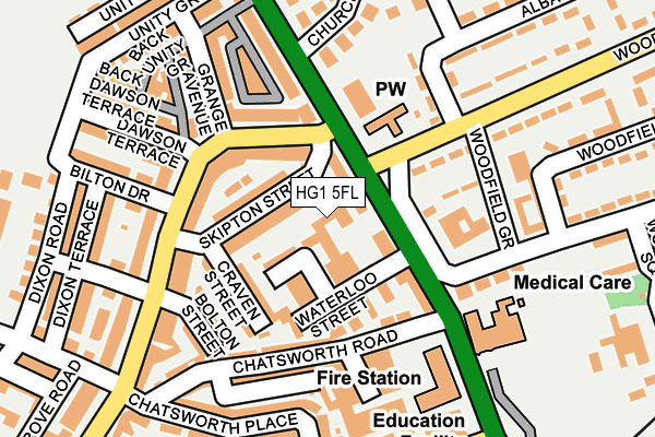
HG1 5FL is located in the Coppice Valley & Duchy electoral ward, within the unitary authority of North Yorkshire and the English Parliamentary constituency of Harrogate and Knaresborough. The Sub Integrated Care Board (ICB) Location is NHS Humber and North Yorkshire ICB - 42D and the police force is North Yorkshire. This postcode has been in use since May 2017.


GetTheData
Source: OS OpenMap – Local (Ordnance Survey)
Source: OS VectorMap District (Ordnance Survey)
Licence: Open Government Licence (requires attribution)
| Easting | 430556 |
| Northing | 456396 |
| Latitude | 54.002709 |
| Longitude | -1.535326 |
GetTheData
Source: Open Postcode Geo
Licence: Open Government Licence
| Country | England |
| Postcode District | HG1 |
➜ See where HG1 is on a map ➜ Where is Harrogate? | |
GetTheData
Source: Land Registry Price Paid Data
Licence: Open Government Licence
| Ward | Coppice Valley & Duchy |
| Constituency | Harrogate And Knaresborough |
GetTheData
Source: ONS Postcode Database
Licence: Open Government Licence
| Waterloo Street (Skipton Road) | Bilton | 92m |
| Kings Road Post Office (King's Road) | Bilton | 118m |
| Woodfield Road Top (Woodfield Road) | Bilton | 120m |
| Kings Road Post Office (King's Road) | Bilton | 126m |
| Woodfield Road Top (Woodfield Road) | Bilton | 174m |
| Harrogate Station | 1.1km |
| Starbeck Station | 2.3km |
| Hornbeam Park Station | 2.6km |
GetTheData
Source: NaPTAN
Licence: Open Government Licence
| Percentage of properties with Next Generation Access | 100.0% |
| Percentage of properties with Superfast Broadband | 100.0% |
| Percentage of properties with Ultrafast Broadband | 0.0% |
| Percentage of properties with Full Fibre Broadband | 0.0% |
Superfast Broadband is between 30Mbps and 300Mbps
Ultrafast Broadband is > 300Mbps
| Median download speed | 40.0Mbps |
| Average download speed | 34.0Mbps |
| Maximum download speed | 54.16Mbps |
| Median upload speed | 8.9Mbps |
| Average upload speed | 6.7Mbps |
| Maximum upload speed | 10.00Mbps |
| Percentage of properties unable to receive 2Mbps | 0.0% |
| Percentage of properties unable to receive 5Mbps | 0.0% |
| Percentage of properties unable to receive 10Mbps | 0.0% |
| Percentage of properties unable to receive 30Mbps | 0.0% |
GetTheData
Source: Ofcom
Licence: Ofcom Terms of Use (requires attribution)
GetTheData
Source: ONS Postcode Database
Licence: Open Government Licence


➜ Get more ratings from the Food Standards Agency
GetTheData
Source: Food Standards Agency
Licence: FSA terms & conditions
| Last Collection | |||
|---|---|---|---|
| Location | Mon-Fri | Sat | Distance |
| Kings Road P.o. | 18:30 | 11:30 | 117m |
| Electric Ave | 18:15 | 13:30 | 277m |
| Grove Park Terrace/Walk | 18:00 | 13:30 | 455m |
GetTheData
Source: Dracos
Licence: Creative Commons Attribution-ShareAlike
The below table lists the International Territorial Level (ITL) codes (formerly Nomenclature of Territorial Units for Statistics (NUTS) codes) and Local Administrative Units (LAU) codes for HG1 5FL:
| ITL 1 Code | Name |
|---|---|
| TLE | Yorkshire and The Humber |
| ITL 2 Code | Name |
| TLE2 | North Yorkshire |
| ITL 3 Code | Name |
| TLE22 | North Yorkshire CC |
| LAU 1 Code | Name |
| E07000165 | Harrogate |
GetTheData
Source: ONS Postcode Directory
Licence: Open Government Licence
The below table lists the Census Output Area (OA), Lower Layer Super Output Area (LSOA), and Middle Layer Super Output Area (MSOA) for HG1 5FL:
| Code | Name | |
|---|---|---|
| OA | E00140845 | |
| LSOA | E01027657 | Harrogate 013C |
| MSOA | E02005773 | Harrogate 013 |
GetTheData
Source: ONS Postcode Directory
Licence: Open Government Licence
| HG1 5JB | Roker Road | 47m |
| HG1 4LF | Skipton Road | 54m |
| HG1 5JF | Skipton Street | 55m |
| HG1 5JN | St Johns Terrace | 65m |
| HG1 5JD | Waterloo Street | 78m |
| HG1 5JG | Kings Road | 116m |
| HG1 5JE | Craven Street | 117m |
| HG1 5HX | Chatsworth Road | 127m |
| HG1 5JQ | Kings Road | 129m |
| HG1 5JA | Bolton Street | 142m |
GetTheData
Source: Open Postcode Geo; Land Registry Price Paid Data
Licence: Open Government Licence