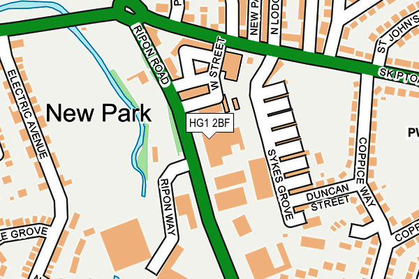
HG1 2BF is located in the Bilton Grange & New Park electoral ward, within the unitary authority of North Yorkshire and the English Parliamentary constituency of Harrogate and Knaresborough. The Sub Integrated Care Board (ICB) Location is NHS Humber and North Yorkshire ICB - 42D and the police force is North Yorkshire. This postcode has been in use since November 2004.


GetTheData
Source: OS OpenMap – Local (Ordnance Survey)
Source: OS VectorMap District (Ordnance Survey)
Licence: Open Government Licence (requires attribution)
| Easting | 429630 |
| Northing | 456728 |
| Latitude | 54.005731 |
| Longitude | -1.549415 |
GetTheData
Source: Open Postcode Geo
Licence: Open Government Licence
| Country | England |
| Postcode District | HG1 |
➜ See where HG1 is on a map ➜ Where is Harrogate? | |
GetTheData
Source: Land Registry Price Paid Data
Licence: Open Government Licence
Elevation or altitude of HG1 2BF as distance above sea level:
| Metres | Feet | |
|---|---|---|
| Elevation | 80m | 262ft |
Elevation is measured from the approximate centre of the postcode, to the nearest point on an OS contour line from OS Terrain 50, which has contour spacing of ten vertical metres.
➜ How high above sea level am I? Find the elevation of your current position using your device's GPS.
GetTheData
Source: Open Postcode Elevation
Licence: Open Government Licence
| Ward | Bilton Grange & New Park |
| Constituency | Harrogate And Knaresborough |
GetTheData
Source: ONS Postcode Database
Licence: Open Government Licence
| Little Wonder Ph (Ripon Road) | New Park | 68m |
| Little Wonder Ph (Ripon Road) | New Park | 72m |
| School (Skipton Road) | New Park | 155m |
| School (Skipton Road) | New Park | 167m |
| Hydro (Ripon Road) | New Park | 197m |
| Harrogate Station | 1.6km |
| Hornbeam Park Station | 3.2km |
| Starbeck Station | 3.3km |
GetTheData
Source: NaPTAN
Licence: Open Government Licence
GetTheData
Source: ONS Postcode Database
Licence: Open Government Licence


➜ Get more ratings from the Food Standards Agency
GetTheData
Source: Food Standards Agency
Licence: FSA terms & conditions
| Last Collection | |||
|---|---|---|---|
| Location | Mon-Fri | Sat | Distance |
| By Kwik Fit York Place | 18:30 | 13:15 | 767m |
| Kings Road P.o. | 18:30 | 11:30 | 868m |
| Electric Ave | 18:15 | 13:30 | 880m |
GetTheData
Source: Dracos
Licence: Creative Commons Attribution-ShareAlike
The below table lists the International Territorial Level (ITL) codes (formerly Nomenclature of Territorial Units for Statistics (NUTS) codes) and Local Administrative Units (LAU) codes for HG1 2BF:
| ITL 1 Code | Name |
|---|---|
| TLE | Yorkshire and The Humber |
| ITL 2 Code | Name |
| TLE2 | North Yorkshire |
| ITL 3 Code | Name |
| TLE22 | North Yorkshire CC |
| LAU 1 Code | Name |
| E07000165 | Harrogate |
GetTheData
Source: ONS Postcode Directory
Licence: Open Government Licence
The below table lists the Census Output Area (OA), Lower Layer Super Output Area (LSOA), and Middle Layer Super Output Area (MSOA) for HG1 2BF:
| Code | Name | |
|---|---|---|
| OA | E00141035 | |
| LSOA | E01027690 | Harrogate 010D |
| MSOA | E02005770 | Harrogate 010 |
GetTheData
Source: ONS Postcode Directory
Licence: Open Government Licence
| HG1 2BZ | Omega Street | 75m |
| HG1 2BY | Ripon Road | 103m |
| HG1 2DE | Baldwin Street | 106m |
| HG1 2DB | Sykes Grove | 109m |
| HG1 2DD | Archie Street | 110m |
| HG1 3HF | Skipton Road | 131m |
| HG1 2DF | Christina Street | 135m |
| HG1 3HE | Skipton Road | 156m |
| HG1 3HS | West View | 174m |
| HG1 2DG | Duncan Street | 177m |
GetTheData
Source: Open Postcode Geo; Land Registry Price Paid Data
Licence: Open Government Licence