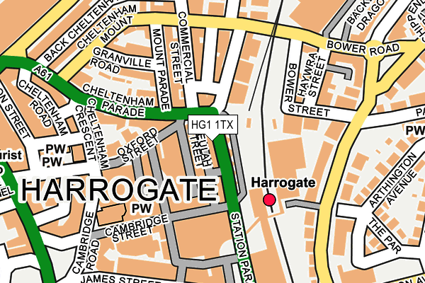
HG1 1TX lies on Station Parade in Harrogate. HG1 1TX is located in the Valley Gardens & Central Harrogate electoral ward, within the unitary authority of North Yorkshire and the English Parliamentary constituency of Harrogate and Knaresborough. The Sub Integrated Care Board (ICB) Location is NHS Humber and North Yorkshire ICB - 42D and the police force is North Yorkshire. This postcode has been in use since January 1980.


GetTheData
Source: OS OpenMap – Local (Ordnance Survey)
Source: OS VectorMap District (Ordnance Survey)
Licence: Open Government Licence (requires attribution)
| Easting | 430341 |
| Northing | 455448 |
| Latitude | 53.994201 |
| Longitude | -1.538700 |
GetTheData
Source: Open Postcode Geo
Licence: Open Government Licence
| Street | Station Parade |
| Town/City | Harrogate |
| Country | England |
| Postcode District | HG1 |
➜ See where HG1 is on a map ➜ Where is Harrogate? | |
GetTheData
Source: Land Registry Price Paid Data
Licence: Open Government Licence
Elevation or altitude of HG1 1TX as distance above sea level:
| Metres | Feet | |
|---|---|---|
| Elevation | 120m | 394ft |
Elevation is measured from the approximate centre of the postcode, to the nearest point on an OS contour line from OS Terrain 50, which has contour spacing of ten vertical metres.
➜ How high above sea level am I? Find the elevation of your current position using your device's GPS.
GetTheData
Source: Open Postcode Elevation
Licence: Open Government Licence
| Ward | Valley Gardens & Central Harrogate |
| Constituency | Harrogate And Knaresborough |
GetTheData
Source: ONS Postcode Database
Licence: Open Government Licence
| Hgte Bus Stn Stand 13 (Station Parade) | Harrogate | 27m |
| Asda (Bower Road) | Harrogate | 192m |
| Cheltenham Crescent | West Park | 280m |
| War Memorial (James Street) | West Park | 312m |
| The Odeon (Station Avenue) | Harrogate | 322m |
| Harrogate Station | 0.1km |
| Hornbeam Park Station | 1.8km |
| Starbeck Station | 2.5km |
GetTheData
Source: NaPTAN
Licence: Open Government Licence
GetTheData
Source: ONS Postcode Database
Licence: Open Government Licence


➜ Get more ratings from the Food Standards Agency
GetTheData
Source: Food Standards Agency
Licence: FSA terms & conditions
| Last Collection | |||
|---|---|---|---|
| Location | Mon-Fri | Sat | Distance |
| Railway Station (Hg) | 18:30 | 13:15 | 153m |
| 22 Mount Parade | 18:30 | 13:30 | 166m |
| Harrogate P.o. | 18:30 | 12:45 | 181m |
GetTheData
Source: Dracos
Licence: Creative Commons Attribution-ShareAlike
The below table lists the International Territorial Level (ITL) codes (formerly Nomenclature of Territorial Units for Statistics (NUTS) codes) and Local Administrative Units (LAU) codes for HG1 1TX:
| ITL 1 Code | Name |
|---|---|
| TLE | Yorkshire and The Humber |
| ITL 2 Code | Name |
| TLE2 | North Yorkshire |
| ITL 3 Code | Name |
| TLE22 | North Yorkshire CC |
| LAU 1 Code | Name |
| E07000165 | Harrogate |
GetTheData
Source: ONS Postcode Directory
Licence: Open Government Licence
The below table lists the Census Output Area (OA), Lower Layer Super Output Area (LSOA), and Middle Layer Super Output Area (MSOA) for HG1 1TX:
| Code | Name | |
|---|---|---|
| OA | E00140975 | |
| LSOA | E01027678 | Harrogate 015E |
| MSOA | E02005775 | Harrogate 015 |
GetTheData
Source: ONS Postcode Directory
Licence: Open Government Licence
| HG1 1QH | Beulah Street | 26m |
| HG1 1QQ | Beulah Street | 58m |
| HG1 1DA | Cheltenham Parade | 69m |
| HG1 1TU | Station Parade | 82m |
| HG1 1UF | Station Parade | 105m |
| HG1 1UE | Station Parade | 106m |
| HG1 1TY | Commercial Street | 110m |
| HG1 1RX | Cambridge Street | 114m |
| HG1 5BQ | Bower Street | 122m |
| HG1 1UB | Commercial Street | 127m |
GetTheData
Source: Open Postcode Geo; Land Registry Price Paid Data
Licence: Open Government Licence