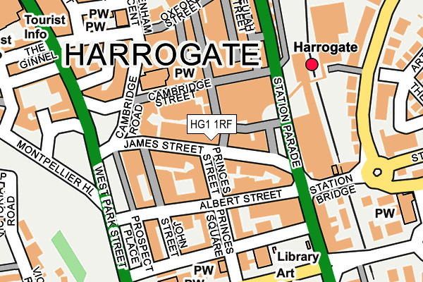
HG1 1RF lies on James Street in Harrogate. HG1 1RF is located in the Valley Gardens & Central Harrogate electoral ward, within the unitary authority of North Yorkshire and the English Parliamentary constituency of Harrogate and Knaresborough. The Sub Integrated Care Board (ICB) Location is NHS Humber and North Yorkshire ICB - 42D and the police force is North Yorkshire. This postcode has been in use since January 1980.


GetTheData
Source: OS OpenMap – Local (Ordnance Survey)
Source: OS VectorMap District (Ordnance Survey)
Licence: Open Government Licence (requires attribution)
| Easting | 430266 |
| Northing | 455259 |
| Latitude | 53.992507 |
| Longitude | -1.539863 |
GetTheData
Source: Open Postcode Geo
Licence: Open Government Licence
| Street | James Street |
| Town/City | Harrogate |
| Country | England |
| Postcode District | HG1 |
➜ See where HG1 is on a map ➜ Where is Harrogate? | |
GetTheData
Source: Land Registry Price Paid Data
Licence: Open Government Licence
Elevation or altitude of HG1 1RF as distance above sea level:
| Metres | Feet | |
|---|---|---|
| Elevation | 120m | 394ft |
Elevation is measured from the approximate centre of the postcode, to the nearest point on an OS contour line from OS Terrain 50, which has contour spacing of ten vertical metres.
➜ How high above sea level am I? Find the elevation of your current position using your device's GPS.
GetTheData
Source: Open Postcode Elevation
Licence: Open Government Licence
| Ward | Valley Gardens & Central Harrogate |
| Constituency | Harrogate And Knaresborough |
GetTheData
Source: ONS Postcode Database
Licence: Open Government Licence
| War Memorial (James Street) | West Park | 156m |
| War Memorial (James Street) | West Park | 160m |
| Montpellier Hill (West Park Street) | West Park | 175m |
| County Court (Victoria Avenue) | West Park | 229m |
| Hgte Bus Stn Stand 13 (Station Parade) | Harrogate | 229m |
| Harrogate Station | 0.2km |
| Hornbeam Park Station | 1.6km |
| Starbeck Station | 2.6km |
GetTheData
Source: NaPTAN
Licence: Open Government Licence
GetTheData
Source: ONS Postcode Database
Licence: Open Government Licence


➜ Get more ratings from the Food Standards Agency
GetTheData
Source: Food Standards Agency
Licence: FSA terms & conditions
| Last Collection | |||
|---|---|---|---|
| Location | Mon-Fri | Sat | Distance |
| James Street | 18:30 | 13:15 | 21m |
| Harrogate P.o. | 18:30 | 12:45 | 162m |
| Railway Station (Hg) | 18:30 | 13:15 | 173m |
GetTheData
Source: Dracos
Licence: Creative Commons Attribution-ShareAlike
The below table lists the International Territorial Level (ITL) codes (formerly Nomenclature of Territorial Units for Statistics (NUTS) codes) and Local Administrative Units (LAU) codes for HG1 1RF:
| ITL 1 Code | Name |
|---|---|
| TLE | Yorkshire and The Humber |
| ITL 2 Code | Name |
| TLE2 | North Yorkshire |
| ITL 3 Code | Name |
| TLE22 | North Yorkshire CC |
| LAU 1 Code | Name |
| E07000165 | Harrogate |
GetTheData
Source: ONS Postcode Directory
Licence: Open Government Licence
The below table lists the Census Output Area (OA), Lower Layer Super Output Area (LSOA), and Middle Layer Super Output Area (MSOA) for HG1 1RF:
| Code | Name | |
|---|---|---|
| OA | E00140959 | |
| LSOA | E01027679 | Harrogate 019B |
| MSOA | E02005779 | Harrogate 019 |
GetTheData
Source: ONS Postcode Directory
Licence: Open Government Licence
| HG1 1QU | James Street | 36m |
| HG1 1QY | James Street | 56m |
| HG1 1QS | James Street | 76m |
| HG1 1TD | Station Square | 82m |
| HG1 1RH | Prospect Crescent | 90m |
| HG1 1RX | Cambridge Street | 95m |
| HG1 1JG | Albert Street | 103m |
| HG1 1JZ | John Street | 104m |
| HG1 1JX | Albert Street | 108m |
| HG1 1LA | Prospect Place | 109m |
GetTheData
Source: Open Postcode Geo; Land Registry Price Paid Data
Licence: Open Government Licence