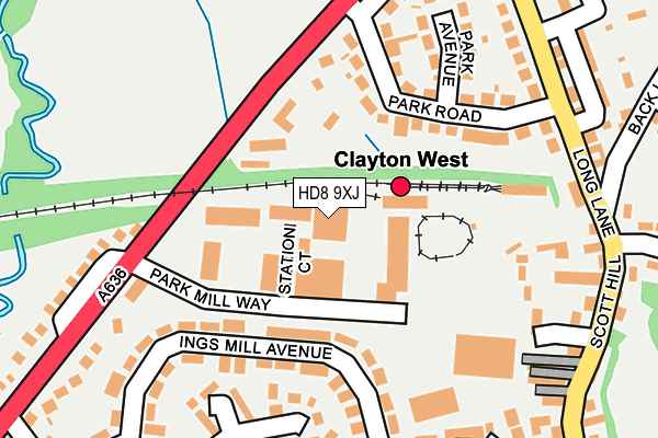
HD8 9XJ lies on Park Mill Way in Clayton West, Huddersfield. HD8 9XJ is located in the Denby Dale electoral ward, within the metropolitan district of Kirklees and the English Parliamentary constituency of Dewsbury. The Sub Integrated Care Board (ICB) Location is NHS West Yorkshire ICB - X2C4Y and the police force is West Yorkshire. This postcode has been in use since August 1993.


GetTheData
Source: OS OpenMap – Local (Ordnance Survey)
Source: OS VectorMap District (Ordnance Survey)
Licence: Open Government Licence (requires attribution)
| Easting | 425679 |
| Northing | 411222 |
| Latitude | 53.596962 |
| Longitude | -1.613475 |
GetTheData
Source: Open Postcode Geo
Licence: Open Government Licence
| Street | Park Mill Way |
| Locality | Clayton West |
| Town/City | Huddersfield |
| Country | England |
| Postcode District | HD8 |
➜ See where HD8 is on a map ➜ Where is Clayton West? | |
GetTheData
Source: Land Registry Price Paid Data
Licence: Open Government Licence
Elevation or altitude of HD8 9XJ as distance above sea level:
| Metres | Feet | |
|---|---|---|
| Elevation | 110m | 361ft |
Elevation is measured from the approximate centre of the postcode, to the nearest point on an OS contour line from OS Terrain 50, which has contour spacing of ten vertical metres.
➜ How high above sea level am I? Find the elevation of your current position using your device's GPS.
GetTheData
Source: Open Postcode Elevation
Licence: Open Government Licence
| Ward | Denby Dale |
| Constituency | Dewsbury |
GetTheData
Source: ONS Postcode Database
Licence: Open Government Licence
| Wakefield Rd Park Mill Way (Wakefield Road) | Clayton West | 183m |
| Wakefield Rd Park Mill Way (Wakefield Road) | Clayton West | 200m |
| Wakefield Rd Park Road (Wakefield Road) | Clayton West | 205m |
| Wakefield Rd Park Road (Wakefield Road) | Clayton West | 221m |
| Kirklees Light Railway Station (Long Lane) | Clayton West | 264m |
| Denby Dale Station | 4.3km |
GetTheData
Source: NaPTAN
Licence: Open Government Licence
| Median download speed | 24.8Mbps |
| Average download speed | 23.6Mbps |
| Maximum download speed | 57.91Mbps |
| Median upload speed | 6.5Mbps |
| Average upload speed | 5.8Mbps |
| Maximum upload speed | 17.96Mbps |
GetTheData
Source: Ofcom
Licence: Ofcom Terms of Use (requires attribution)
Estimated total energy consumption in HD8 9XJ by fuel type, 2015.
| Consumption (kWh) | 434,711 |
|---|---|
| Meter count | 22 |
| Mean (kWh/meter) | 19,760 |
| Median (kWh/meter) | 13,895 |
GetTheData
Source: Postcode level gas estimates: 2015 (experimental)
Source: Postcode level electricity estimates: 2015 (experimental)
Licence: Open Government Licence
GetTheData
Source: ONS Postcode Database
Licence: Open Government Licence


➜ Get more ratings from the Food Standards Agency
GetTheData
Source: Food Standards Agency
Licence: FSA terms & conditions
| Last Collection | |||
|---|---|---|---|
| Location | Mon-Fri | Sat | Distance |
| 6 Low Ings Green | 17:00 | 11:00 | 292m |
| Park Mill | 16:45 | 10:45 | 306m |
| Clayton West P.o. | 17:00 | 11:45 | 362m |
GetTheData
Source: Dracos
Licence: Creative Commons Attribution-ShareAlike
The below table lists the International Territorial Level (ITL) codes (formerly Nomenclature of Territorial Units for Statistics (NUTS) codes) and Local Administrative Units (LAU) codes for HD8 9XJ:
| ITL 1 Code | Name |
|---|---|
| TLE | Yorkshire and The Humber |
| ITL 2 Code | Name |
| TLE4 | West Yorkshire |
| ITL 3 Code | Name |
| TLE44 | Calderdale and Kirklees |
| LAU 1 Code | Name |
| E08000034 | Kirklees |
GetTheData
Source: ONS Postcode Directory
Licence: Open Government Licence
The below table lists the Census Output Area (OA), Lower Layer Super Output Area (LSOA), and Middle Layer Super Output Area (MSOA) for HD8 9XJ:
| Code | Name | |
|---|---|---|
| OA | E00056009 | |
| LSOA | E01011111 | Kirklees 057B |
| MSOA | E02002327 | Kirklees 057 |
GetTheData
Source: ONS Postcode Directory
Licence: Open Government Licence
| HD8 9QG | Ings Mill Avenue | 140m |
| HD8 9PS | Park Road | 165m |
| HD8 9PW | Ings Mill Drive | 209m |
| HD8 9PU | Wakefield Road | 213m |
| HD8 9PT | Park Avenue | 234m |
| HD8 9NN | Wakefield Road | 251m |
| HD8 9TP | Railway Court | 262m |
| HD8 9PQ | Crown Terrace | 271m |
| HD8 9PG | Higson Row | 274m |
| HD8 9PJ | Rising Box Cottages | 276m |
GetTheData
Source: Open Postcode Geo; Land Registry Price Paid Data
Licence: Open Government Licence