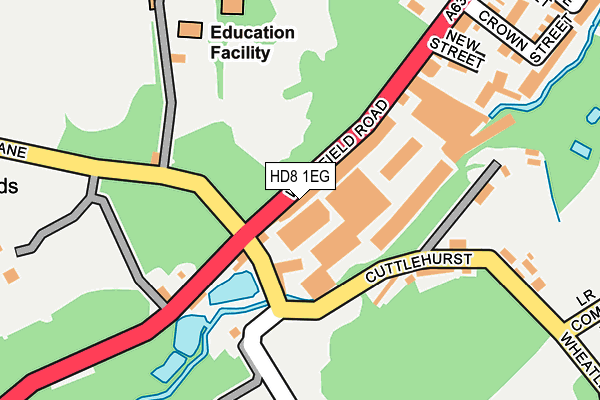
HD8 1EG is located in the Denby Dale electoral ward, within the metropolitan district of Kirklees and the English Parliamentary constituency of Dewsbury. The Sub Integrated Care Board (ICB) Location is NHS West Yorkshire ICB - X2C4Y and the police force is West Yorkshire. This postcode has been in use since May 2017.


GetTheData
Source: OS OpenMap – Local (Ordnance Survey)
Source: OS VectorMap District (Ordnance Survey)
Licence: Open Government Licence (requires attribution)
| Easting | 424663 |
| Northing | 410084 |
| Latitude | 53.586782 |
| Longitude | -1.628916 |
GetTheData
Source: Open Postcode Geo
Licence: Open Government Licence
| Country | England |
| Postcode District | HD8 |
➜ See where HD8 is on a map ➜ Where is Scissett? | |
GetTheData
Source: Land Registry Price Paid Data
Licence: Open Government Licence
| Ward | Denby Dale |
| Constituency | Dewsbury |
GetTheData
Source: ONS Postcode Database
Licence: Open Government Licence
| Wakefield Rd Highbridge Lane (Wakefield Road) | Scissett | 21m |
| Wakefield Rd Bagden Lane (Wakefield Road) | Scissett | 29m |
| Church Wakefield Road (Wakefield Road) | Scissett | 249m |
| Busker Lane | Scissett | 263m |
| Busker Lane | Scissett | 272m |
| Denby Dale Station | 2.8km |
GetTheData
Source: NaPTAN
Licence: Open Government Licence
GetTheData
Source: ONS Postcode Database
Licence: Open Government Licence


➜ Get more ratings from the Food Standards Agency
GetTheData
Source: Food Standards Agency
Licence: FSA terms & conditions
| Last Collection | |||
|---|---|---|---|
| Location | Mon-Fri | Sat | Distance |
| Cuttlehurst | 17:00 | 11:15 | 74m |
| 163 Wakefield Road | 17:00 | 11:45 | 419m |
| Sunnymead | 16:30 | 11:00 | 804m |
GetTheData
Source: Dracos
Licence: Creative Commons Attribution-ShareAlike
The below table lists the International Territorial Level (ITL) codes (formerly Nomenclature of Territorial Units for Statistics (NUTS) codes) and Local Administrative Units (LAU) codes for HD8 1EG:
| ITL 1 Code | Name |
|---|---|
| TLE | Yorkshire and The Humber |
| ITL 2 Code | Name |
| TLE4 | West Yorkshire |
| ITL 3 Code | Name |
| TLE44 | Calderdale and Kirklees |
| LAU 1 Code | Name |
| E08000034 | Kirklees |
GetTheData
Source: ONS Postcode Directory
Licence: Open Government Licence
The below table lists the Census Output Area (OA), Lower Layer Super Output Area (LSOA), and Middle Layer Super Output Area (MSOA) for HD8 1EG:
| Code | Name | |
|---|---|---|
| OA | E00055997 | |
| LSOA | E01011110 | Kirklees 057A |
| MSOA | E02002327 | Kirklees 057 |
GetTheData
Source: ONS Postcode Directory
Licence: Open Government Licence
| HD8 9LB | Highbridge | 79m |
| HD8 9JZ | Wakefield Road | 142m |
| HD8 9LF | Cuttlehurst | 163m |
| HD8 9JP | New Street | 206m |
| HD8 9JL | Stanhope Street | 239m |
| HD8 9JN | Crown Street | 285m |
| HD8 9JW | Crown Villas | 286m |
| HD8 9JU | Busker Lane | 300m |
| HD8 9JY | Highbridge Lane | 315m |
| HD8 9JT | Church Terrace | 324m |
GetTheData
Source: Open Postcode Geo; Land Registry Price Paid Data
Licence: Open Government Licence