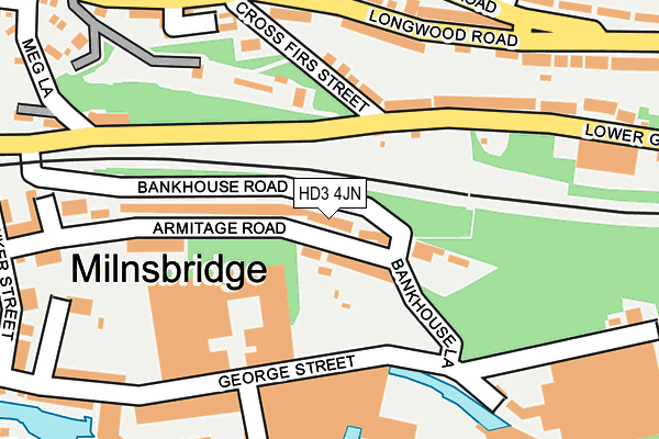
HD3 4JN lies on Armitage Road in Milnsbridge, Huddersfield. HD3 4JN is located in the Golcar electoral ward, within the metropolitan district of Kirklees and the English Parliamentary constituency of Colne Valley. The Sub Integrated Care Board (ICB) Location is NHS West Yorkshire ICB - X2C4Y and the police force is West Yorkshire. This postcode has been in use since October 1985.


GetTheData
Source: OS OpenMap – Local (Ordnance Survey)
Source: OS VectorMap District (Ordnance Survey)
Licence: Open Government Licence (requires attribution)
| Easting | 411948 |
| Northing | 416161 |
| Latitude | 53.641828 |
| Longitude | -1.820753 |
GetTheData
Source: Open Postcode Geo
Licence: Open Government Licence
| Street | Armitage Road |
| Locality | Milnsbridge |
| Town/City | Huddersfield |
| Country | England |
| Postcode District | HD3 |
➜ See where HD3 is on a map ➜ Where is Huddersfield? | |
GetTheData
Source: Land Registry Price Paid Data
Licence: Open Government Licence
Elevation or altitude of HD3 4JN as distance above sea level:
| Metres | Feet | |
|---|---|---|
| Elevation | 110m | 361ft |
Elevation is measured from the approximate centre of the postcode, to the nearest point on an OS contour line from OS Terrain 50, which has contour spacing of ten vertical metres.
➜ How high above sea level am I? Find the elevation of your current position using your device's GPS.
GetTheData
Source: Open Postcode Elevation
Licence: Open Government Licence
| Ward | Golcar |
| Constituency | Colne Valley |
GetTheData
Source: ONS Postcode Database
Licence: Open Government Licence
20, ARMITAGE ROAD, MILNSBRIDGE, HUDDERSFIELD, HD3 4JN 1996 15 AUG £25,000 |
GetTheData
Source: HM Land Registry Price Paid Data
Licence: Contains HM Land Registry data © Crown copyright and database right 2025. This data is licensed under the Open Government Licence v3.0.
| Lower Gate Cross Firs Street (Lower Gate) | Paddock | 134m |
| Lower Gate Cross Firs Street (Lower Gate) | Paddock | 186m |
| Lower Gate Meg Lane (Lowergate) | Milnsbridge | 202m |
| Longwood Rd Harp Road (Longwood Road) | Paddock | 202m |
| Longwood Rd Harp Road (Longwood Road) | Paddock | 218m |
| Lockwood Station | 1.5km |
| Huddersfield Station | 2.5km |
| Berry Brow Station | 2.9km |
GetTheData
Source: NaPTAN
Licence: Open Government Licence
| Percentage of properties with Next Generation Access | 100.0% |
| Percentage of properties with Superfast Broadband | 100.0% |
| Percentage of properties with Ultrafast Broadband | 0.0% |
| Percentage of properties with Full Fibre Broadband | 0.0% |
Superfast Broadband is between 30Mbps and 300Mbps
Ultrafast Broadband is > 300Mbps
| Median download speed | 38.2Mbps |
| Average download speed | 32.7Mbps |
| Maximum download speed | 70.62Mbps |
| Median upload speed | 7.2Mbps |
| Average upload speed | 5.9Mbps |
| Maximum upload speed | 19.99Mbps |
| Percentage of properties unable to receive 2Mbps | 0.0% |
| Percentage of properties unable to receive 5Mbps | 0.0% |
| Percentage of properties unable to receive 10Mbps | 0.0% |
| Percentage of properties unable to receive 30Mbps | 0.0% |
GetTheData
Source: Ofcom
Licence: Ofcom Terms of Use (requires attribution)
Estimated total energy consumption in HD3 4JN by fuel type, 2015.
| Consumption (kWh) | 569,306 |
|---|---|
| Meter count | 49 |
| Mean (kWh/meter) | 11,618 |
| Median (kWh/meter) | 11,685 |
| Consumption (kWh) | 179,872 |
|---|---|
| Meter count | 46 |
| Mean (kWh/meter) | 3,910 |
| Median (kWh/meter) | 3,284 |
GetTheData
Source: Postcode level gas estimates: 2015 (experimental)
Source: Postcode level electricity estimates: 2015 (experimental)
Licence: Open Government Licence
GetTheData
Source: ONS Postcode Database
Licence: Open Government Licence


➜ Get more ratings from the Food Standards Agency
GetTheData
Source: Food Standards Agency
Licence: FSA terms & conditions
| Last Collection | |||
|---|---|---|---|
| Location | Mon-Fri | Sat | Distance |
| Paddock P.o. Box | 17:30 | 12:15 | 675m |
| Rufford Road | 17:00 | 12:00 | 908m |
| 90 Luck Lane | 17:30 | 12:00 | 912m |
GetTheData
Source: Dracos
Licence: Creative Commons Attribution-ShareAlike
The below table lists the International Territorial Level (ITL) codes (formerly Nomenclature of Territorial Units for Statistics (NUTS) codes) and Local Administrative Units (LAU) codes for HD3 4JN:
| ITL 1 Code | Name |
|---|---|
| TLE | Yorkshire and The Humber |
| ITL 2 Code | Name |
| TLE4 | West Yorkshire |
| ITL 3 Code | Name |
| TLE44 | Calderdale and Kirklees |
| LAU 1 Code | Name |
| E08000034 | Kirklees |
GetTheData
Source: ONS Postcode Directory
Licence: Open Government Licence
The below table lists the Census Output Area (OA), Lower Layer Super Output Area (LSOA), and Middle Layer Super Output Area (MSOA) for HD3 4JN:
| Code | Name | |
|---|---|---|
| OA | E00056178 | |
| LSOA | E01011149 | Kirklees 045B |
| MSOA | E02002315 | Kirklees 045 |
GetTheData
Source: ONS Postcode Directory
Licence: Open Government Licence
| HD3 4EW | Lowergate | 122m |
| HD3 4EN | Cross Firs Street | 137m |
| HD3 4JW | Armitage Road | 164m |
| HD3 4EH | Longwood Road | 176m |
| HD3 4EP | Lowergate | 181m |
| HD3 4EJ | Longwood Road | 208m |
| HD3 4HR | Crown Square | 211m |
| HD3 4JD | George Street | 231m |
| HD3 4HQ | Quarmby Road | 241m |
| HD3 4HG | Quarmby Road | 254m |
GetTheData
Source: Open Postcode Geo; Land Registry Price Paid Data
Licence: Open Government Licence