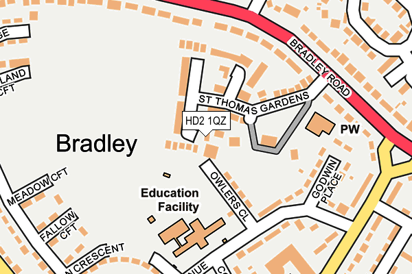
HD2 1QZ is located in the Ashbrow electoral ward, within the metropolitan district of Kirklees and the English Parliamentary constituency of Huddersfield. The Sub Integrated Care Board (ICB) Location is NHS West Yorkshire ICB - X2C4Y and the police force is West Yorkshire. This postcode has been in use since January 1980.


GetTheData
Source: OS OpenMap – Local (Ordnance Survey)
Source: OS VectorMap District (Ordnance Survey)
Licence: Open Government Licence (requires attribution)
| Easting | 416787 |
| Northing | 420504 |
| Latitude | 53.680731 |
| Longitude | -1.747328 |
GetTheData
Source: Open Postcode Geo
Licence: Open Government Licence
| Country | England |
| Postcode District | HD2 |
➜ See where HD2 is on a map ➜ Where is Huddersfield? | |
GetTheData
Source: Land Registry Price Paid Data
Licence: Open Government Licence
Elevation or altitude of HD2 1QZ as distance above sea level:
| Metres | Feet | |
|---|---|---|
| Elevation | 90m | 295ft |
Elevation is measured from the approximate centre of the postcode, to the nearest point on an OS contour line from OS Terrain 50, which has contour spacing of ten vertical metres.
➜ How high above sea level am I? Find the elevation of your current position using your device's GPS.
GetTheData
Source: Open Postcode Elevation
Licence: Open Government Licence
| Ward | Ashbrow |
| Constituency | Huddersfield |
GetTheData
Source: ONS Postcode Database
Licence: Open Government Licence
| Bradley Rd St Thomas Gardens (Bradley Road) | Bradley | 177m |
| Bradley Rd St Thomas Gardens (Bradley Road) | Bradley | 195m |
| Bradley Road Park Hill (Bradley Road) | Bradley | 252m |
| Keldregate Sherwood Ave (Keldregate) | Bradley | 256m |
| Keldregate Woodman Ave (Keldregate) | Bradley | 257m |
| Deighton Station | 1.4km |
| Brighouse Station | 2.9km |
| Mirfield Station | 3.8km |
GetTheData
Source: NaPTAN
Licence: Open Government Licence
GetTheData
Source: ONS Postcode Database
Licence: Open Government Licence


➜ Get more ratings from the Food Standards Agency
GetTheData
Source: Food Standards Agency
Licence: FSA terms & conditions
| Last Collection | |||
|---|---|---|---|
| Location | Mon-Fri | Sat | Distance |
| Park Hill Bradley | 17:15 | 12:00 | 235m |
| Alandale Road | 17:15 | 12:00 | 382m |
| 194 Deighton Road | 17:15 | 12:00 | 976m |
GetTheData
Source: Dracos
Licence: Creative Commons Attribution-ShareAlike
The below table lists the International Territorial Level (ITL) codes (formerly Nomenclature of Territorial Units for Statistics (NUTS) codes) and Local Administrative Units (LAU) codes for HD2 1QZ:
| ITL 1 Code | Name |
|---|---|
| TLE | Yorkshire and The Humber |
| ITL 2 Code | Name |
| TLE4 | West Yorkshire |
| ITL 3 Code | Name |
| TLE44 | Calderdale and Kirklees |
| LAU 1 Code | Name |
| E08000034 | Kirklees |
GetTheData
Source: ONS Postcode Directory
Licence: Open Government Licence
The below table lists the Census Output Area (OA), Lower Layer Super Output Area (LSOA), and Middle Layer Super Output Area (MSOA) for HD2 1QZ:
| Code | Name | |
|---|---|---|
| OA | E00055949 | |
| LSOA | E01011108 | Kirklees 022D |
| MSOA | E02002292 | Kirklees 022 |
GetTheData
Source: ONS Postcode Directory
Licence: Open Government Licence
| HD2 1SL | St Thomas Gardens | 73m |
| HD2 1RG | Owlers Close | 84m |
| HD2 1QU | Bradley Road | 159m |
| HD2 1RE | Godwin Place | 166m |
| HD2 1RF | Sherwood Avenue | 172m |
| HD2 1RH | Copthorne Gardens | 201m |
| HD2 1RA | Bradley Road | 206m |
| HD2 1QT | Bradley Road | 224m |
| HD2 1RL | Staynton Crescent | 239m |
| HD2 1RQ | Sherwood Avenue | 240m |
GetTheData
Source: Open Postcode Geo; Land Registry Price Paid Data
Licence: Open Government Licence