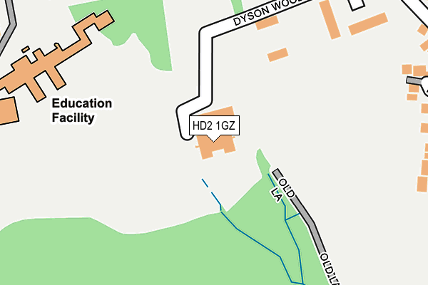
HD2 1GZ is located in the Ashbrow electoral ward, within the metropolitan district of Kirklees and the English Parliamentary constituency of Huddersfield. The Sub Integrated Care Board (ICB) Location is NHS West Yorkshire ICB - X2C4Y and the police force is West Yorkshire. This postcode has been in use since February 2010.


GetTheData
Source: OS OpenMap – Local (Ordnance Survey)
Source: OS VectorMap District (Ordnance Survey)
Licence: Open Government Licence (requires attribution)
| Easting | 415609 |
| Northing | 420282 |
| Latitude | 53.678787 |
| Longitude | -1.765175 |
GetTheData
Source: Open Postcode Geo
Licence: Open Government Licence
| Country | England |
| Postcode District | HD2 |
➜ See where HD2 is on a map ➜ Where is Huddersfield? | |
GetTheData
Source: Land Registry Price Paid Data
Licence: Open Government Licence
Elevation or altitude of HD2 1GZ as distance above sea level:
| Metres | Feet | |
|---|---|---|
| Elevation | 140m | 459ft |
Elevation is measured from the approximate centre of the postcode, to the nearest point on an OS contour line from OS Terrain 50, which has contour spacing of ten vertical metres.
➜ How high above sea level am I? Find the elevation of your current position using your device's GPS.
GetTheData
Source: Open Postcode Elevation
Licence: Open Government Licence
| Ward | Ashbrow |
| Constituency | Huddersfield |
GetTheData
Source: ONS Postcode Database
Licence: Open Government Licence
| Redwood Park (Bradley Road) | Bradley Bar | 239m |
| All Saints High School (All Saints High Rc School Grounds - Stop A) | Bradley Bar | 410m |
| All Saints High School (All Saints High Rc School Grounds - Stop B) | Bradley Bar | 414m |
| All Saints High School (All Saints High Rc School Grounds - Stop C) | Bradley Bar | 423m |
| All Saints High School (All Saints High Rc School Grounds - Stop D) | Bradley Bar | 435m |
| Deighton Station | 1.4km |
| Brighouse Station | 2.4km |
| Huddersfield Station | 3.6km |
GetTheData
Source: NaPTAN
Licence: Open Government Licence
GetTheData
Source: ONS Postcode Database
Licence: Open Government Licence

➜ Get more ratings from the Food Standards Agency
GetTheData
Source: Food Standards Agency
Licence: FSA terms & conditions
| Last Collection | |||
|---|---|---|---|
| Location | Mon-Fri | Sat | Distance |
| Alandale Road | 17:15 | 12:00 | 818m |
| Sheepridge P.o. Box | 17:15 | 11:45 | 981m |
| 1 Browning Road | 17:15 | 12:00 | 1,178m |
GetTheData
Source: Dracos
Licence: Creative Commons Attribution-ShareAlike
The below table lists the International Territorial Level (ITL) codes (formerly Nomenclature of Territorial Units for Statistics (NUTS) codes) and Local Administrative Units (LAU) codes for HD2 1GZ:
| ITL 1 Code | Name |
|---|---|
| TLE | Yorkshire and The Humber |
| ITL 2 Code | Name |
| TLE4 | West Yorkshire |
| ITL 3 Code | Name |
| TLE44 | Calderdale and Kirklees |
| LAU 1 Code | Name |
| E08000034 | Kirklees |
GetTheData
Source: ONS Postcode Directory
Licence: Open Government Licence
The below table lists the Census Output Area (OA), Lower Layer Super Output Area (LSOA), and Middle Layer Super Output Area (MSOA) for HD2 1GZ:
| Code | Name | |
|---|---|---|
| OA | E00055948 | |
| LSOA | E01011102 | Kirklees 022C |
| MSOA | E02002292 | Kirklees 022 |
GetTheData
Source: ONS Postcode Directory
Licence: Open Government Licence
| HD2 1GN | Dyson Wood Way | 14m |
| HD2 1PX | Bradley Road | 169m |
| HD2 1JQ | Brier Hill View | 194m |
| HD2 1NA | Miramar | 199m |
| HD2 1PU | Bradley Road | 220m |
| HD2 1GQ | Longbow Close | 235m |
| HD2 1PR | Bradley Road | 286m |
| HD2 1LZ | Grantley Place | 302m |
| HD2 1PS | Bradley Road | 329m |
| HD2 1PW | Redwood Drive | 376m |
GetTheData
Source: Open Postcode Geo; Land Registry Price Paid Data
Licence: Open Government Licence