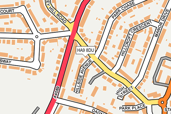
HA9 8DU lies on Wembley Hill Road in Wembley. HA9 8DU is located in the Wembley Hill electoral ward, within the London borough of Brent and the English Parliamentary constituency of Brent Central. The Sub Integrated Care Board (ICB) Location is NHS North West London ICB - W2U3Z and the police force is Metropolitan Police. This postcode has been in use since May 2021.


GetTheData
Source: OS OpenMap – Local (Ordnance Survey)
Source: OS VectorMap District (Ordnance Survey)
Licence: Open Government Licence (requires attribution)
| Easting | 518643 |
| Northing | 185799 |
| Latitude | 51.558607 |
| Longitude | -0.289929 |
GetTheData
Source: Open Postcode Geo
Licence: Open Government Licence
| Street | Wembley Hill Road |
| Town/City | Wembley |
| Country | England |
| Postcode District | HA9 |
➜ See where HA9 is on a map ➜ Where is Wembley? | |
GetTheData
Source: Land Registry Price Paid Data
Licence: Open Government Licence
Elevation or altitude of HA9 8DU as distance above sea level:
| Metres | Feet | |
|---|---|---|
| Elevation | 60m | 197ft |
Elevation is measured from the approximate centre of the postcode, to the nearest point on an OS contour line from OS Terrain 50, which has contour spacing of ten vertical metres.
➜ How high above sea level am I? Find the elevation of your current position using your device's GPS.
GetTheData
Source: Open Postcode Elevation
Licence: Open Government Licence
| Ward | Wembley Hill |
| Constituency | Brent Central |
GetTheData
Source: ONS Postcode Database
Licence: Open Government Licence
147, WEMBLEY HILL ROAD, WEMBLEY, HA9 8DU 1997 21 OCT £202,500 |
GetTheData
Source: HM Land Registry Price Paid Data
Licence: Contains HM Land Registry data © Crown copyright and database right 2025. This data is licensed under the Open Government Licence v3.0.
| Wembley Hill Road Park Lane (Park Lane) | Wembley | 70m |
| Park Lane Wembley Hill Road | North Wembley | 156m |
| Wembley Hill Road Park Lane (Wembley Park Drive) | Wembley | 162m |
| Dagmar Avenue (Park Lane) | Wembley | 174m |
| Balmoral Court (Wembley Park Drive) | Wembley Park | 293m |
| Wembley Central Underground Station | Wembley | 849m |
| Wembley Park Underground Station | Wembley Park | 900m |
| North Wembley Underground Station | North Wembley | 1,068m |
| Preston Road Underground Station | Preston | 1,529m |
| South Kenton Underground Station | South Kenton | 1,820m |
| Wembley Stadium Station | 0.6km |
| Wembley Central Station | 0.8km |
| North Wembley Station | 1.1km |
GetTheData
Source: NaPTAN
Licence: Open Government Licence
GetTheData
Source: ONS Postcode Database
Licence: Open Government Licence


➜ Get more ratings from the Food Standards Agency
GetTheData
Source: Food Standards Agency
Licence: FSA terms & conditions
| Last Collection | |||
|---|---|---|---|
| Location | Mon-Fri | Sat | Distance |
| 116 Wembley Hill Road | 17:00 | 12:15 | 144m |
| Empire Way | 17:00 | 12:45 | 376m |
| Wembley Hill Road | 17:15 | 12:30 | 379m |
GetTheData
Source: Dracos
Licence: Creative Commons Attribution-ShareAlike
The below table lists the International Territorial Level (ITL) codes (formerly Nomenclature of Territorial Units for Statistics (NUTS) codes) and Local Administrative Units (LAU) codes for HA9 8DU:
| ITL 1 Code | Name |
|---|---|
| TLI | London |
| ITL 2 Code | Name |
| TLI7 | Outer London - West and North West |
| ITL 3 Code | Name |
| TLI72 | Brent |
| LAU 1 Code | Name |
| E09000005 | Brent |
GetTheData
Source: ONS Postcode Directory
Licence: Open Government Licence
The below table lists the Census Output Area (OA), Lower Layer Super Output Area (LSOA), and Middle Layer Super Output Area (MSOA) for HA9 8DU:
| Code | Name | |
|---|---|---|
| OA | E00002974 | |
| LSOA | E01000616 | Brent 020A |
| MSOA | E02000112 | Brent 020 |
GetTheData
Source: ONS Postcode Directory
Licence: Open Government Licence
| HA9 8DY | Hillside Avenue | 62m |
| HA9 8EJ | Wembley Hill Road | 63m |
| HA9 7SB | Park Lane | 77m |
| HA9 8DZ | Wembley Hill Road | 78m |
| HA9 7RZ | Park Lane | 99m |
| HA9 8DT | Wembley Hill Road | 119m |
| HA9 7QY | Clarendon Gardens | 151m |
| HA9 8EA | Wembley Hill Road | 153m |
| HA9 8HA | Wembley Park Drive | 166m |
| HA9 8EE | Hillcroft Crescent | 174m |
GetTheData
Source: Open Postcode Geo; Land Registry Price Paid Data
Licence: Open Government Licence