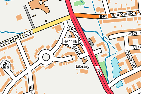
HA7 1RB is located in the Centenary electoral ward, within the London borough of Harrow and the English Parliamentary constituency of Harrow East. The Sub Integrated Care Board (ICB) Location is NHS North West London ICB - W2U3Z and the police force is Metropolitan Police. This postcode has been in use since March 2003.


GetTheData
Source: OS OpenMap – Local (Ordnance Survey)
Source: OS VectorMap District (Ordnance Survey)
Licence: Open Government Licence (requires attribution)
| Easting | 517733 |
| Northing | 191063 |
| Latitude | 51.606105 |
| Longitude | -0.301309 |
GetTheData
Source: Open Postcode Geo
Licence: Open Government Licence
| Country | England |
| Postcode District | HA7 |
➜ See where HA7 is on a map ➜ Where is Stanmore? | |
GetTheData
Source: Land Registry Price Paid Data
Licence: Open Government Licence
Elevation or altitude of HA7 1RB as distance above sea level:
| Metres | Feet | |
|---|---|---|
| Elevation | 70m | 230ft |
Elevation is measured from the approximate centre of the postcode, to the nearest point on an OS contour line from OS Terrain 50, which has contour spacing of ten vertical metres.
➜ How high above sea level am I? Find the elevation of your current position using your device's GPS.
GetTheData
Source: Open Postcode Elevation
Licence: Open Government Licence
| Ward | Centenary |
| Constituency | Harrow East |
GetTheData
Source: ONS Postcode Database
Licence: Open Government Licence
| Honeypot Lane Centre (Honeypot Lane) | Canons Park | 87m |
| Wemborough Road (Honeypot Lane) | Canons Park | 91m |
| Marsh Lane (Whitchurch Lane) | Canons Park | 152m |
| Marsh Lane (Whitchurch Lane) | Canons Park | 161m |
| Abercorn Road Canons Park (Wemborough Road) | Canons Park | 345m |
| Canons Park Underground Station | Canons Park | 491m |
| Queensbury Underground Station | Queensbury | 1,688m |
| Harrow & Wealdstone Station | 2.8km |
| Kenton Station | 2.9km |
| Mill Hill Broadway Station | 3.7km |
GetTheData
Source: NaPTAN
Licence: Open Government Licence
GetTheData
Source: ONS Postcode Database
Licence: Open Government Licence


➜ Get more ratings from the Food Standards Agency
GetTheData
Source: Food Standards Agency
Licence: FSA terms & conditions
| Last Collection | |||
|---|---|---|---|
| Location | Mon-Fri | Sat | Distance |
| Honeypot Lane Post Office | 18:45 | 12:30 | 53m |
| Bromerfield | 18:15 | 12:30 | 373m |
| Marsh Lane | 18:00 | 12:45 | 491m |
GetTheData
Source: Dracos
Licence: Creative Commons Attribution-ShareAlike
| Risk of HA7 1RB flooding from rivers and sea | Medium |
| ➜ HA7 1RB flood map | |
GetTheData
Source: Open Flood Risk by Postcode
Licence: Open Government Licence
The below table lists the International Territorial Level (ITL) codes (formerly Nomenclature of Territorial Units for Statistics (NUTS) codes) and Local Administrative Units (LAU) codes for HA7 1RB:
| ITL 1 Code | Name |
|---|---|
| TLI | London |
| ITL 2 Code | Name |
| TLI7 | Outer London - West and North West |
| ITL 3 Code | Name |
| TLI74 | Harrow and Hillingdon |
| LAU 1 Code | Name |
| E09000015 | Harrow |
GetTheData
Source: ONS Postcode Directory
Licence: Open Government Licence
The below table lists the Census Output Area (OA), Lower Layer Super Output Area (LSOA), and Middle Layer Super Output Area (MSOA) for HA7 1RB:
| Code | Name | |
|---|---|---|
| OA | E00010594 | |
| LSOA | E01002110 | Harrow 008D |
| MSOA | E02000440 | Harrow 008 |
GetTheData
Source: ONS Postcode Directory
Licence: Open Government Licence
| HA7 1AR | Honeypot Lane | 35m |
| HA7 1AL | Bromefield | 40m |
| HA7 1AJ | Bromefield | 65m |
| HA7 1AD | Maychurch Close | 67m |
| HA7 1AA | Bromefield | 93m |
| HA7 1AH | Honeypot Lane | 97m |
| HA7 1AB | Bromefield | 117m |
| HA7 1QX | Bramble Close | 147m |
| HA7 2DU | Wemborough Road | 166m |
| HA8 6QZ | Longcrofte Road | 198m |
GetTheData
Source: Open Postcode Geo; Land Registry Price Paid Data
Licence: Open Government Licence