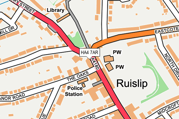
HA4 7AR is located in the Ruislip electoral ward, within the London borough of Hillingdon and the English Parliamentary constituency of Ruislip, Northwood and Pinner. The Sub Integrated Care Board (ICB) Location is NHS North West London ICB - W2U3Z and the police force is Metropolitan Police. This postcode has been in use since January 1980.


GetTheData
Source: OS OpenMap – Local (Ordnance Survey)
Source: OS VectorMap District (Ordnance Survey)
Licence: Open Government Licence (requires attribution)
| Easting | 509090 |
| Northing | 187601 |
| Latitude | 51.576729 |
| Longitude | -0.427117 |
GetTheData
Source: Open Postcode Geo
Licence: Open Government Licence
| Country | England |
| Postcode District | HA4 |
➜ See where HA4 is on a map ➜ Where is Ruislip? | |
GetTheData
Source: Land Registry Price Paid Data
Licence: Open Government Licence
Elevation or altitude of HA4 7AR as distance above sea level:
| Metres | Feet | |
|---|---|---|
| Elevation | 50m | 164ft |
Elevation is measured from the approximate centre of the postcode, to the nearest point on an OS contour line from OS Terrain 50, which has contour spacing of ten vertical metres.
➜ How high above sea level am I? Find the elevation of your current position using your device's GPS.
GetTheData
Source: Open Postcode Elevation
Licence: Open Government Licence
| Ward | Ruislip |
| Constituency | Ruislip, Northwood And Pinner |
GetTheData
Source: ONS Postcode Database
Licence: Open Government Licence
| The Oaks | Ruislip | 58m |
| Ruislip Police Station (The Oaks) | Ruislip | 65m |
| The Oaks | Ruislip | 139m |
| Neats Acre (Sharps Lane) | Ruislip | 228m |
| Ruislip Young People's Centre (Bury Street) | Ruislip | 271m |
| Ruislip Underground Station | Ruislip | 700m |
| Ruislip Manor Underground Station | Ruislip Manor | 1,057m |
| West Ruislip Underground Station | West Ruislip | 1,081m |
| Woody Bay (Ruislip Lido Railway) (Ruislip Lido) | Ruislip Common | 1,408m |
| West Ruislip Station | 1.1km |
| South Ruislip Station | 2.9km |
| Denham Station | 4.9km |
GetTheData
Source: NaPTAN
Licence: Open Government Licence
GetTheData
Source: ONS Postcode Database
Licence: Open Government Licence


➜ Get more ratings from the Food Standards Agency
GetTheData
Source: Food Standards Agency
Licence: FSA terms & conditions
| Last Collection | |||
|---|---|---|---|
| Location | Mon-Fri | Sat | Distance |
| Sharps Lane | 18:15 | 13:00 | 402m |
| Evelyn Avenue | 18:15 | 12:45 | 530m |
| Ruislip Delivery Office | 19:00 | 12:45 | 540m |
GetTheData
Source: Dracos
Licence: Creative Commons Attribution-ShareAlike
The below table lists the International Territorial Level (ITL) codes (formerly Nomenclature of Territorial Units for Statistics (NUTS) codes) and Local Administrative Units (LAU) codes for HA4 7AR:
| ITL 1 Code | Name |
|---|---|
| TLI | London |
| ITL 2 Code | Name |
| TLI7 | Outer London - West and North West |
| ITL 3 Code | Name |
| TLI74 | Harrow and Hillingdon |
| LAU 1 Code | Name |
| E09000017 | Hillingdon |
GetTheData
Source: ONS Postcode Directory
Licence: Open Government Licence
The below table lists the Census Output Area (OA), Lower Layer Super Output Area (LSOA), and Middle Layer Super Output Area (MSOA) for HA4 7AR:
| Code | Name | |
|---|---|---|
| OA | E00012638 | |
| LSOA | E01002535 | Hillingdon 007E |
| MSOA | E02000500 | Hillingdon 007 |
GetTheData
Source: ONS Postcode Directory
Licence: Open Government Licence
| HA4 7LF | The Oaks | 58m |
| HA4 7LH | The Oaks | 82m |
| HA4 7AN | High Street | 102m |
| HA4 8DG | Eastcote Road | 140m |
| HA4 7AJ | King Edwards Road | 194m |
| HA4 7HT | Church Avenue | 195m |
| HA4 8BE | Eastcote Road | 205m |
| HA4 7QD | St Martins Approach | 208m |
| HA4 7BD | High Street | 212m |
| HA4 7HU | Church Avenue | 218m |
GetTheData
Source: Open Postcode Geo; Land Registry Price Paid Data
Licence: Open Government Licence