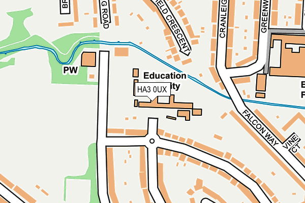
HA3 0UX is located in the Kenton electoral ward, within the London borough of Brent and the English Parliamentary constituency of Brent North. The Sub Integrated Care Board (ICB) Location is NHS North West London ICB - W2U3Z and the police force is Metropolitan Police. This postcode has been in use since January 1995.


GetTheData
Source: OS OpenMap – Local (Ordnance Survey)
Source: OS VectorMap District (Ordnance Survey)
Licence: Open Government Licence (requires attribution)
| Easting | 518023 |
| Northing | 188541 |
| Latitude | 51.583378 |
| Longitude | -0.297971 |
GetTheData
Source: Open Postcode Geo
Licence: Open Government Licence
| Country | England |
| Postcode District | HA3 |
➜ See where HA3 is on a map ➜ Where is Kenton? | |
GetTheData
Source: Land Registry Price Paid Data
Licence: Open Government Licence
Elevation or altitude of HA3 0UX as distance above sea level:
| Metres | Feet | |
|---|---|---|
| Elevation | 40m | 131ft |
Elevation is measured from the approximate centre of the postcode, to the nearest point on an OS contour line from OS Terrain 50, which has contour spacing of ten vertical metres.
➜ How high above sea level am I? Find the elevation of your current position using your device's GPS.
GetTheData
Source: Open Postcode Elevation
Licence: Open Government Licence
| Ward | Kenton |
| Constituency | Brent North |
GetTheData
Source: ONS Postcode Database
Licence: Open Government Licence
| Charlton Road | Kenton | 379m |
| Charlton Road | Kenton | 393m |
| Shrewsbury Avenue | Kenton | 440m |
| Shrewsbury Avenue | Kenton | 504m |
| Kenton Park Avenue | Kenton | 543m |
| Preston Road Underground Station | Preston | 1,284m |
| Kenton Underground Station | Kenton | 1,325m |
| Kingsbury Underground Station | Kingsbury | 1,339m |
| Queensbury Underground Station | Queensbury | 1,452m |
| Northwick Park Underground Station | Northwick Park | 1,495m |
| Kenton Station | 1.3km |
| South Kenton Station | 1.6km |
| North Wembley Station | 2.3km |
GetTheData
Source: NaPTAN
Licence: Open Government Licence
GetTheData
Source: ONS Postcode Database
Licence: Open Government Licence


➜ Get more ratings from the Food Standards Agency
GetTheData
Source: Food Standards Agency
Licence: FSA terms & conditions
| Last Collection | |||
|---|---|---|---|
| Location | Mon-Fri | Sat | Distance |
| Shrewsbury Avenue | 17:30 | 11:45 | 343m |
| Kenton Road | 17:00 | 12:00 | 451m |
| Ebrington Road | 17:45 | 11:45 | 460m |
GetTheData
Source: Dracos
Licence: Creative Commons Attribution-ShareAlike
| Risk of HA3 0UX flooding from rivers and sea | Low |
| ➜ HA3 0UX flood map | |
GetTheData
Source: Open Flood Risk by Postcode
Licence: Open Government Licence
The below table lists the International Territorial Level (ITL) codes (formerly Nomenclature of Territorial Units for Statistics (NUTS) codes) and Local Administrative Units (LAU) codes for HA3 0UX:
| ITL 1 Code | Name |
|---|---|
| TLI | London |
| ITL 2 Code | Name |
| TLI7 | Outer London - West and North West |
| ITL 3 Code | Name |
| TLI72 | Brent |
| LAU 1 Code | Name |
| E09000005 | Brent |
GetTheData
Source: ONS Postcode Directory
Licence: Open Government Licence
The below table lists the Census Output Area (OA), Lower Layer Super Output Area (LSOA), and Middle Layer Super Output Area (MSOA) for HA3 0UX:
| Code | Name | |
|---|---|---|
| OA | E00002629 | |
| LSOA | E01033463 | Brent 003G |
| MSOA | E02000095 | Brent 003 |
GetTheData
Source: ONS Postcode Directory
Licence: Open Government Licence
| HA3 0SH | Regal Way | 76m |
| HA3 0UT | Brookfield Crescent | 157m |
| HA3 0TS | Greenway | 173m |
| HA3 0SQ | Regal Way | 192m |
| HA3 0RF | Shaftesbury Avenue | 200m |
| HA3 0UW | Cranleigh Gardens | 203m |
| HA3 0YE | Lidding Road | 211m |
| HA3 0YF | Lidding Road | 215m |
| HA3 0TW | Falcon Way | 227m |
| HA3 0SN | Palace Court | 229m |
GetTheData
Source: Open Postcode Geo; Land Registry Price Paid Data
Licence: Open Government Licence