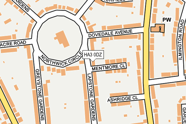
HA3 0DZ lies on Lapstone Gardens in Harrow. HA3 0DZ is located in the Kenton electoral ward, within the London borough of Brent and the English Parliamentary constituency of Brent North. The Sub Integrated Care Board (ICB) Location is NHS North West London ICB - W2U3Z and the police force is Metropolitan Police. This postcode has been in use since January 1980.


GetTheData
Source: OS OpenMap – Local (Ordnance Survey)
Source: OS VectorMap District (Ordnance Survey)
Licence: Open Government Licence (requires attribution)
| Easting | 517272 |
| Northing | 188287 |
| Latitude | 51.581252 |
| Longitude | -0.308890 |
GetTheData
Source: Open Postcode Geo
Licence: Open Government Licence
| Street | Lapstone Gardens |
| Town/City | Harrow |
| Country | England |
| Postcode District | HA3 |
➜ See where HA3 is on a map ➜ Where is Kenton? | |
GetTheData
Source: Land Registry Price Paid Data
Licence: Open Government Licence
Elevation or altitude of HA3 0DZ as distance above sea level:
| Metres | Feet | |
|---|---|---|
| Elevation | 50m | 164ft |
Elevation is measured from the approximate centre of the postcode, to the nearest point on an OS contour line from OS Terrain 50, which has contour spacing of ten vertical metres.
➜ How high above sea level am I? Find the elevation of your current position using your device's GPS.
GetTheData
Source: Open Postcode Elevation
Licence: Open Government Licence
| Ward | Kenton |
| Constituency | Brent North |
GetTheData
Source: ONS Postcode Database
Licence: Open Government Licence
| Dovedale Avenue (Woodcock Hill) | Preston | 184m |
| Dovedale Avenue (Woodcock Hill) | Preston | 204m |
| Woodcock Hillsedgecombe Av | Preston | 438m |
| St Leonards Avenue (Kenton Road) | Kenton | 442m |
| Odeon Parade Upton Gardens | Kenton | 447m |
| Kenton Underground Station | Kenton | 559m |
| Northwick Park Underground Station | Northwick Park | 706m |
| South Kenton Underground Station | South Kenton | 1,226m |
| Preston Road Underground Station | Preston | 1,407m |
| Kenton Station | 0.6km |
| South Kenton Station | 1.2km |
| Harrow-on-the-Hill Station | 2km |
GetTheData
Source: NaPTAN
Licence: Open Government Licence
| Percentage of properties with Next Generation Access | 100.0% |
| Percentage of properties with Superfast Broadband | 100.0% |
| Percentage of properties with Ultrafast Broadband | 100.0% |
| Percentage of properties with Full Fibre Broadband | 100.0% |
Superfast Broadband is between 30Mbps and 300Mbps
Ultrafast Broadband is > 300Mbps
| Percentage of properties unable to receive 2Mbps | 0.0% |
| Percentage of properties unable to receive 5Mbps | 0.0% |
| Percentage of properties unable to receive 10Mbps | 0.0% |
| Percentage of properties unable to receive 30Mbps | 0.0% |
GetTheData
Source: Ofcom
Licence: Ofcom Terms of Use (requires attribution)
GetTheData
Source: ONS Postcode Database
Licence: Open Government Licence


➜ Get more ratings from the Food Standards Agency
GetTheData
Source: Food Standards Agency
Licence: FSA terms & conditions
| Last Collection | |||
|---|---|---|---|
| Location | Mon-Fri | Sat | Distance |
| Northwick Circle | 17:30 | 11:30 | 206m |
| The Ridgeway | 17:30 | 11:45 | 233m |
| Woodcock Hill | 17:30 | 11:45 | 360m |
GetTheData
Source: Dracos
Licence: Creative Commons Attribution-ShareAlike
The below table lists the International Territorial Level (ITL) codes (formerly Nomenclature of Territorial Units for Statistics (NUTS) codes) and Local Administrative Units (LAU) codes for HA3 0DZ:
| ITL 1 Code | Name |
|---|---|
| TLI | London |
| ITL 2 Code | Name |
| TLI7 | Outer London - West and North West |
| ITL 3 Code | Name |
| TLI72 | Brent |
| LAU 1 Code | Name |
| E09000005 | Brent |
GetTheData
Source: ONS Postcode Directory
Licence: Open Government Licence
The below table lists the Census Output Area (OA), Lower Layer Super Output Area (LSOA), and Middle Layer Super Output Area (MSOA) for HA3 0DZ:
| Code | Name | |
|---|---|---|
| OA | E00002613 | |
| LSOA | E01000536 | Brent 004A |
| MSOA | E02000096 | Brent 004 |
GetTheData
Source: ONS Postcode Directory
Licence: Open Government Licence
| HA3 0DY | Northwick Circle | 56m |
| HA3 0EA | Mentmore Close | 77m |
| HA3 0EE | Northwick Circle | 101m |
| HA3 0EB | Lapstone Gardens | 109m |
| HA3 0ED | Lapstone Gardens | 120m |
| HA3 0DX | Dovedale Avenue | 121m |
| HA3 0JD | Woodcock Hill | 157m |
| HA3 0JE | Ashridge Close | 159m |
| HA3 0EF | Greystone Gardens | 207m |
| HA3 0EQ | Northwick Circle | 209m |
GetTheData
Source: Open Postcode Geo; Land Registry Price Paid Data
Licence: Open Government Licence