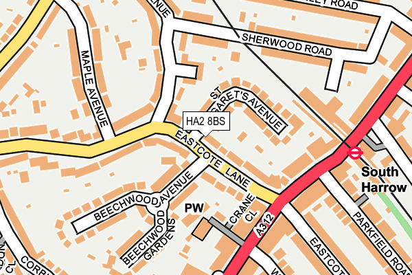
HA2 8BS is located in the Roxeth electoral ward, within the London borough of Harrow and the English Parliamentary constituency of Harrow West. The Sub Integrated Care Board (ICB) Location is NHS North West London ICB - W2U3Z and the police force is Metropolitan Police. This postcode has been in use since January 1980.


GetTheData
Source: OS OpenMap – Local (Ordnance Survey)
Source: OS VectorMap District (Ordnance Survey)
Licence: Open Government Licence (requires attribution)
| Easting | 514049 |
| Northing | 186432 |
| Latitude | 51.565242 |
| Longitude | -0.355964 |
GetTheData
Source: Open Postcode Geo
Licence: Open Government Licence
| Country | England |
| Postcode District | HA2 |
➜ See where HA2 is on a map ➜ Where is Harrow? | |
GetTheData
Source: Land Registry Price Paid Data
Licence: Open Government Licence
Elevation or altitude of HA2 8BS as distance above sea level:
| Metres | Feet | |
|---|---|---|
| Elevation | 60m | 197ft |
Elevation is measured from the approximate centre of the postcode, to the nearest point on an OS contour line from OS Terrain 50, which has contour spacing of ten vertical metres.
➜ How high above sea level am I? Find the elevation of your current position using your device's GPS.
GetTheData
Source: Open Postcode Elevation
Licence: Open Government Licence
| Ward | Roxeth |
| Constituency | Harrow West |
GetTheData
Source: ONS Postcode Database
Licence: Open Government Licence
| South Harrow (Northolt Road) | South Harrow | 159m |
| South Harrow (Northolt Road) | South Harrow | 189m |
| South Harrow (Northolt Road) | South Harrow | 213m |
| South Harrow Bus Station | South Harrow | 264m |
| South Harrow Bus Station | South Harrow | 267m |
| South Harrow Underground Station | South Harrow | 245m |
| Rayners Lane Underground Station | Rayners Lane | 1,522m |
| Sudbury Hill Underground Station | Sudbury Hill | 1,640m |
| Northolt Park Station | 0.9km |
| Sudbury Hill Harrow Station | 1.6km |
| Harrow-on-the-Hill Station | 2km |
GetTheData
Source: NaPTAN
Licence: Open Government Licence
GetTheData
Source: ONS Postcode Database
Licence: Open Government Licence


➜ Get more ratings from the Food Standards Agency
GetTheData
Source: Food Standards Agency
Licence: FSA terms & conditions
| Last Collection | |||
|---|---|---|---|
| Location | Mon-Fri | Sat | Distance |
| Waitrose | 17:30 | 12:15 | 397m |
| Scots Crescent | 17:30 | 12:30 | 587m |
| Capthorne Avenue | 18:00 | 12:00 | 689m |
GetTheData
Source: Dracos
Licence: Creative Commons Attribution-ShareAlike
The below table lists the International Territorial Level (ITL) codes (formerly Nomenclature of Territorial Units for Statistics (NUTS) codes) and Local Administrative Units (LAU) codes for HA2 8BS:
| ITL 1 Code | Name |
|---|---|
| TLI | London |
| ITL 2 Code | Name |
| TLI7 | Outer London - West and North West |
| ITL 3 Code | Name |
| TLI74 | Harrow and Hillingdon |
| LAU 1 Code | Name |
| E09000015 | Harrow |
GetTheData
Source: ONS Postcode Directory
Licence: Open Government Licence
The below table lists the Census Output Area (OA), Lower Layer Super Output Area (LSOA), and Middle Layer Super Output Area (MSOA) for HA2 8BS:
| Code | Name | |
|---|---|---|
| OA | E00011055 | |
| LSOA | E01002213 | Harrow 027D |
| MSOA | E02000459 | Harrow 027 |
GetTheData
Source: ONS Postcode Directory
Licence: Open Government Licence
| HA2 8DB | Eastcote Lane | 26m |
| HA2 8BJ | Eastcote Avenue | 38m |
| HA2 8BP | Eastcote Lane | 85m |
| HA2 8DF | Eastcote Lane | 89m |
| HA2 8DN | Barnaby Close | 89m |
| HA2 8DA | St Margarets Avenue | 98m |
| HA2 8BT | Beechwood Avenue | 99m |
| HA2 8BW | Eastcote Lane | 102m |
| HA2 8BZ | St Margarets Avenue | 112m |
| HA2 8AN | Eastcote Avenue | 125m |
GetTheData
Source: Open Postcode Geo; Land Registry Price Paid Data
Licence: Open Government Licence