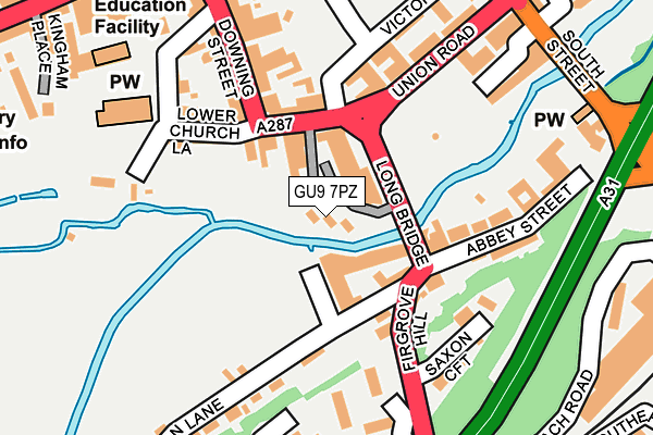
GU9 7PZ is located in the Farnham Castle electoral ward, within the local authority district of Waverley and the English Parliamentary constituency of South West Surrey. The Sub Integrated Care Board (ICB) Location is NHS Frimley ICB - D4U1Y and the police force is Surrey. This postcode has been in use since April 2017.


GetTheData
Source: OS OpenMap – Local (Ordnance Survey)
Source: OS VectorMap District (Ordnance Survey)
Licence: Open Government Licence (requires attribution)
| Easting | 484049 |
| Northing | 146581 |
| Latitude | 51.212256 |
| Longitude | -0.798084 |
GetTheData
Source: Open Postcode Geo
Licence: Open Government Licence
| Country | England |
| Postcode District | GU9 |
➜ See where GU9 is on a map ➜ Where is Farnham? | |
GetTheData
Source: Land Registry Price Paid Data
Licence: Open Government Licence
| Ward | Farnham Castle |
| Constituency | South West Surrey |
GetTheData
Source: ONS Postcode Database
Licence: Open Government Licence
| Union Road | Farnham | 152m |
| South Street | Farnham | 294m |
| The Hart (West Street) | Farnham | 295m |
| The Borough | Farnham | 300m |
| The Hart (West Street) | Farnham | 339m |
| Farnham Station | 0.4km |
| Aldershot Station | 4.6km |
| Bentley (Hants) Station | 6km |
GetTheData
Source: NaPTAN
Licence: Open Government Licence
| Median download speed | 47.5Mbps |
| Average download speed | 51.5Mbps |
| Maximum download speed | 78.94Mbps |
| Median upload speed | 10.0Mbps |
| Average upload speed | 11.8Mbps |
| Maximum upload speed | 20.00Mbps |
GetTheData
Source: Ofcom
Licence: Ofcom Terms of Use (requires attribution)
Estimated total energy consumption in GU9 7PZ by fuel type, 2015.
| Consumption (kWh) | 14,417 |
|---|---|
| Meter count | 6 |
| Mean (kWh/meter) | 2,403 |
| Median (kWh/meter) | 1 |
GetTheData
Source: Postcode level gas estimates: 2015 (experimental)
Source: Postcode level electricity estimates: 2015 (experimental)
Licence: Open Government Licence
GetTheData
Source: ONS Postcode Database
Licence: Open Government Licence


➜ Get more ratings from the Food Standards Agency
GetTheData
Source: Food Standards Agency
Licence: FSA terms & conditions
| Last Collection | |||
|---|---|---|---|
| Location | Mon-Fri | Sat | Distance |
| Downing Street | 17:30 | 12:00 | 90m |
| Trafalgar Court | 17:30 | 12:00 | 223m |
| South Street | 17:30 | 12:00 | 272m |
GetTheData
Source: Dracos
Licence: Creative Commons Attribution-ShareAlike
| Risk of GU9 7PZ flooding from rivers and sea | Medium |
| ➜ GU9 7PZ flood map | |
GetTheData
Source: Open Flood Risk by Postcode
Licence: Open Government Licence
The below table lists the International Territorial Level (ITL) codes (formerly Nomenclature of Territorial Units for Statistics (NUTS) codes) and Local Administrative Units (LAU) codes for GU9 7PZ:
| ITL 1 Code | Name |
|---|---|
| TLJ | South East (England) |
| ITL 2 Code | Name |
| TLJ2 | Surrey, East and West Sussex |
| ITL 3 Code | Name |
| TLJ25 | West Surrey |
| LAU 1 Code | Name |
| E07000216 | Waverley |
GetTheData
Source: ONS Postcode Directory
Licence: Open Government Licence
The below table lists the Census Output Area (OA), Lower Layer Super Output Area (LSOA), and Middle Layer Super Output Area (MSOA) for GU9 7PZ:
| Code | Name | |
|---|---|---|
| OA | E00157480 | |
| LSOA | E01030885 | Waverley 003B |
| MSOA | E02006441 | Waverley 003 |
GetTheData
Source: ONS Postcode Directory
Licence: Open Government Licence
| GU9 7NX | Downing Street | 61m |
| GU9 7QR | Bridge Square | 72m |
| GU9 7QP | Bridge Square | 89m |
| GU9 7PN | Downing Street | 101m |
| GU9 7RL | Abbey Street | 127m |
| GU9 7PS | Lower Church Lane | 134m |
| GU9 7RD | Victoria Road | 138m |
| GU9 7RJ | Abbey Street | 157m |
| GU9 7PB | Downing Street | 160m |
| GU9 7PH | Downing Street | 160m |
GetTheData
Source: Open Postcode Geo; Land Registry Price Paid Data
Licence: Open Government Licence