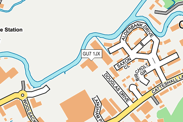
GU7 1JX lies on Douglas Drive in Godalming. GU7 1JX is located in the Godalming Central & Ockford electoral ward, within the local authority district of Waverley and the English Parliamentary constituency of South West Surrey. The Sub Integrated Care Board (ICB) Location is NHS Surrey Heartlands ICB - 92A and the police force is Surrey. This postcode has been in use since January 1992.


GetTheData
Source: OS OpenMap – Local (Ordnance Survey)
Source: OS VectorMap District (Ordnance Survey)
Licence: Open Government Licence (requires attribution)
| Easting | 497757 |
| Northing | 144085 |
| Latitude | 51.187638 |
| Longitude | -0.602569 |
GetTheData
Source: Open Postcode Geo
Licence: Open Government Licence
| Street | Douglas Drive |
| Town/City | Godalming |
| Country | England |
| Postcode District | GU7 |
➜ See where GU7 is on a map ➜ Where is Godalming? | |
GetTheData
Source: Land Registry Price Paid Data
Licence: Open Government Licence
Elevation or altitude of GU7 1JX as distance above sea level:
| Metres | Feet | |
|---|---|---|
| Elevation | 40m | 131ft |
Elevation is measured from the approximate centre of the postcode, to the nearest point on an OS contour line from OS Terrain 50, which has contour spacing of ten vertical metres.
➜ How high above sea level am I? Find the elevation of your current position using your device's GPS.
GetTheData
Source: Open Postcode Elevation
Licence: Open Government Licence
| Ward | Godalming Central & Ockford |
| Constituency | South West Surrey |
GetTheData
Source: ONS Postcode Database
Licence: Open Government Licence
| Langham Close (Catteshall Lane) | Catteshall | 186m |
| Langham Close (Catteshall Lane) | Catteshall | 194m |
| Sainsburys (Flambard Way) | Godalming | 239m |
| Sainsburys (Woolsack Way) | Godalming | 257m |
| Wharf Nursery School (Woolsack Way) | Godalming | 312m |
| Farncombe Station | 1.1km |
| Godalming Station | 1.1km |
| Milford (Surrey) Station | 3.6km |
GetTheData
Source: NaPTAN
Licence: Open Government Licence
| Median download speed | 74.0Mbps |
| Average download speed | 54.7Mbps |
| Maximum download speed | 80.00Mbps |
| Median upload speed | 20.0Mbps |
| Average upload speed | 13.7Mbps |
| Maximum upload speed | 20.00Mbps |
GetTheData
Source: Ofcom
Licence: Ofcom Terms of Use (requires attribution)
Estimated total energy consumption in GU7 1JX by fuel type, 2015.
| Consumption (kWh) | 120,300 |
|---|---|
| Meter count | 6 |
| Mean (kWh/meter) | 20,050 |
| Median (kWh/meter) | 20,214 |
GetTheData
Source: Postcode level gas estimates: 2015 (experimental)
Source: Postcode level electricity estimates: 2015 (experimental)
Licence: Open Government Licence
GetTheData
Source: ONS Postcode Database
Licence: Open Government Licence

➜ Get more ratings from the Food Standards Agency
GetTheData
Source: Food Standards Agency
Licence: FSA terms & conditions
| Last Collection | |||
|---|---|---|---|
| Location | Mon-Fri | Sat | Distance |
| Royal Mail Delivery Office | 18:45 | 12:00 | 277m |
| Old Station | 17:15 | 12:00 | 390m |
| Bridge Street | 17:15 | 12:00 | 499m |
GetTheData
Source: Dracos
Licence: Creative Commons Attribution-ShareAlike
The below table lists the International Territorial Level (ITL) codes (formerly Nomenclature of Territorial Units for Statistics (NUTS) codes) and Local Administrative Units (LAU) codes for GU7 1JX:
| ITL 1 Code | Name |
|---|---|
| TLJ | South East (England) |
| ITL 2 Code | Name |
| TLJ2 | Surrey, East and West Sussex |
| ITL 3 Code | Name |
| TLJ25 | West Surrey |
| LAU 1 Code | Name |
| E07000216 | Waverley |
GetTheData
Source: ONS Postcode Directory
Licence: Open Government Licence
The below table lists the Census Output Area (OA), Lower Layer Super Output Area (LSOA), and Middle Layer Super Output Area (MSOA) for GU7 1JX:
| Code | Name | |
|---|---|---|
| OA | E00157617 | |
| LSOA | E01030916 | Waverley 007A |
| MSOA | E02006445 | Waverley 007 |
GetTheData
Source: ONS Postcode Directory
Licence: Open Government Licence
| GU7 1GG | Weyview Gardens | 97m |
| GU7 1LE | Langham Close | 134m |
| GU7 1LB | Catteshall Lane | 143m |
| GU7 1GH | Waterbrook Place | 154m |
| GU7 1GB | Alderbank Drive | 163m |
| GU7 1GJ | Watersedge Drive | 166m |
| GU7 1LG | Woodside Park | 212m |
| GU7 1YS | Sandford Mews | 230m |
| GU7 1LF | Catteshall Lane | 233m |
| GU7 1GL | Rivermead Walk | 238m |
GetTheData
Source: Open Postcode Geo; Land Registry Price Paid Data
Licence: Open Government Licence