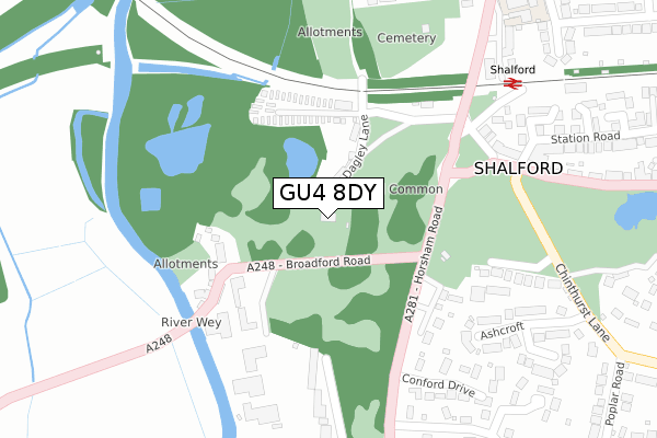
GU4 8DY is located in the Shalford electoral ward, within the local authority district of Guildford and the English Parliamentary constituency of Guildford. The Sub Integrated Care Board (ICB) Location is NHS Surrey Heartlands ICB - 92A and the police force is Surrey. This postcode has been in use since February 2017.


GetTheData
Source: OS Open Zoomstack (Ordnance Survey)
Licence: Open Government Licence (requires attribution)
Attribution: Contains OS data © Crown copyright and database right 2025
Source: Open Postcode Geo
Licence: Open Government Licence (requires attribution)
Attribution: Contains OS data © Crown copyright and database right 2025; Contains Royal Mail data © Royal Mail copyright and database right 2025; Source: Office for National Statistics licensed under the Open Government Licence v.3.0
| Easting | 499916 |
| Northing | 146899 |
| Latitude | 51.212561 |
| Longitude | -0.570903 |
GetTheData
Source: Open Postcode Geo
Licence: Open Government Licence
| Country | England |
| Postcode District | GU4 |
➜ See where GU4 is on a map ➜ Where is Shalford? | |
GetTheData
Source: Land Registry Price Paid Data
Licence: Open Government Licence
| Ward | Shalford |
| Constituency | Guildford |
GetTheData
Source: ONS Postcode Database
Licence: Open Government Licence
| Shalford Railway Station (Horsham Road) | Shalford | 218m |
| Shalford Railway Station (Horsham Road) | Shalford | 232m |
| Broadford Road | Broadford | 243m |
| Broadford Road | Broadford | 245m |
| Poplar Road (Horsham Road) | Shalford | 338m |
| Shalford (Surrey) Station | 0.3km |
| Guildford Station | 2.8km |
| Farncombe Station | 2.9km |
GetTheData
Source: NaPTAN
Licence: Open Government Licence
| Percentage of properties with Next Generation Access | 100.0% |
| Percentage of properties with Superfast Broadband | 100.0% |
| Percentage of properties with Ultrafast Broadband | 0.0% |
| Percentage of properties with Full Fibre Broadband | 0.0% |
Superfast Broadband is between 30Mbps and 300Mbps
Ultrafast Broadband is > 300Mbps
| Percentage of properties unable to receive 2Mbps | 0.0% |
| Percentage of properties unable to receive 5Mbps | 0.0% |
| Percentage of properties unable to receive 10Mbps | 0.0% |
| Percentage of properties unable to receive 30Mbps | 0.0% |
GetTheData
Source: Ofcom
Licence: Ofcom Terms of Use (requires attribution)
GetTheData
Source: ONS Postcode Database
Licence: Open Government Licence


➜ Get more ratings from the Food Standards Agency
GetTheData
Source: Food Standards Agency
Licence: FSA terms & conditions
| Last Collection | |||
|---|---|---|---|
| Location | Mon-Fri | Sat | Distance |
| Broadford Road, Shalford | 17:00 | 12:00 | 155m |
| Tillingbourne Road | 17:30 | 12:00 | 425m |
| Shalford Post Office | 17:00 | 12:00 | 478m |
GetTheData
Source: Dracos
Licence: Creative Commons Attribution-ShareAlike
The below table lists the International Territorial Level (ITL) codes (formerly Nomenclature of Territorial Units for Statistics (NUTS) codes) and Local Administrative Units (LAU) codes for GU4 8DY:
| ITL 1 Code | Name |
|---|---|
| TLJ | South East (England) |
| ITL 2 Code | Name |
| TLJ2 | Surrey, East and West Sussex |
| ITL 3 Code | Name |
| TLJ25 | West Surrey |
| LAU 1 Code | Name |
| E07000209 | Guildford |
GetTheData
Source: ONS Postcode Directory
Licence: Open Government Licence
The below table lists the Census Output Area (OA), Lower Layer Super Output Area (LSOA), and Middle Layer Super Output Area (MSOA) for GU4 8DY:
| Code | Name | |
|---|---|---|
| OA | E00155462 | |
| LSOA | E01030480 | Guildford 017E |
| MSOA | E02006360 | Guildford 017 |
GetTheData
Source: ONS Postcode Directory
Licence: Open Government Licence
| GU4 8BX | Juniper Terrace | 47m |
| GU4 8DA | Juniper Place | 77m |
| GU4 8DF | The Common | 137m |
| GU4 8DW | Broadford | 168m |
| GU4 8DR | Broadford | 171m |
| GU4 8DP | Broadford | 195m |
| GU4 8DS | Broadford | 224m |
| GU4 8DQ | Horsham Road | 231m |
| GU4 8DT | Broadford | 236m |
| GU4 8EP | Broadford Park Business Centre | 249m |
GetTheData
Source: Open Postcode Geo; Land Registry Price Paid Data
Licence: Open Government Licence