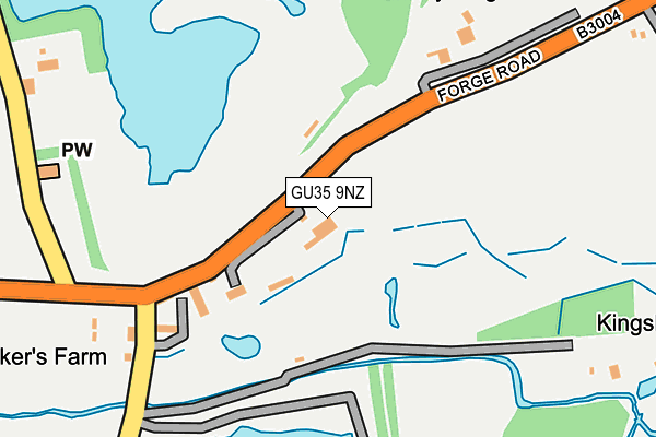
GU35 9NZ is located in the Binsted, Bentley & Selborne electoral ward, within the local authority district of East Hampshire and the English Parliamentary constituency of East Hampshire. The Sub Integrated Care Board (ICB) Location is NHS Hampshire and Isle of Wight ICB - D9Y0V and the police force is Hampshire. This postcode has been in use since October 2016.


GetTheData
Source: OS OpenMap – Local (Ordnance Survey)
Source: OS VectorMap District (Ordnance Survey)
Licence: Open Government Licence (requires attribution)
| Easting | 478107 |
| Northing | 137829 |
| Latitude | 51.134414 |
| Longitude | -0.885034 |
GetTheData
Source: Open Postcode Geo
Licence: Open Government Licence
| Country | England |
| Postcode District | GU35 |
➜ See where GU35 is on a map | |
GetTheData
Source: Land Registry Price Paid Data
Licence: Open Government Licence
Elevation or altitude of GU35 9NZ as distance above sea level:
| Metres | Feet | |
|---|---|---|
| Elevation | 70m | 230ft |
Elevation is measured from the approximate centre of the postcode, to the nearest point on an OS contour line from OS Terrain 50, which has contour spacing of ten vertical metres.
➜ How high above sea level am I? Find the elevation of your current position using your device's GPS.
GetTheData
Source: Open Postcode Elevation
Licence: Open Government Licence
| Ward | Binsted, Bentley & Selborne |
| Constituency | East Hampshire |
GetTheData
Source: ONS Postcode Database
Licence: Open Government Licence
| Bakers Corner (B3004 Green Street) | Kingsley | 216m |
| Bakers Corner (B3004 Green Street) | Kingsley | 228m |
| The Cricketers Inn (B3004 Forge Road) | Kingsley | 659m |
| The Cricketers Inn (B3004 Forge Road) | Kingsley | 661m |
| Rookery Farm (Roman Road) | Shortheath | 998m |
GetTheData
Source: NaPTAN
Licence: Open Government Licence
GetTheData
Source: ONS Postcode Database
Licence: Open Government Licence


➜ Get more ratings from the Food Standards Agency
GetTheData
Source: Food Standards Agency
Licence: FSA terms & conditions
| Last Collection | |||
|---|---|---|---|
| Location | Mon-Fri | Sat | Distance |
| Bakers Corner | 16:15 | 07:45 | 271m |
| Kingsley Post Office | 16:00 | 09:15 | 816m |
| Wheatley Lane | 16:00 | 09:00 | 1,320m |
GetTheData
Source: Dracos
Licence: Creative Commons Attribution-ShareAlike
The below table lists the International Territorial Level (ITL) codes (formerly Nomenclature of Territorial Units for Statistics (NUTS) codes) and Local Administrative Units (LAU) codes for GU35 9NZ:
| ITL 1 Code | Name |
|---|---|
| TLJ | South East (England) |
| ITL 2 Code | Name |
| TLJ3 | Hampshire and Isle of Wight |
| ITL 3 Code | Name |
| TLJ36 | Central Hampshire |
| LAU 1 Code | Name |
| E07000085 | East Hampshire |
GetTheData
Source: ONS Postcode Directory
Licence: Open Government Licence
The below table lists the Census Output Area (OA), Lower Layer Super Output Area (LSOA), and Middle Layer Super Output Area (MSOA) for GU35 9NZ:
| Code | Name | |
|---|---|---|
| OA | E00115051 | |
| LSOA | E01022630 | East Hampshire 008A |
| MSOA | E02004704 | East Hampshire 008 |
GetTheData
Source: ONS Postcode Directory
Licence: Open Government Licence
| GU35 9NJ | 185m | |
| GU35 9NW | 290m | |
| GU35 9NG | Main Road | 487m |
| GU35 9NH | Sandy Lane | 700m |
| GU35 9ND | Main Road | 701m |
| GU35 9NE | Kingsley Common | 751m |
| GU35 9NF | Kingsley Common | 769m |
| GU35 9HE | 773m | |
| GU35 9JS | 787m | |
| GU35 9NB | Woodfield | 890m |
GetTheData
Source: Open Postcode Geo; Land Registry Price Paid Data
Licence: Open Government Licence