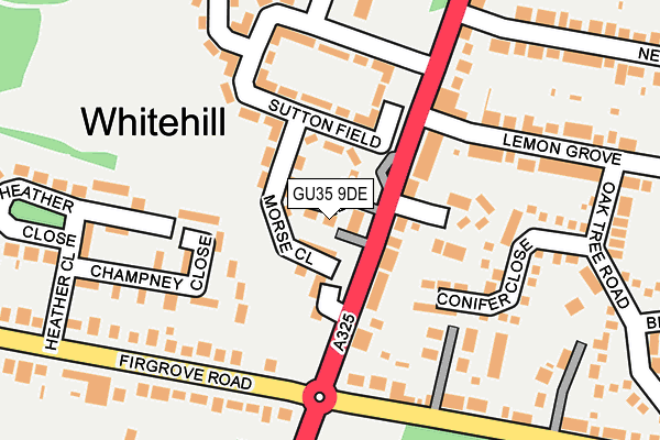
GU35 9DE is located in the Whitehill Hogmoor & Greatham electoral ward, within the local authority district of East Hampshire and the English Parliamentary constituency of East Hampshire. The Sub Integrated Care Board (ICB) Location is NHS Hampshire and Isle of Wight ICB - D9Y0V and the police force is Hampshire. This postcode has been in use since July 2017.


GetTheData
Source: OS OpenMap – Local (Ordnance Survey)
Source: OS VectorMap District (Ordnance Survey)
Licence: Open Government Licence (requires attribution)
| Easting | 479212 |
| Northing | 134167 |
| Latitude | 51.101339 |
| Longitude | -0.870047 |
GetTheData
Source: Open Postcode Geo
Licence: Open Government Licence
| Country | England |
| Postcode District | GU35 |
➜ See where GU35 is on a map ➜ Where is Whitehill? | |
GetTheData
Source: Land Registry Price Paid Data
Licence: Open Government Licence
| Ward | Whitehill Hogmoor & Greatham |
| Constituency | East Hampshire |
GetTheData
Source: ONS Postcode Database
Licence: Open Government Licence
| Bus Turning Circle (Petersfield Road) | Whitehill | 68m |
| Bus Turning Circle (Petersfield Road) | Whitehill | 88m |
| Mayflower Road (Liphook Road) | Whitehill | 206m |
| Mayflower Road (Liphook Road) | Whitehill | 208m |
| Heather Close (Firgrove Road) | Bordon | 274m |
| Liphook Station | 5.9km |
GetTheData
Source: NaPTAN
Licence: Open Government Licence
| Percentage of properties with Next Generation Access | 100.0% |
| Percentage of properties with Superfast Broadband | 100.0% |
| Percentage of properties with Ultrafast Broadband | 0.0% |
| Percentage of properties with Full Fibre Broadband | 0.0% |
Superfast Broadband is between 30Mbps and 300Mbps
Ultrafast Broadband is > 300Mbps
| Median download speed | 36.1Mbps |
| Average download speed | 34.6Mbps |
| Maximum download speed | 73.31Mbps |
| Median upload speed | 8.3Mbps |
| Average upload speed | 8.5Mbps |
| Maximum upload speed | 18.09Mbps |
| Percentage of properties unable to receive 2Mbps | 0.0% |
| Percentage of properties unable to receive 5Mbps | 0.0% |
| Percentage of properties unable to receive 10Mbps | 0.0% |
| Percentage of properties unable to receive 30Mbps | 0.0% |
GetTheData
Source: Ofcom
Licence: Ofcom Terms of Use (requires attribution)
GetTheData
Source: ONS Postcode Database
Licence: Open Government Licence


➜ Get more ratings from the Food Standards Agency
GetTheData
Source: Food Standards Agency
Licence: FSA terms & conditions
| Last Collection | |||
|---|---|---|---|
| Location | Mon-Fri | Sat | Distance |
| Whitehill Post Office | 17:15 | 09:00 | 89m |
| Tesco | 16:45 | 12:00 | 966m |
| Forest Centre Post Office | 17:15 | 12:15 | 1,202m |
GetTheData
Source: Dracos
Licence: Creative Commons Attribution-ShareAlike
The below table lists the International Territorial Level (ITL) codes (formerly Nomenclature of Territorial Units for Statistics (NUTS) codes) and Local Administrative Units (LAU) codes for GU35 9DE:
| ITL 1 Code | Name |
|---|---|
| TLJ | South East (England) |
| ITL 2 Code | Name |
| TLJ3 | Hampshire and Isle of Wight |
| ITL 3 Code | Name |
| TLJ36 | Central Hampshire |
| LAU 1 Code | Name |
| E07000085 | East Hampshire |
GetTheData
Source: ONS Postcode Directory
Licence: Open Government Licence
The below table lists the Census Output Area (OA), Lower Layer Super Output Area (LSOA), and Middle Layer Super Output Area (MSOA) for GU35 9DE:
| Code | Name | |
|---|---|---|
| OA | E00115085 | |
| LSOA | E01032663 | East Hampshire 008E |
| MSOA | E02004704 | East Hampshire 008 |
GetTheData
Source: ONS Postcode Directory
Licence: Open Government Licence
| GU35 9BJ | Morse Close | 37m |
| GU35 9BU | Petersfield Road | 65m |
| GU35 9BH | Peel Place | 69m |
| GU35 9BT | Petersfield Road | 102m |
| GU35 9BY | Petersfield Road | 108m |
| GU35 9BP | Sutton Field | 110m |
| GU35 9BL | Princes Close | 120m |
| GU35 9DB | Mayflower Road | 151m |
| GU35 9DX | Champney Close | 160m |
| GU35 9DH | Conifer Close | 161m |
GetTheData
Source: Open Postcode Geo; Land Registry Price Paid Data
Licence: Open Government Licence