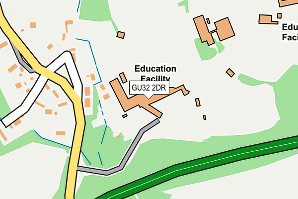
GU32 2DR is located in the Froxfield, Sheet & Steep electoral ward, within the local authority district of East Hampshire and the English Parliamentary constituency of East Hampshire. The Sub Integrated Care Board (ICB) Location is NHS Hampshire and Isle of Wight ICB - D9Y0V and the police force is Hampshire. This postcode has been in use since January 1980.


GetTheData
Source: OS OpenMap – Local (Ordnance Survey)
Source: OS VectorMap District (Ordnance Survey)
Licence: Open Government Licence (requires attribution)
| Easting | 474158 |
| Northing | 124815 |
| Latitude | 51.017939 |
| Longitude | -0.944146 |
GetTheData
Source: Open Postcode Geo
Licence: Open Government Licence
| Country | England |
| Postcode District | GU32 |
➜ See where GU32 is on a map ➜ Where is Steep? | |
GetTheData
Source: Land Registry Price Paid Data
Licence: Open Government Licence
Elevation or altitude of GU32 2DR as distance above sea level:
| Metres | Feet | |
|---|---|---|
| Elevation | 90m | 295ft |
Elevation is measured from the approximate centre of the postcode, to the nearest point on an OS contour line from OS Terrain 50, which has contour spacing of ten vertical metres.
➜ How high above sea level am I? Find the elevation of your current position using your device's GPS.
GetTheData
Source: Open Postcode Elevation
Licence: Open Government Licence
| Ward | Froxfield, Sheet & Steep |
| Constituency | East Hampshire |
GetTheData
Source: ONS Postcode Database
Licence: Open Government Licence
| Bedales School (School Grounds) | Steep | 440m |
| Bell Hill Ridge (Bell Hill) | Bell Hill | 496m |
| Bell Hill Ridge (Bell Hill) | Bell Hill | 523m |
| The Cricketers (Bell Hill) | Steep | 589m |
| The Cricketers (Bell Hill) | Steep | 596m |
| Petersfield Station | 1.3km |
| Liss Station | 4.6km |
GetTheData
Source: NaPTAN
Licence: Open Government Licence
GetTheData
Source: ONS Postcode Database
Licence: Open Government Licence


➜ Get more ratings from the Food Standards Agency
GetTheData
Source: Food Standards Agency
Licence: FSA terms & conditions
| Last Collection | |||
|---|---|---|---|
| Location | Mon-Fri | Sat | Distance |
| Dunhurst | 16:00 | 07:30 | 189m |
| Church Road | 16:00 | 08:15 | 554m |
| Steep Old Post Office | 16:00 | 10:15 | 566m |
GetTheData
Source: Dracos
Licence: Creative Commons Attribution-ShareAlike
The below table lists the International Territorial Level (ITL) codes (formerly Nomenclature of Territorial Units for Statistics (NUTS) codes) and Local Administrative Units (LAU) codes for GU32 2DR:
| ITL 1 Code | Name |
|---|---|
| TLJ | South East (England) |
| ITL 2 Code | Name |
| TLJ3 | Hampshire and Isle of Wight |
| ITL 3 Code | Name |
| TLJ36 | Central Hampshire |
| LAU 1 Code | Name |
| E07000085 | East Hampshire |
GetTheData
Source: ONS Postcode Directory
Licence: Open Government Licence
The below table lists the Census Output Area (OA), Lower Layer Super Output Area (LSOA), and Middle Layer Super Output Area (MSOA) for GU32 2DR:
| Code | Name | |
|---|---|---|
| OA | E00114881 | |
| LSOA | E01022597 | East Hampshire 011B |
| MSOA | E02004707 | East Hampshire 011 |
GetTheData
Source: ONS Postcode Directory
Licence: Open Government Licence
| GU32 2DP | 178m | |
| GU32 2EL | White House Gardens | 311m |
| GU32 2DX | Bell Hill | 354m |
| GU32 2HS | Tilmore Road | 400m |
| GU32 2DU | Coxes Meadow | 421m |
| GU32 2DZ | Bell Hill Ridge | 529m |
| GU32 2DY | Bell Hill | 550m |
| GU32 2DF | Church Road | 568m |
| GU32 2DQ | Church Road | 572m |
| GU32 2DN | Church Road | 585m |
GetTheData
Source: Open Postcode Geo; Land Registry Price Paid Data
Licence: Open Government Licence