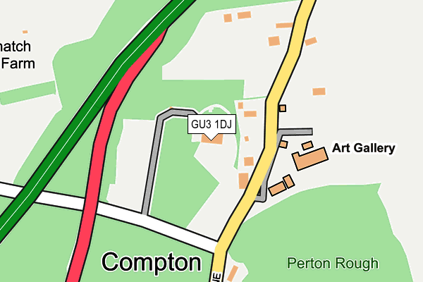
GU3 1DJ lies on Down Lane in Compton, Guildford. GU3 1DJ is located in the Shalford electoral ward, within the local authority district of Guildford and the English Parliamentary constituency of Guildford. The Sub Integrated Care Board (ICB) Location is NHS Surrey Heartlands ICB - 92A and the police force is Surrey. This postcode has been in use since January 1980.


GetTheData
Source: OS OpenMap – Local (Ordnance Survey)
Source: OS VectorMap District (Ordnance Survey)
Licence: Open Government Licence (requires attribution)
| Easting | 495707 |
| Northing | 147827 |
| Latitude | 51.221623 |
| Longitude | -0.630897 |
GetTheData
Source: Open Postcode Geo
Licence: Open Government Licence
| Street | Down Lane |
| Locality | Compton |
| Town/City | Guildford |
| Country | England |
| Postcode District | GU3 |
➜ See where GU3 is on a map ➜ Where is Compton? | |
GetTheData
Source: Land Registry Price Paid Data
Licence: Open Government Licence
Elevation or altitude of GU3 1DJ as distance above sea level:
| Metres | Feet | |
|---|---|---|
| Elevation | 80m | 262ft |
Elevation is measured from the approximate centre of the postcode, to the nearest point on an OS contour line from OS Terrain 50, which has contour spacing of ten vertical metres.
➜ How high above sea level am I? Find the elevation of your current position using your device's GPS.
GetTheData
Source: Open Postcode Elevation
Licence: Open Government Licence
| Ward | Shalford |
| Constituency | Guildford |
GetTheData
Source: ONS Postcode Database
Licence: Open Government Licence
| Watts Gallery (Down Lane) | Compton | 85m |
| Watts Gallery (Down Lane) | Compton | 96m |
| Down Lane (The Street) | Compton | 515m |
| Down Lane (The Street) | Compton | 529m |
| Flexford House (A3 Hogs Back) | Hog's Back | 760m |
| Farncombe Station | 3.3km |
| Wanborough Station | 3.6km |
| Guildford Station | 3.9km |
GetTheData
Source: NaPTAN
Licence: Open Government Licence
GetTheData
Source: ONS Postcode Database
Licence: Open Government Licence


➜ Get more ratings from the Food Standards Agency
GetTheData
Source: Food Standards Agency
Licence: FSA terms & conditions
| Last Collection | |||
|---|---|---|---|
| Location | Mon-Fri | Sat | Distance |
| Watts Gallery | 16:45 | 07:00 | 108m |
| The Street | 16:30 | 07:45 | 792m |
| Almsgate | 16:30 | 11:30 | 855m |
GetTheData
Source: Dracos
Licence: Creative Commons Attribution-ShareAlike
The below table lists the International Territorial Level (ITL) codes (formerly Nomenclature of Territorial Units for Statistics (NUTS) codes) and Local Administrative Units (LAU) codes for GU3 1DJ:
| ITL 1 Code | Name |
|---|---|
| TLJ | South East (England) |
| ITL 2 Code | Name |
| TLJ2 | Surrey, East and West Sussex |
| ITL 3 Code | Name |
| TLJ25 | West Surrey |
| LAU 1 Code | Name |
| E07000209 | Guildford |
GetTheData
Source: ONS Postcode Directory
Licence: Open Government Licence
The below table lists the Census Output Area (OA), Lower Layer Super Output Area (LSOA), and Middle Layer Super Output Area (MSOA) for GU3 1DJ:
| Code | Name | |
|---|---|---|
| OA | E00155456 | |
| LSOA | E01030478 | Guildford 017C |
| MSOA | E02006360 | Guildford 017 |
GetTheData
Source: ONS Postcode Directory
Licence: Open Government Licence
| GU3 1DQ | Down Lane | 166m |
| GU3 1DN | Down Lane | 425m |
| GU3 1DL | Hogs Back | 426m |
| GU3 1ED | The Street | 618m |
| GU3 1EF | Eastbury Lane | 710m |
| GU3 1EB | The Street | 729m |
| GU3 1DG | Hogs Back | 770m |
| GU3 1EE | Eastbury Lane | 771m |
| GU3 1JQ | Spiceall | 800m |
| GU3 1EG | The Street | 862m |
GetTheData
Source: Open Postcode Geo; Land Registry Price Paid Data
Licence: Open Government Licence