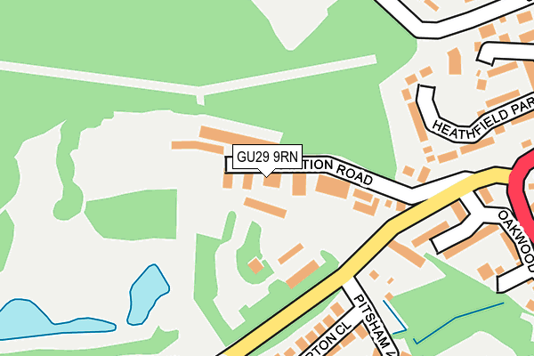
GU29 9RN is located in the Midhurst electoral ward, within the local authority district of Chichester and the English Parliamentary constituency of Chichester. The Sub Integrated Care Board (ICB) Location is NHS Sussex ICB - 70F and the police force is Sussex. This postcode has been in use since June 1997.


GetTheData
Source: OS OpenMap – Local (Ordnance Survey)
Source: OS VectorMap District (Ordnance Survey)
Licence: Open Government Licence (requires attribution)
| Easting | 487771 |
| Northing | 121130 |
| Latitude | 50.982890 |
| Longitude | -0.750989 |
GetTheData
Source: Open Postcode Geo
Licence: Open Government Licence
| Country | England |
| Postcode District | GU29 |
➜ See where GU29 is on a map ➜ Where is Midhurst? | |
GetTheData
Source: Land Registry Price Paid Data
Licence: Open Government Licence
Elevation or altitude of GU29 9RN as distance above sea level:
| Metres | Feet | |
|---|---|---|
| Elevation | 40m | 131ft |
Elevation is measured from the approximate centre of the postcode, to the nearest point on an OS contour line from OS Terrain 50, which has contour spacing of ten vertical metres.
➜ How high above sea level am I? Find the elevation of your current position using your device's GPS.
GetTheData
Source: Open Postcode Elevation
Licence: Open Government Licence
| Ward | Midhurst |
| Constituency | Chichester |
GetTheData
Source: ONS Postcode Database
Licence: Open Government Licence
| Bepton Road Recycling Site (Bepton Road) | Midhurst | 128m |
| Bepton Road Recycling Site (Bepton Road) | Midhurst | 144m |
| Pitsham Wood | Midhurst | 261m |
| Pitsham Wood | Midhurst | 266m |
| Oakwood Close | Midhurst | 286m |
GetTheData
Source: NaPTAN
Licence: Open Government Licence
GetTheData
Source: ONS Postcode Database
Licence: Open Government Licence


➜ Get more ratings from the Food Standards Agency
GetTheData
Source: Food Standards Agency
Licence: FSA terms & conditions
| Last Collection | |||
|---|---|---|---|
| Location | Mon-Fri | Sat | Distance |
| Half Moon Public House | 17:15 | 11:30 | 668m |
| Midhurst Delivery Office | 18:00 | 12:30 | 851m |
| Bepton Common | 17:15 | 09:15 | 988m |
GetTheData
Source: Dracos
Licence: Creative Commons Attribution-ShareAlike
The below table lists the International Territorial Level (ITL) codes (formerly Nomenclature of Territorial Units for Statistics (NUTS) codes) and Local Administrative Units (LAU) codes for GU29 9RN:
| ITL 1 Code | Name |
|---|---|
| TLJ | South East (England) |
| ITL 2 Code | Name |
| TLJ2 | Surrey, East and West Sussex |
| ITL 3 Code | Name |
| TLJ27 | West Sussex (South West) |
| LAU 1 Code | Name |
| E07000225 | Chichester |
GetTheData
Source: ONS Postcode Directory
Licence: Open Government Licence
The below table lists the Census Output Area (OA), Lower Layer Super Output Area (LSOA), and Middle Layer Super Output Area (MSOA) for GU29 9RN:
| Code | Name | |
|---|---|---|
| OA | E00160705 | |
| LSOA | E01031511 | Chichester 004C |
| MSOA | E02006564 | Chichester 004 |
GetTheData
Source: ONS Postcode Directory
Licence: Open Government Licence
| GU29 9RE | Wedglen Industrial Estate | 37m |
| GU29 9QT | Bepton Road | 148m |
| GU29 9QY | Railway Terrace | 170m |
| GU29 9QR | Bepton Close | 190m |
| GU29 9HN | Heathfield Park | 221m |
| GU29 9QS | Oakwood Close | 225m |
| GU29 9HL | Heathfield Park | 301m |
| GU29 9LD | Carron Lane | 312m |
| GU29 9PS | Heathfield Close | 312m |
| GU29 9JB | Heathfield Gate | 316m |
GetTheData
Source: Open Postcode Geo; Land Registry Price Paid Data
Licence: Open Government Licence